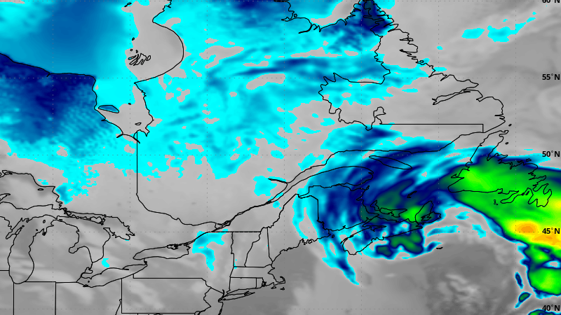
Forecasts continue to indicate the likelihood of a potent winter storm during the middle part of the upcoming work week. Significant snow and high wind speeds could affect much of the island and coastal Labrador between Wednesday and Friday, or Saturday. There is also the chance eastern areas see a change to ice pellets and/or rain for a time as well.

A strong area of low pressure will develop off the coast of New England on Tuesday and will then track toward the northeast, passing southeast of Atlantic Canada between Tuesday night and Wednesday. The low will then stall near Newfoundland and Labrador through Friday. This track will spread snow across much of the region in that time frame. On the Island, the snow will arrive late Tuesday night or early Wednesday morning. The snow will continue to fall into Thursday before becoming a little less stratiform on Friday and Saturday. Eastern areas may see the snow change to ice pellets or rain for a time later Wednesday before going back to snow Thursday. However, there is some uncertainty in that as it will depend on just how close the low tracks to the Avalon Peninsula.

While it is still too early to pinpoint snowfall amounts, the chance of heavy snowfall and high wind speeds across much of the region is increasing. A storm of this magnitude will has the potential to hamper road, air, and sea travel across the Province for several days.
More updates to come.
-
Letter-Writing Event to Mark Rainbow Week of Action in St. John’s
From May 11th to 17th, 2SLGBTQIA+ advocates and allies across Canada are speaking up for…
-

Man arrested after causing damage to home in St. John’s
Thursday evening the RNC responded to the east end of St. John’s where an individual was said to be…
-

Moose killed, no other injuries, following collision on Outer Ring Road
A moose-vehicle collision on the Outer Ring Road on Thursday evening killed the animal and…