


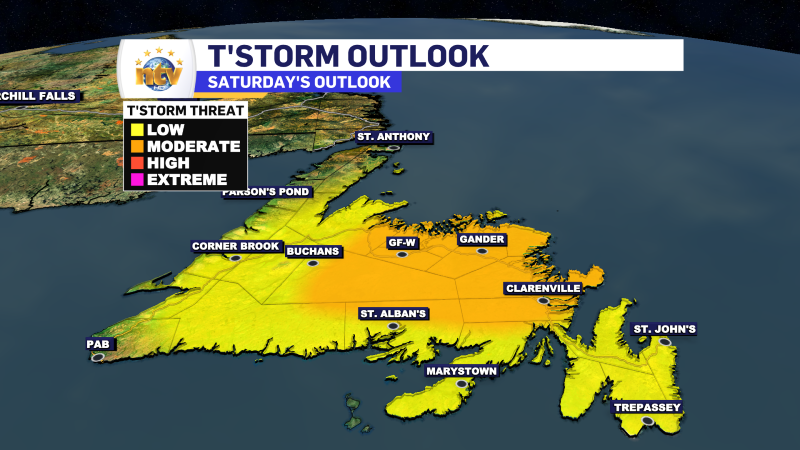
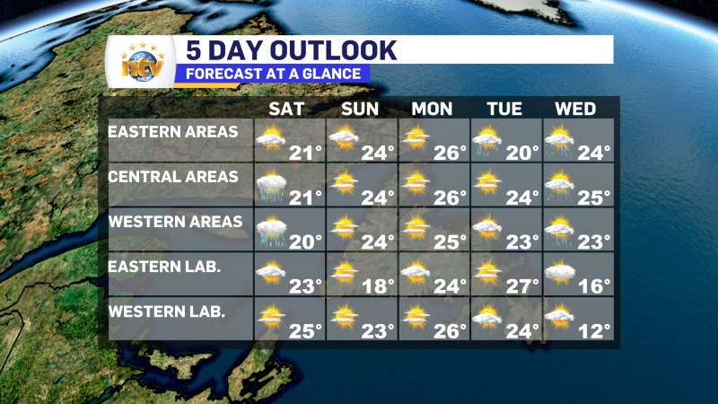
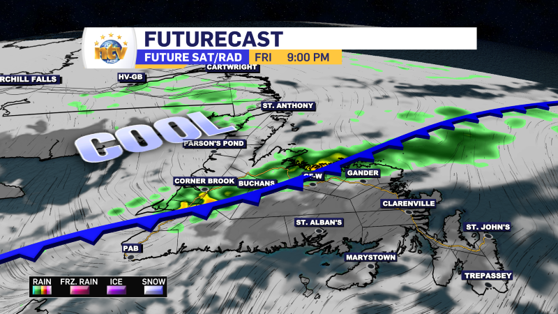
An upper-level pressure center will pass over the Island between Friday night and Saturday. This will bring widespread showers and possible thunderstorms, more than widespread stratiform rain. The best chance of showers and thunderstorms Friday evening and night will be over the western half of the Island. Saturday, the best chance of showers and thunderstorms will be over central and northeastern areas of the Island, particularly in the afternoon.
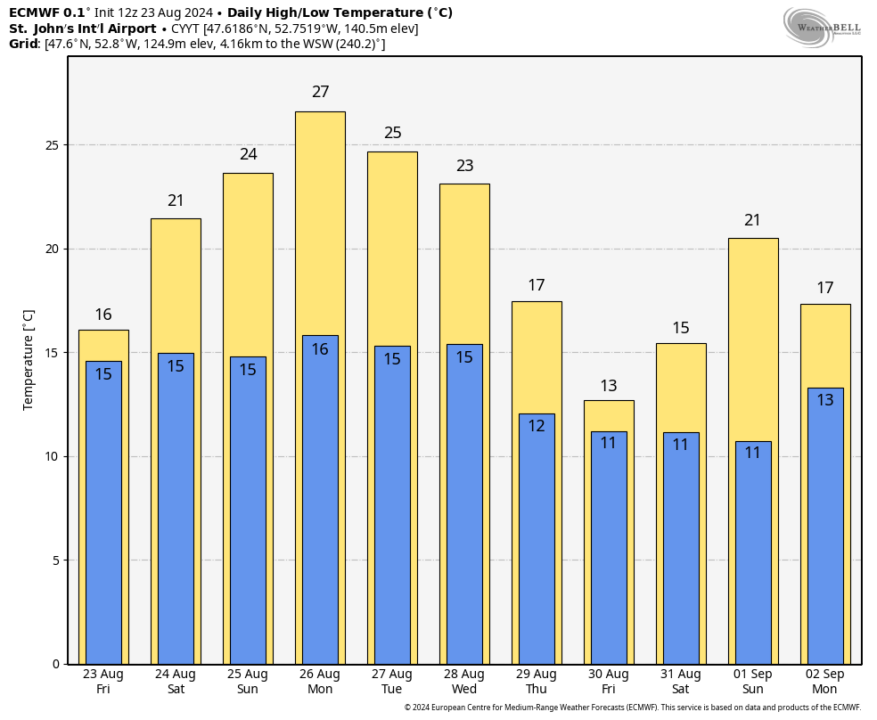
The weather across much of the province will be quiet during the second half of the weekend and into Tuesday of next week. The exception will be on the Avlaon and over eastern areas, where an area of low pressure may drive some showers or some rain on Tuesday. The next weather threat will be a cold front that may bring some showers to the Island Wednesday. That some front will bring some showers to Labrador Tuesday.

The cold front will bring a cool down to Labrador for the middle part of next week and the Island between Wednesday and Thursday. Highs will drip into the teens for those couple of days before a return to 20s for the holiday weekend… or so it looks now.

The Forecast
The Newfoundland Outlook
Tonight
Areas of rain, showers and thunderstorms will end during the overnight over eastern areas, and the Great Northern Peninsula. Showers will become a bit more widespread along and near the West Coast late in the overnight. Low temperatures of 12 to 16.
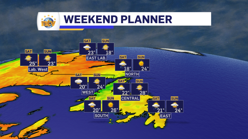
Saturday
A mix of sun and cloud, with high temperatures near 20. There will be some scattered showers on the West Coast. During the afternoon, scattered showers and thunderstorms develop over central and interior Newfoundland and will move to the east-northeast. The risk of showers extends onto the Avalon, but should remain north of the South Coast and Burin Peninsula. Some of the storms will be strong and will produce locally heavy rain, gusty winds and frequent thunder and lightning.
Sunday
A mix of sun and cloud across the Island. High temperatures reach the middle 20s.
Monday
Mostly sunny with high temperatures in the middle 20s.
Tuesday
There is a chance of showers for the Avalon and Burin Peninsulas. Sunny elsewhere. High temperatures in the lower to middle 20s.
Wednesday
Mostly cloudy with a chance of showers. High temperatures in the lower 20s.
The Labrador Outlook
Tonight
Mostly clear with a low near 10.
Saturday
Sunny with a high in the lower to middle 20s
Sunday
Sunny with a high in the upper teens to lower 20s
Monday
Sunny with high in the middle 20s.
Tuesday
Risk of showers in the west, otherwise sun and cloud. High temperatures in the middle to upper 20s.
Wednesday
Mostly cloudy and cooler with a high in the middle teens.
-
Showers return Friday ahead of cold front
FROST ADVISORY IN EFFECT FOR TONIGHT ….. CLICK HERE FOR DETAILS HERE TONIGHT Clear on…
-
Thursday’s Forecast: Sunny and near 20 for most!
THURSDAY Sunny on the Island HIghs of 16° to 18° Dry to start the day…
-
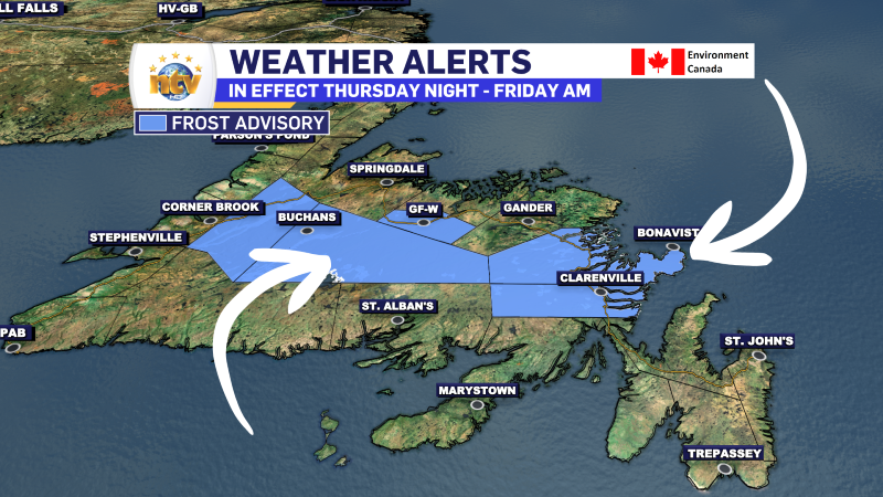
Frost Advisory issued for Thursday night
Clear skies and light winds will coincide with cool temperatures Thursday night, bringing frost to…
