Search by City
CURRENT CONDITIONS - St. John's
 13°C
13°C
Feels like 13°C
Visibility
24 km
Wind
11km NNW
Humidity
82%
UV
Low
Pressure
999.16 mb
High
°C
Low
°C
POP
%
Sunrise
12:00 AM
Sunset
12:00 AM
HOURLY WEATHER - St. John's
7:30 AM

15°C
 2%
2%8:30 AM
17°C
1%9:30 AM
19°C
3%10:30 AM
20°C
1%11:30 AM
21°C
0%12:30 PM
22°C
0%1:30 PM
23°C
0%2:30 PM
24°C
0%3:30 PM
24°C
0%4:30 PM
24°C
0%5:30 PM
23°C
0%6:30 PM
22°C
0%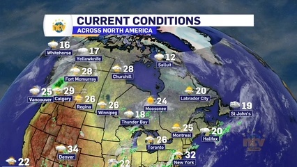

NEXT 7 DAYS - St. John's
Tomorrow
July 14
High
27°C
Low
15°C
4%
57%
Partly cloudy. High 27°C. Winds W at 15 to 25 km/h.
Tuesday
July 15

High
24°C
Low
16°C
7% 70%
Cloudy. High 24°C. Winds WSW at 15 to 30 km/h.
Wednesday
July 16
High
23°C
Low
14°C
8% 74%
Partly cloudy. High 23°C. Winds NW at 15 to 25 km/h.
Thursday
July 17
High
25°C
Low
14°C
16% 70%
Partly cloudy. High 25°C. Winds WSW at 10 to 15 km/h.
Friday
July 18

High
24°C
Low
16°C
22% 78%
Mostly cloudy. High 24°C. Winds SW at 15 to 30 km/h.
Saturday
July 19

High
21°C
Low
14°C
59% 85%
Showers. High 21°C. Winds W at 15 to 30 km/h. Chance of rain 60%.
Sunday
July 20

High
20°C
Low
13°C
33% 73%
Morning showers. High 20°C. Winds WNW at 10 to 15 km/h. Chance of rain 30%.