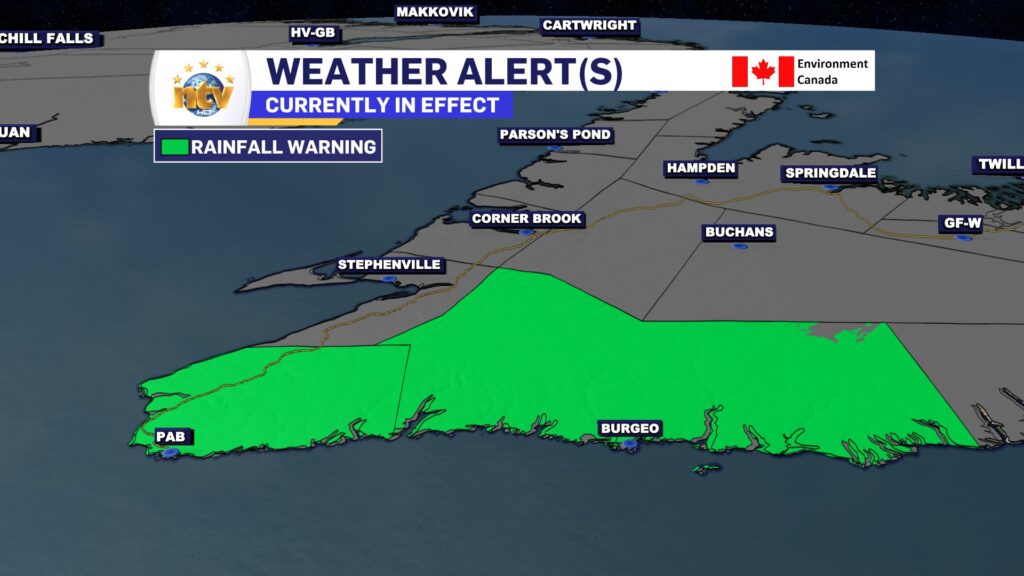
The ECCC N.L. Weather Office in Gander has issued a Rainfall Warning. It is in effect from Saturday (July 22, 2023) afternoon thru Sunday evening for the following areas:
- Channel – Port aux Basques & vicinity
- Burgeo – Ramea
Current details:
Rain, at times heavy, is expected.
Total rainfall: 50 to 80 mm, locally higher amounts possible.
Locations: southwestern Newfoundland.
Time span: this afternoon through Sunday night.
Similar storms in the past have caused hazardous driving conditions, elevated river levels, and localized flooding, especially in poor drainage areas,
Heavy downpours can cause flash floods and water pooling on roads. Localized flooding in low-lying areas is possible.
Rainfall warnings are issued when significant rainfall is expected.
This same system has produced extremely heavy rainfall in parts of Nova Scotia. Some areas around Halifax have seen over 250 mm of rain since Friday evening, and more is expected before it ends later today. While computer guidance did a good job nailing the location of the heavy rainfall in that area, the amounts predicted were vastly underdone.
Systems like this, in the current atmospheric setup we are in, can often over-produce forecasted values.
I’m of the opinion that the forecast amounts for parts of southern and southwest Newfoundland may also be too low, and that significantly higher amounts are possible… if not likely.
As stated above, similar storms in the past have caused high river levels and localized flooding.
Stay safe and never drive into flood waters.

-
High-profile minister Siobhan Coady not seeking re-election
Another high profile Liberal minister has announced she will not be seeking re-election. Following 10…
-

RCMP arrests man for assault with a weapon
Forty-five-year-old Darryl Dyson was arrested by Happy Valley-Goose Bay RCMP on July 4 in relation…
-
Plans in place during scheduled runway repairs at St. Anthony Airport
Newfoundland and Labrador Health Services advises the public that plans are in place to mitigate…