


7 months ago
Snow is in Friday’s forecast for the Island
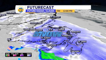
Friday afternoon update #1 | 1:21 PM NDT Snow continues to fly over much of the Island. Totals from Gander to St. John’s are in the 7 to 10 cm range. Both Rodney Barney and Kelly Butt has measured similar amounts thus far. While the snow is piling up on the grass and untreated surfaces, […]
Read more
7 months ago
NTV Weather Update | April 2, 2025
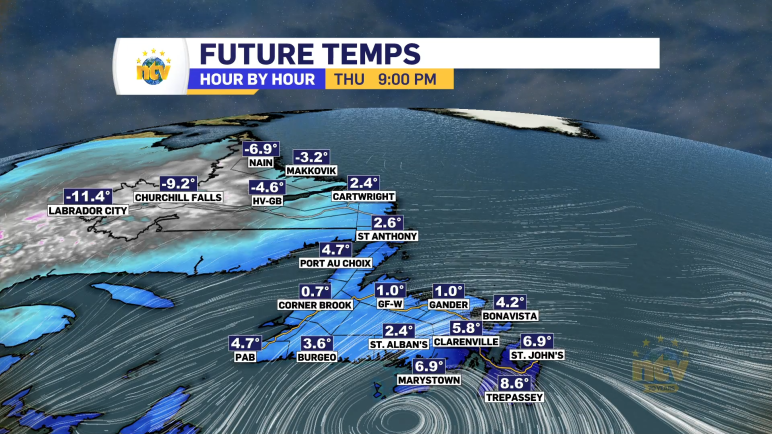
Today’s Synopsis The weather across the Island today will be much cooler than yesterday. High temperatures in some locations will be more than 15º colder! Rodney Barney, a Meteorologist with ECCC NL Weather Office in Gander, compiled yesterday’s maximums. In addition, there will be intense flurries and occasional snow squalls along and near the West […]
Read more
8 months ago
NTV Weather Update | April 1, 2025
Good morning! It’s April 1st, 2025, and this forecast is no April Fools joke! Today’s Synopsis An area of low pressure will move through the Lower North Shore of Quebec and the Straits of Labrador today and tonight. The track of this low will send a surge of warm air over much of the Island. […]
Read more
8 months ago
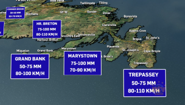
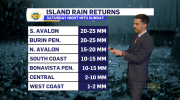
Spring storm delivers mixed bag of weather to NL through Tuesday
Snow, ice pellets, freezing rain and rain will be found across the Province over the next 24 to 48 hours. On top of that, we can expect temperatures to soar over the Island Tuesday afternoon into the lower teens! I broke the entire forecast down on Monday’s NTV Evening News Hour (above).
Read more