


The latest forecasts continue to indicate that a major, long-duration, winter storm will bring heavy snowfall and high wind speeds to a large area of the Island beginning late tonight or early Wednesday and continuing into Friday. Current forecasts also point toward a slightly colder scenario where most, if not all, of the mixed precipitation stays offshore. If this ends up being the case, the heaviest snow is going to fall over the northern Avalon Peninsula, including St. John’s, and parts of the northeast coast and Bonavista Peninsula.
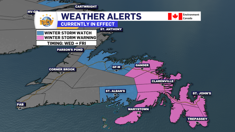
Environment and Climate Change Canada has issued multiple winter weather alerts in effect for various areas of the province and even portions of coastal Labrador ahead of this incoming winter storm. You can read a summary of the alerts below.
Remember that the forecast I release later today may be slightly different than EC’s.
A Winter Storm Warning is in effect for the following areas from Wednesday morning until Friday morning:
- The Avalon Peninsula North
- St. John’s & vicinity
- Bonavista North
- Bonavista Peninsula
- Clarenville & vicinity
- Gander & vicinity
- Terra Nova
Current details: Heavy snowfall with blowing snow is expected.
Locations: the northern Avalon Peninsula, eastern and northeastern Newfoundland.
Total snowfall: 30 to 50 cm, locally higher amounts possible.
Maximum wind gusts: northeasterly 80 km/h.
Time span: Wednesday morning until early Friday morning, with the heaviest snow expected Wednesday and Wednesday night.
Similar storms in the past have caused:
– hazardous driving conditions
– school closures and cancellations of scheduled activities
– disruptions to public services
Remarks: Conditions will deteriorate quickly Wednesday morning as accumulating snow occurs in conjunction with strengthening winds.
Snowfall rates of 2 to 3 centimetres per hour are possible before gradually diminishing in intensity on Thursday. However, a stiff northwesterly flow and continued snowfall will continue to cause poor conditions.
As with all nor’easters, a small change in the forecast track results in large changes in the snowfall forecast. This alert represents the current most probable scenario based on the latest forecast guidance and analysis. This alert and corresponding local forecasts will be updated regularly with the latest guidance and analysis by Environment Canada meteorologists.
Poor weather conditions may contribute to transportation delays. Consider postponing non-essential travel until conditions improve.
Winter storm warnings are issued when multiple types of severe winter weather are expected to occur together.
A Winter Storm Warning is in effect from Wednesday morning until Thursday morning for the following areas:
- Avalon Peninsula Southeast
- Avalon Peninsula Southwest
- Burin Peninsula
Current details: Heavy snowfall with blowing snow is expected.
Locations: the Burin Peninsula and the southern Avalon Peninsula.
Total snowfall: 20 to 35 cm.
Maximum wind gusts: northeasterly 80 km/h, except 100 near Cape Race.
Time span: early Wednesday morning until Thursday evening.
Similar storms in the past have caused:
– hazardous driving conditions
– school closures and cancellations of scheduled activities
– disruptions to public services
Remarks: Conditions will deteriorate quickly Wednesday morning as accumulating snow occurs in conjunction with strengthening winds. Over the southeastern Avalon, snow will likely become mixed with ice pellets in the afternoon, which will help improve visibility in some areas.
As with all nor’easters, a small change in the forecast track results in large changes in the snowfall forecast. This alert represents the current most probable scenario based on the latest forecast guidance and analysis. This alert and corresponding local forecasts will be updated regularly with the latest guidance and analysis by Environment Canada meteorologists.
Poor weather conditions may contribute to transportation delays.
Consider postponing non-essential travel until conditions improve.
Winter storm warnings are issued when multiple types of severe winter weather are expected to occur together.
A Winter Storm Watch is in effect for the following areas from Wednesday morning until Friday morning:
- Grand Falls-Windsor & vicinity
- Bay of Exploits
- Green Bay-White Bay
- Connaigre Peninsula
Total snowfall: 15 to 30 cm spanning several days.
Maximum wind gusts: northeasterly 60 km/h, except 80 along parts of the coast
Time span: Wednesday morning until Friday morning.
Remarks: Current model guidance suggests that the incoming low pressure system may track farther east of the island than previously anticipated, and therefore snowfall accumulations may not reach warning criteria. However, poor travel conditions in snow and blowing snow are still likely for some areas.
Travel is expected to be hazardous due to reduced visibility in some locations. Poor weather conditions may contribute to transportation delays.
A Storm Surge Warning is in effect for Wednesday night’s high tide for the following areas:
- Avalon Peninsula North
- St. John’s & vicinity
- Bonavista North
- Bonavista Peninsula
- Clarenville & vicinity
- Terra Nova
Current details: Impacts from storm surge are expected, including coastal flooding, beach erosion, minor infrastructure damage, spread of coastal debris, and localized coastal road washouts.
Locations: Cape Spear to Deadman’s Bay, especially northeast-facing shorelines.
Maximum Water Levels: exceeding high astronomical tide, with water inundating vulnerable sections of coastline.
Maximum wave heights: 8 to 10 metres, breaking upon approach to shore.
Time span: Wednesday night. Worst near high tide.
High tide: 11 P.M. Wednesday to 1 A.M Thursday.
Storm surge warnings are issued when water levels pose a threat to coastal regions.
A Winter Storm Watch is in effect for for the following area from tonight through the weekend:
- Postville – Makkovik
Current details: A prolonged winter storm is possible.
Total snowfall: possibly exceeding 60 cm tonight through the weekend.
Maximum wind gusts: northerly 60 km/h.
Time span: tonight through the weekend.
Remarks: After periods of light snow today, snowfall rates will increase tonight in conjunction with strengthening northerly winds to cause poor visibility in blowing snow. Snow at times heavy and strong winds will likely persist through the weekend.
Rapidly accumulating snow could make travel difficult over some locations.
Winter storm watches are issued when multiple types of severe winter weather are expected to occur together.
I will have your latest forecast posted on the website this evening. Check back frequently for updates. I’ll also have your forecasts on NTV this evening, starting at 5:30 PM. Also, don’t forget to visit the NTV Weather Centre if you haven’t already!
-

Threat of wildfires on west coast higher this year, say forestry officials
As residents of the province prepare to head out into the woods for the Victoria…
-

Labrador West MHA wants water bomber back
With wildfires threatening Fort McMurray, Alta., again, Labrador West MHA Jordan Brown wants a water…
-

Province warns residents to be ready for forest fire season as wildfires threaten Fort McMurray
Evacuation orders and alerts remain in effect for Fort McMurray, Alta., as wildfires continue to…
