


An area of low pressure will swing over, or near, eastern Newfoundland Friday night into early Saturday morning. This will drive some snow, ice, and rain across southeastern and eastern Newfoundland in that time frame. This will be a relatively minor event, but snow in some areas will be enough for shoveling or snowblowing to be required on Saturday morning. Due to the impending weather, the ECCC NL Weather Office in Gander has issued a Special Weather Statement for the Avalon and Burin Peninsulas.
TIMING OUT THE PRECIPITATION
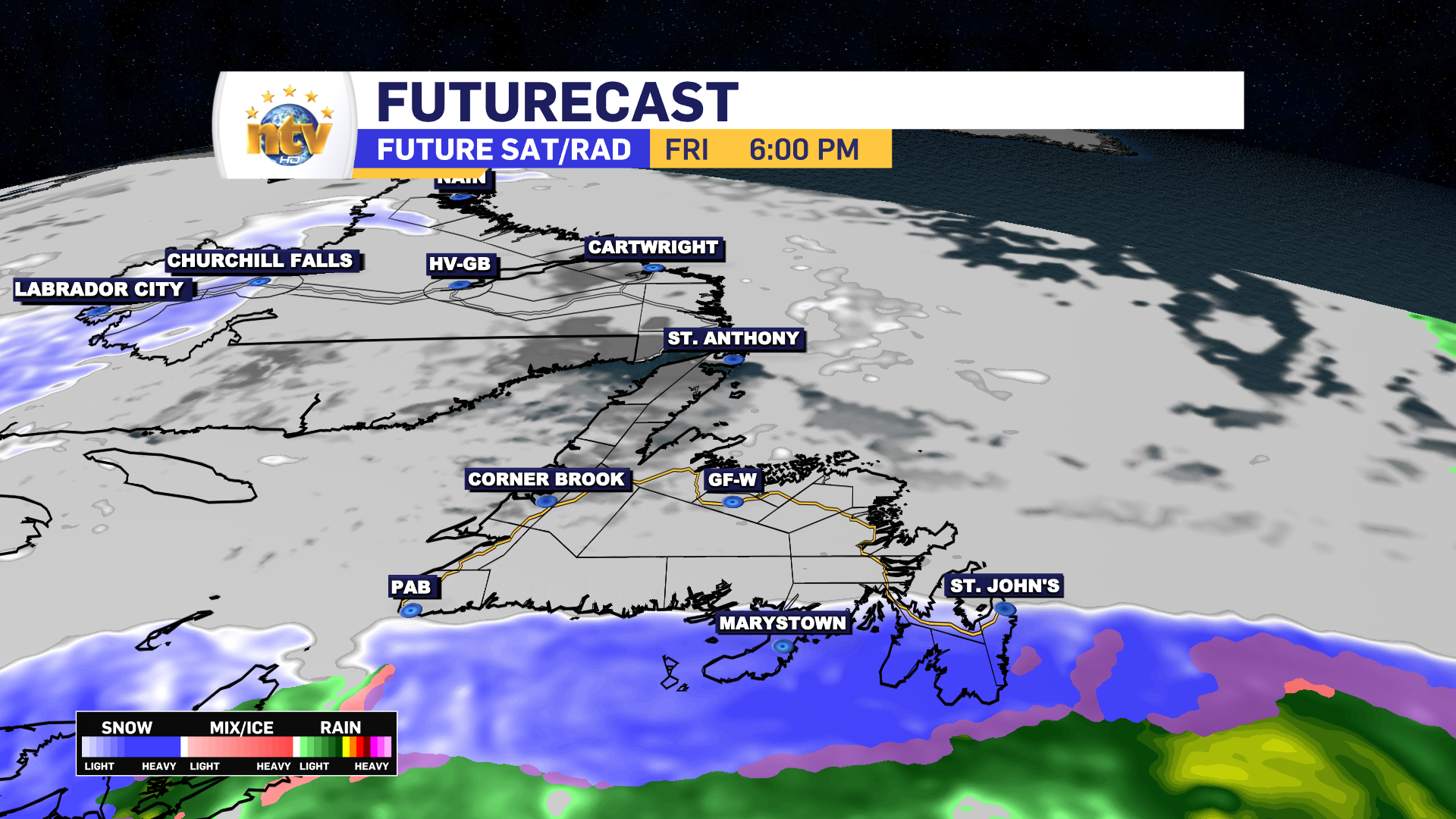
The snow will hold off until Friday afternoon or evening. So any travel between now and then will not be an issue across the Island, and the Province. Snow will arrive in on the Burin and Avalon Peninsulas between 3 PM and 6 PM Friday. It will arrive first in the south and last in the north (Metro).
Snow will become moderate to heavy over the Burin and Avalon Peninsula after 6 PM. After 9 PM Friday, ice pellets and/or freezing rain will start to arrive on the southern Avalon, which will migrate north overnight. Any mixing will arrive over northern areas of the Avlaon after midnight and before 6 AM. How far north the rain/snow/ice lines make it is still debatable. Areas west of the Avalon should stay primarily snow. The rain and snow will end from southwest to northeast between 8 AM and 12 PM on Saturday.

SNOW AND ICE AMOUNTS
Snow amounts over the Burin and Avalon Peninsulas will be in the 5 to 10 cm range between Friday night and Saturday morning. Locally higher amounts are possible, but not by more than a few centimeters. Areas that see ice pellets and/or freezing rain will get a glaze on things, especially trees and elevated surfaces, but it shouldn’t be enough to bring down trees or power lines. Areas that see rain Friday night will see a few millimeters. That may be enough to make the snow difficult to move Saturday morning.

Rest of the Forecast
Generally quiet weather will be found over the Province tonight, with lows of -5 to -10 on the Island and -6 to -18 in Labrador. Wind speeds will be light to moderate. Some snow will fly along the North Coast of Labrador.

Friday will see the snow arriving in southeastern Newfoundland late in the day, while the rest of the Island sees a sunny day. Highs of -1 east to -5 west and north. Labrador will see some flurries on the coast by afternoon, while inland and western areas will see some flurries and/or light snow. Mainly west of Goose Bay. Highs of -1 north to -5 south and -10 west.
Saturday sees some light snow ending over eastern Newfoundland in the morning, while Central and western areas wil see partly to mostly cloudy skies. There will be some scattered flurries around, especially on the West Coast. Highs of 0 to -2. Labrador will see scattered flurries, with highs of -2 in the east and -7 in the west.
Sunday looks a bit messier on the Island, with the chance of rain and snow in the east and snow central and west throughout the day. At this point, it’s a bit too early to get into amounts. Highs will be near freezing. Meanwhile, coastal Labrador will see some snow on Sunday, while sunshine will be present in the west. Highs of -2 east to near -10 west

Monday and Tuesday look fairly quiet across the region, with highs near or below freezing on the ISland under sun and cloud and highs near -10 across much of the Big Land under sunny skies. There will be some flurries over western Labrador and western Newfoundland.
-

Threat of wildfires on west coast higher this year, say forestry officials
As residents of the province prepare to head out into the woods for the Victoria…
-

Labrador West MHA wants water bomber back
With wildfires threatening Fort McMurray, Alta., again, Labrador West MHA Jordan Brown wants a water…
-

Province warns residents to be ready for forest fire season as wildfires threaten Fort McMurray
Evacuation orders and alerts remain in effect for Fort McMurray, Alta., as wildfires continue to…
