


Snow spreads the Island today and will continue through late Thursday or early Friday over much of the Island and through much of the weekend in coastal Labrador. This is because of a slow-moving Nor’Easter. The storm is currently located off the coast of Nova Scotia. It will pass east of the Avalon today and then stall in the Labrador Sea into Friday before finally departing… albeit slowly.
Ahead of the storm, the Environment and Climate Change Canada Weather Office in Gander has issued Winter Storm Warnings and Watches for much of the Island in the Postville – Makkovik area of Labrador. Remember, Winter Storm Warnings, or Watches are issued when multiple types of severe winter weather are expected to occur together. In this case it will be snow and wind gusts as high as 80 km/h.


On top of that, the slow-moving nature of this low will drive large waves and high surf along the northeast shorelines of the Island from near Cape Freels to Cape Race. A Storm Surge Warning is in effect for Wednesday night’s high tide. Water levels in some areas may exceed astronomical high tides. Those interestes along the coast should keep a close eye on the water as coastal flooding is possible.

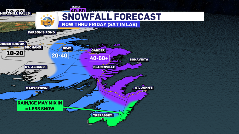
The bulk of the snow is going to fall on Wednesday on the island, but the accumulating snow will continue into early Friday. In Labrador, the snow will continue into the weekend. Snowfall amounts on the Island will peak over 60 cm in the east and northeast, with lesser amounts to the west. Labrador will see as much as 60 cm for some coastal areas as well by Sunday.
Snowfall rates will be as high as 4 cm an hour Wednesday afternoon over eastern Newfoundland, making travel quite difficult, if not impossible. Rates will be lower before and after but the snow and wind will make travel hard over large areas. The saving grace may be temperatures near 0, which prevent the snow from blowing around as well as if it were colder.

My forecast confidence is high; however, late Wednesday morning into the afternoon, some areas of the southern shore may see the snow mix with ice pellets or rain. If that happens, amounts in that area will be less than areas just west and north. I don’t think this mix line makes it as far north as the Metro, but I’ll be watching the radar and listening to the windows closely tomorrow afternoon for ice pellets.
The snow in Labrador will be more consistent, and it will linger into Saturday or Sunday. The highest amounts will be localized to the coast and Mealy Mountains, but significant snow is likely from Mary’s Haroubr to the Torngats and as far west as Happy Valley-Goose Bay

I’ll have updates throughout the day tomorrow, so be sure to check back frequently. Have a great night and stay safe.
-

Threat of wildfires on west coast higher this year, say forestry officials
As residents of the province prepare to head out into the woods for the Victoria…
-

Labrador West MHA wants water bomber back
With wildfires threatening Fort McMurray, Alta., again, Labrador West MHA Jordan Brown wants a water…
-

Province warns residents to be ready for forest fire season as wildfires threaten Fort McMurray
Evacuation orders and alerts remain in effect for Fort McMurray, Alta., as wildfires continue to…
