


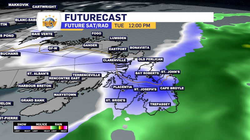
The area of low pressure that has driven the rain, snow, and fog across the region for the last few days will have another 24 hours with us before it finally departs late Tuesday night. Unfortunately, these 24 hours will include one more burst of wintry weather. This time, it looks like that will be over the eastern areas of the Island tomorrow, including the Avalon, specifically in the afternoon and evening. Areas to the west will see a bit more snow overnight, ending from west to east throughout the day on Tuesday.
TONIGHT ON THE ISLAND
- Rain and showers will continue for eastern and northeastern Newfoundland this evening. Areas west of the Avalon will see the rain change back to snow overnight. Lows of 0 to 1.
- Central, the West Coast, and GNP will see periods of snow and/or freezing drizzle overnight. Lows near 0.
- Cloudy skies will be found south, with lows also near 0.
- Wind speeds from the north at 30 to 60 km/h
TONIGHT IN LABRADOR
- Partly cloudy to mostly clear with lows of -13 to -15 in th east and as low as -30 in the west.
- Wind speeds will delight in the west and as high as 40 km/h from the north on the coast.
TUESDAY ON THE ISLAND
- Eastern Newfoundland / The Avalon
- Rain in the morning changes to snow by noon. The snow will be heavy at times in the afternoon before ending in the evening. Temperatures fall to near 0 and hold there.
- Snowfall amounts will be in the 5 to 15 cm range, with locally higher amounts possible.
- Wind speeds gust to 80 km/h from the north

- Central/Western/Southern/GNP
- Snow tapers to flurries central, west and north. Highs will be near 0 or a tad below.
- Skies try and clear out late on the South Coast.
- Wind speeds from the north at 20 to 40 km/h

TUESDAY IN LABRADOR
- Sun and cloud with highs of -7 to -14.
- Wind speeds of 25 km/h on the coast and light in the west
WEDNESDAY’S OUTLOOK
- Periods of freezing drizzle or flurries for north-facing shorelines of eastern and northeastern Newfoundland in onshore northerlies.
- Cloudy skies turn partly cloudy along the West Coast, GNP, South Coast and even southern areas of eastern Newfoundland.
- Highs of 0 to -2
- Labrador will see mostly sunny skies in the east and flurries west.
- Highs near -8
THURSDAY’S OUTLOOK
- Freezing drizzle may continue over the north-facing shores of eastern Newfoundland, while the sun will shine over a wider geographic area.
- Highs of 0 to -3
- Sun and cloud in Labraodr with of -5 to -10.
FRIDAY’S OUTLOOK
- Sun and cloud on the Island, with highs near 0
- A few flurries in Labrador, with highs of -2 to -4
SATURDAY’S OUTLOOK
- Partly cloudy skies on the Island with highs near 0.
- Flurries in Labrador, with highs of -2 to -5

-

Threat of wildfires on west coast higher this year, say forestry officials
As residents of the province prepare to head out into the woods for the Victoria…
-

Labrador West MHA wants water bomber back
With wildfires threatening Fort McMurray, Alta., again, Labrador West MHA Jordan Brown wants a water…
-

Province warns residents to be ready for forest fire season as wildfires threaten Fort McMurray
Evacuation orders and alerts remain in effect for Fort McMurray, Alta., as wildfires continue to…
