


A slow-moving, nearly stationary area of low pressure to the south and southwest of Newfoundland will bring a round of heavy rain, snow, and high wind speeds to the Island portion of the Province from later today (Monday) through late Tuesday or early Wednesday. Ahead of this the Environment and Climate Change Canada Weather Office in Gander has issued Rainfall, Snowfall, and Wind Warnings for the Island, and they are as follows:
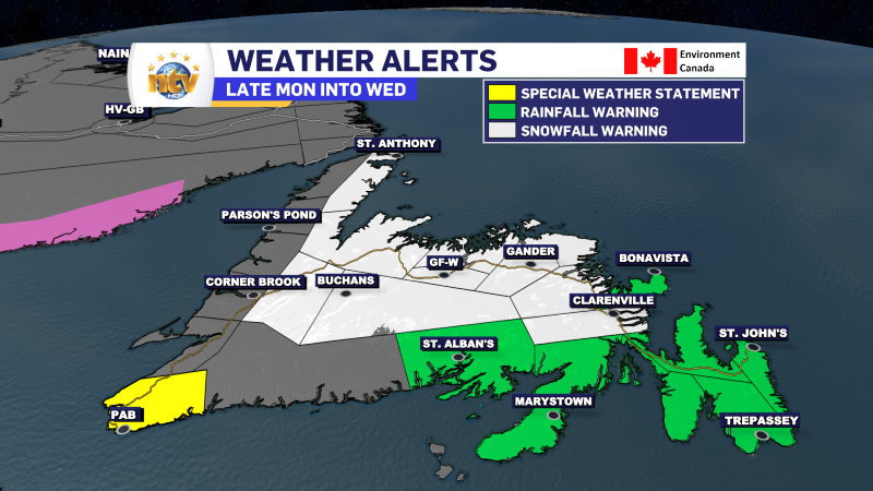
A Rainfall Warning is in effect for the following areas from this afternoon until Tuesday afternoon:
- Bonavista Peninsula
- Avlaon Peninsula North
- Avalon Peninsula Southweast
- St. John’s & vicinity
- Avalon Peninsula Southeast
- Burin Peninsula
- Connaigre
Current details: Rain, heavy at times is expected. The frozen ground has a reduced ability to absorb this rainfall.
Locations: Avalon, Burin, Connaigre, and Bonavista peninsulas.
Total rainfall: 30 to 50 mm, with locally higher amounts possible.
Time span: this afternoon until Tuesday afternoon.
Remarks: Significant runoff will likely occur as the rain combines with mild temperatures and strong winds to cause considerable melting of the snowpack from the recent winter storm. The rain is expected to mix with snow over some areas on Tuesday morning.
Be sure to clear storm drains and gutters of snow or ice. Localized flooding is possible.
Localized flooding in low-lying areas is possible.
Rainfall warnings are issued when significant rainfall is expected.
A Snowfall Warning is in effect for the following areas from this evening Tuesday night:
- Grand Falls-Windsor and vicinity
- Bay of Exploits
- Bonavista North
- Clarenville & vicinity
- Gander & vicinity
- Terra Nova
The total snowfall in these areas will be 15 to 30 cm, with locally higher amounts possibly.
A Snowfall Warning is also in effect for the following areas from this evening into Tuesday night:
- Deer Lake – Humber Valley
- Buchans and the Inteiror
- Green Bay – White Bay
- Northern Peninsula East
The total Snowfall in these areas will be 10 to 20 cm, except 30 to 50 cm over higher terrain.
Locations: northeast and east coast of Newfoundland, along the some western and northwestern areas of Newfoundland.
Time span: this evening until Tuesday night.
Remarks: The snow will be wet and heavy as temperatures hover near zero. Additionally, the snow will mix with or change to rain at times, especially over eastern Newfoundland.
Travel could become difficult. If you must travel, be prepared for delays and allow extra time to reach your destination.
Be prepared to adjust your driving with changing road conditions.
Snowfall warnings are issued when significant snowfall is expected.
A Special Weather Statement is in effect for the Channel-Port aux Basques area for late this morning until early Tuesday morning.
Current details: Elevated sea water levels are expected, possibly exceeding high astronomical tide.
Locations: Channel-Port aux Basques and vicinity.
Time span: late this morning until early Tuesday morning.
First high tide: 11.M to 1 P.M. today.
Second high tide: 11 P.M tonight to 1 A.M. Tuesday.
Remarks: Low barometric pressure will coincide with high astronomical tide to produce elevated water levels. Minor coastal flooding is possible along the shoreline.

A Wind Warning is in effect for the following areas of southern Newfoundland from this morning until this evening:
- Burin Peninsula
- Conniagre
- Burgeo – Ramea
- Channel-Port aux Basques
Current details: Strong winds that may cause damage are expected or occurring.
Maximum gusts: easterly 100 to 110 km/h along the coast.
Locations: Channel-Port aux Basques and vicinity, Burgeo – Ramea, Connaigre, and Burin Peninsula.
Time span: this morning until this evening.
Damage to buildings, such as to roof shingles and windows, may occur.
Wind warnings are issued when there is a significant risk of damaging winds.
A Wind Warning is in effect for the following areas for tonight and Tuesday:
- Avalon Peninsula North
- Avalon Peninsula Southeast
- St. John’s & vicinity
- Avalon Peninsula Southwest
- Bonavista Peninsula
- Bonavista North
Current details: Strong winds that may cause damage are expected or occurring.
Maximum gusts: easterly 80 km/h except 100 along parts of the coast.
Locations: Avalon and Bonavista peninsulas, and Bonavista North.
Time span: tonight and Tuesday.
Damage to buildings, such as to roof shingles and windows, may occur.
Wind warnings are issued when there is a significant risk of damaging winds.
-

Threat of wildfires on west coast higher this year, say forestry officials
As residents of the province prepare to head out into the woods for the Victoria…
-

Labrador West MHA wants water bomber back
With wildfires threatening Fort McMurray, Alta., again, Labrador West MHA Jordan Brown wants a water…
-

Province warns residents to be ready for forest fire season as wildfires threaten Fort McMurray
Evacuation orders and alerts remain in effect for Fort McMurray, Alta., as wildfires continue to…
