


A long-duration weather event is unfolding over the Island. An area of low pressure, a stationary boundary, and an atmospheric river are going to deliver heavy amounts of rain to southern and western Newfoundland over the next 48 hours. Rainfall warnings are still in effect as of early Tuesday morning from the South Coast (Burgeo – Ramea) and West Coast as far north as Gros Morne.

By the time we reach Thursday evening, rainfall totals over southern and western Newfoundland are going to be excessive in some areas. Some guidance suggests that nearly 400 mm may fall just inland from the South Coast and up to 200 mm will fall over the higher elevations of western Newfoundland. Flooding and road washouts are going to become more prevalent by later tomorrow and Thursday as the rain begins to fill up creeks and streams, combined with the rapidly melting snow. If you live in an area prone to flooding, it’s very important to keep an eye on water levels over the next 2 days, and be prepared to find higher ground quickly.

On top of the rain, we are going to see windy conditions for parts of western Newfoundland, southern Newfoundland, and coastal Labrador today with gusts nearing 100 km/h into this evening for many locations. Wind Warnings are up from the South Coast to the West Coast and into parts of coastal Labrador.
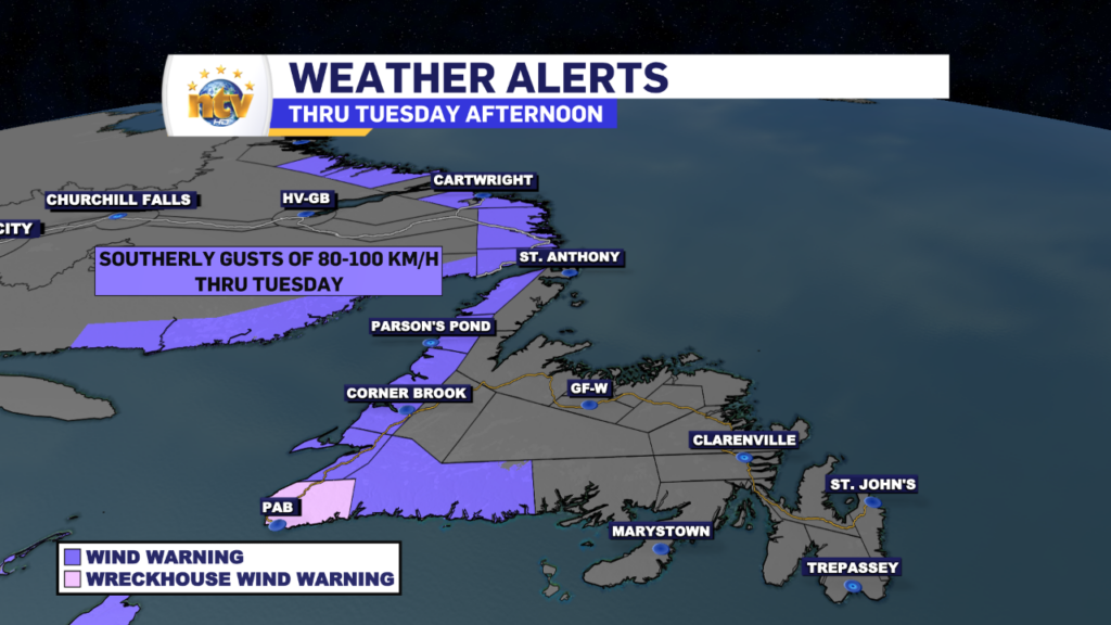
The wind speeds will generally slow down this evening as the core of the highest wind speeds rotates east of the Island and coastal sections of Labrador.
The next phase of this system will be the colder side, which moves in later Thursday through Friday. At that point, we are looking at snow and ice becoming more widespread over western and Central Newfoundland first on Thursday and then potentially eastern Newfoundland on Friday. Snow and ice amounts are going to be significant in some areas of western and central Newfoundland. I’ll have a bigger update on this later today. In the meantime, we are going to see a mild day across much of NL, with highs near 10º on the Island and single digits in Labrador.
Speaking of Labrador West, there is a flash flash-freeze warnings for the area today, as temperatures are going to plummet this afternoon

Stay tuned for further updates today!
-

Threat of wildfires on west coast higher this year, say forestry officials
As residents of the province prepare to head out into the woods for the Victoria…
-

Labrador West MHA wants water bomber back
With wildfires threatening Fort McMurray, Alta., again, Labrador West MHA Jordan Brown wants a water…
-

Province warns residents to be ready for forest fire season as wildfires threaten Fort McMurray
Evacuation orders and alerts remain in effect for Fort McMurray, Alta., as wildfires continue to…
