


RAINFALL AND WIND WARNINGS ARE CURRENTLY IN EFFECT
A strong area of low pressure is spinning well south of the Island Sunday night and is poised to bring a potent mix of rain and wind to eastern Newfoundland Monday into Monday night, or early Tuesday morning. Evening satellite imagery shows this pressure centre very well.
This area of low pressure will approach the Island late tonight and pass east of the Avlaon Monday evening, before pulling away into the North Atlantic early Tuesday morning. The track of this low will drive heavy rainfall across much of eastern and southeastern Newfoundland through the time frame, along with wind gusts to 80+ km/h Monday into Monday night over parts of the South Coast, east coast and northeast coast.
The Breakdown
THE RAIN
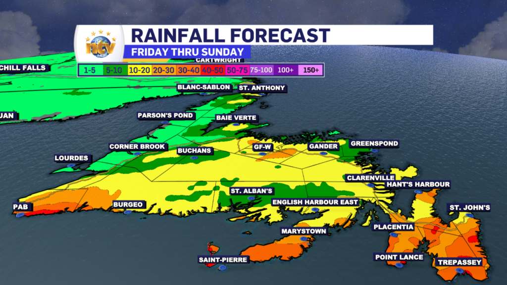
Rain will spread into southern and eastern Newfoundland between 3 AM and 6 AM on Monday. The rain will push back to the west and move about as far north as Central by 10 or 11 AM. In Central, the rain will generally be light to moderate. At the same time, areas of the South Coast, Burin, Avalon and Bonavista Peninsulas, along with the Clarenville area, will see the rain come down heavy at times during the day Monday into Monday evening. The rain will taper off late Monday night and will end from west to east over the Island by early Tuesday morning. Futurecast shows this very well, hour by hour.
Rainfall Amounts will be highest in the south and east, where upwards of 50 mm looks to fall during the day Monday into Monday night. Rainfall amounts taper off as you move westward, and away, from eastern sections of the Island.
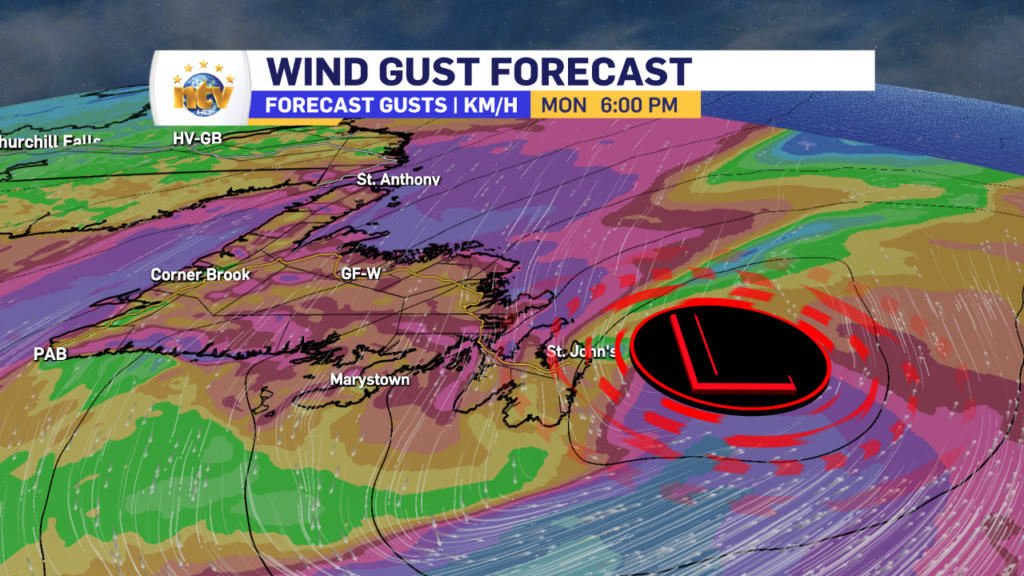
THE WIND
The winds will peak at various times over different parts of the Island on Monday, and the highest gusts will be in the 70 to 90 km/h range over exposed coastal areas. The direction of the highest gusts will generally be from the north. The first bout of high winds will be found on the South Coast and southern areas from early Monday morning through mid-day Monday. The second bout of high winds will be over the Avalon and northeast coast from Monday afternoon into early Tuesday morning. The wind speeds will ease off over all areas Monday night into Tuesday morning. Future wind gusts, below, times this out nicely for you.
I’ll have further updates for you throughout the day on Monday!
-

Hot and humid start to the weekend
The Island will see sunny skies to start today. There are a few fog patches…


