


Good Friday morning!
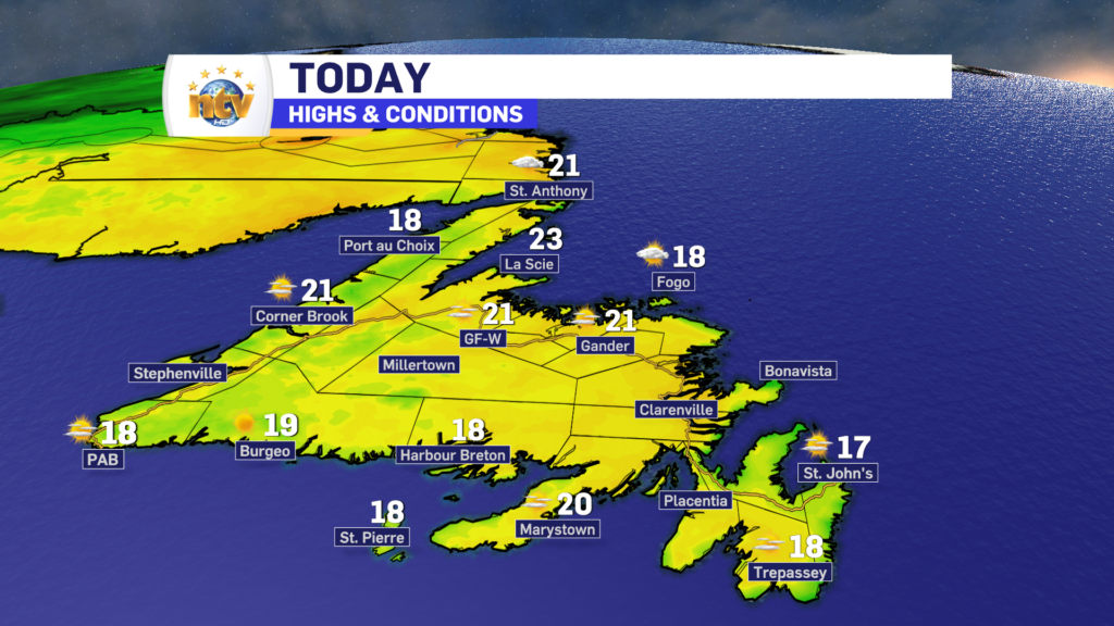
The weather across the Island today should be nicer, and calmer, than yesterday. We can expect mostly sunny, to even sunny, skies throughout the day. However… on the Avalon, it looks like the clouds will not fully clear off until later this morning. The image below is a cloud cover forecast for St. John’s. Time is on the bottom and cloud cover is on the y-axis from 0-100%. As you can see, between 8 AM and 10 AM, or a bit later, we will start to see the skies clear off.

Temperatures across the Island will peak in the upper teens to about 20º today, and overall wind speeds will be light. It will be a lovely day to close out the work week.
Meanwhile, in Labrador, rain will spread into the west throughout the day. The rain will become heavy at times this afternoon. Farther east, clouds will spill in after a sunny start. Along with that, the rain will work its way up toward the North Coast by the afternoon. Highs in the Big Land will generally be into the teens today.
Franklin Update
As of this morning, Tropical Storm Franklin is still spinning in the Atlantic north of the Caribbean Islands. The storm’s strength hasn’t changed much since yesterday and isn’t forecast to change much over the next 48 hours.

Beyond that Franklin is forecast to strengthen as it begins to move north in the western Atlantic. At this point, it is still looking like Franklin will become a Hurricane, and possibly a major hurricane (category 3 or higher) in the next couple of days, before weakening as it begins to approach the North Atlantic and subsequently Atlantic Canada.
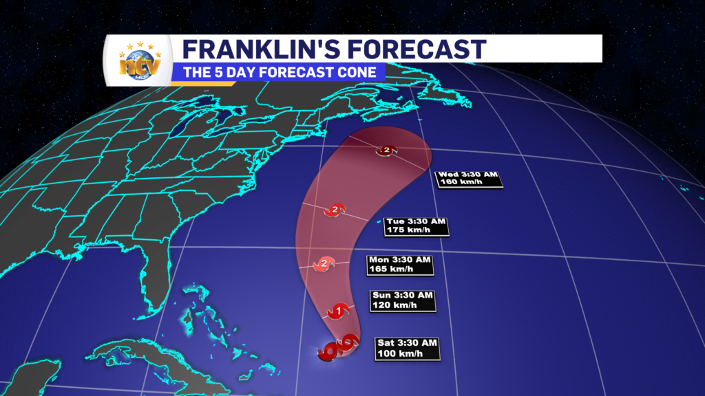
While it’s still early, it is looking like Franklin will be near the region, likely Newfoundland, during the Wednesday/Thursday time frame of next week. What impacts it brings are still a bit fuzzy, but depending on track and proximity, rain and wind are a good bet. Where the heaviest rain will be along with the highest wind speeds are not able to forecast with any accuracy. High waves and storm surge are also on the docket, but again where the storm tracks will be crucial, and at this point that kind of granularity is just not possible. It will become more clear in the next couple of days.
-
Your Latest Forecast!
Click here to visit the NTV Weather Centre to get your latest forecast!
-
Eddie’s Forecast; Some slight improvements for Friday, more noticeable this weekend
The area of low pressure that has driven all the wet weather across much of…
-

Eddie’s forecast; May starts like April ended
May starts like April ended… cold and damp for much of the Province. Eddie has…
