


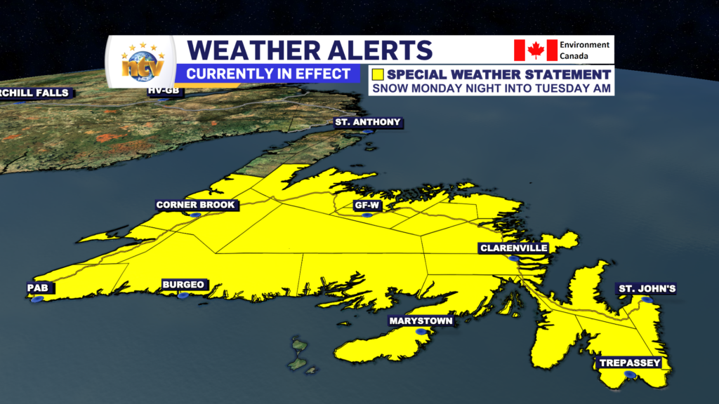
The Environment and Climate Change Canada Weather Office in Gander has issued a Special Weather Statement for the following areas:
- The Avalon Peninsula North
- The Avalon Peninsula Southwest
- St. John’s & vicinity
- The Avalon Peninsula Southwest
- The Burin Peninsula
- Connaigre
- Burgeo – Ramea
- Channel-Port aux Basques
- Corner Brook & vicinity
- Deer Lake – Humber Valley
- Gros Morne
- Bay St. George
- Buchans and the Interior
- Grand Falls-Windsor & vicinity
- Bay of Exploits
- Bonavista North
- The Bonavista Peninsula
- Clarenville & vicinity
- Gander & vicinity
- Green Bay – White Bay
- Terra Nova
The Alert reads as follows
Current details: First early-season accumulating snowfall expected for some areas.
Total snowfall: trace along the coast to 5 cm inland and over higher terrain.
Locations: all of Newfoundland except the Great Northern Peninsula.
Time span: Monday night into Tuesday.
Remarks: There has been some discrepancy among forecast guidance as to how far north the snow will reach. Some guidance keeps the snow only over the southern half of the island while others bring the snow up as far as the northeast coast. More specific details on the Monday night period will be included in subsequent forecasts later today.
For areas that get accumulating snow, surfaces such as highways, roads, walkways and parking lots may become difficult to navigate. Motorists should be prepared for winter driving conditions.
-

Threat of wildfires on west coast higher this year, say forestry officials
As residents of the province prepare to head out into the woods for the Victoria…
-

Labrador West MHA wants water bomber back
With wildfires threatening Fort McMurray, Alta., again, Labrador West MHA Jordan Brown wants a water…
-

Province warns residents to be ready for forest fire season as wildfires threaten Fort McMurray
Evacuation orders and alerts remain in effect for Fort McMurray, Alta., as wildfires continue to…
