


Good Thursday morning!
We are waking up to generally quiet conditions across much of the Province this morning, however we are seeing some showers over and near the West Coast and interior parts of Labrador. The radar loop from Marble Mountain shows showers, some heavy, approaching the West Coast at this hour (6:36 AM NDT) from Corner Brook to Daniel’s Harbour. They are heading toward the north, northeast.
The showers will be something we see over parts of western, northwest, and central Newfoundland at times today. I also cannot rule out the chance of isolated showers over eastern regions this afternoon. There will also be some scattered showers in Labrador today. Outside of that, we are looking at partly cloudy to mostly sunny skies for much of the Province.
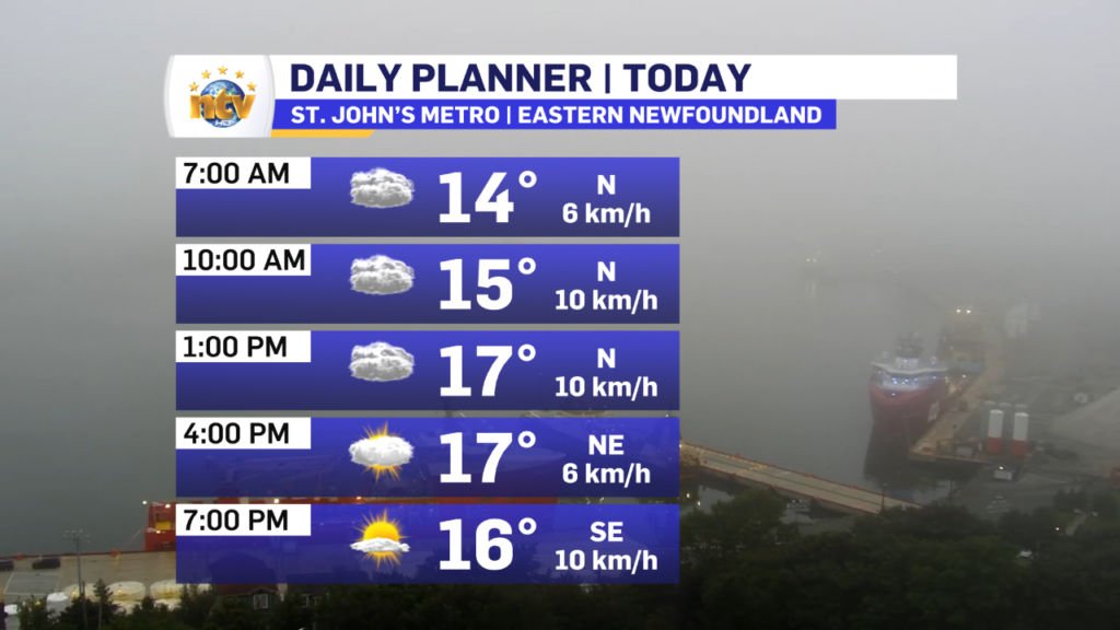
The exception will be on the Avalon, where clouds will linger into the early afternoon before clearing out after 1 or 2 PM. This evening should be large for the easternmost Peninsula! The hourly forecast shows this rather well.
Tropical Storm Franklin Update
The overnight guidance for Tropical Storm Franklin’s future track shifted considerably overnight toward the northwest, according to nearly all the computer model guidance I’m looking at this morning.
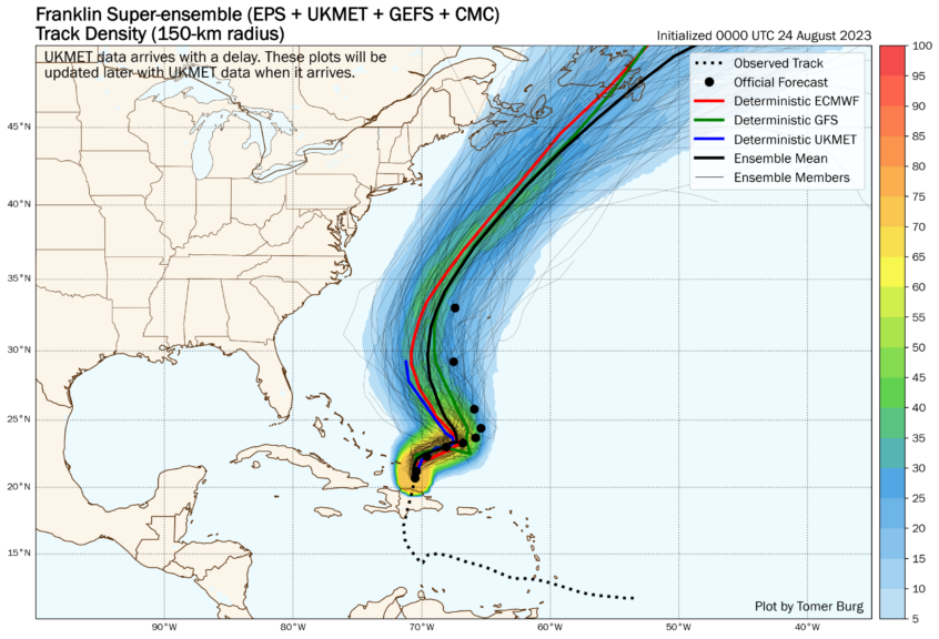
So what does this mean? It means we need to continue to pay attention to the storm and subsequent forecasts. The timing of this is still during the middle part of next week (WED/THU ) for the region.
We also need to NOT get caught up in specific details on impacts at this time. Once the storm gets moving we will see how it’s going to interact with 2 other features to its north, and at that point, we can start to identify what areas may, or may not, get x, y, and z from the storm.
Remember, this is a marathon and not a sprint. Stay tuned for more updates.
-
Your Latest Forecast!
Click here to visit the NTV Weather Centre to get your latest forecast!
-
Eddie’s Forecast; Some slight improvements for Friday, more noticeable this weekend
The area of low pressure that has driven all the wet weather across much of…
-

Eddie’s forecast; May starts like April ended
May starts like April ended… cold and damp for much of the Province. Eddie has…
