9 hours ago
Weather Forecast: Saturday, June 6
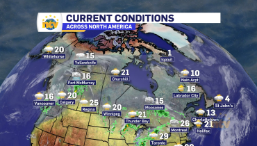
Much of Newfoundland and Labrador will enjoy warm and sunny conditions today before clouds thicken and rain spreads across several regions on Sunday. Here’s your weather forecast. St. John’s / Bonavista TodaySunny skies prevail across eastern Newfoundland. Wind becoming south 20 km/h this afternoon in St. John’s and southwest 20 km/h in Bonavista. High 16 […]
Read more