


Image above was taken by Randy Alexander at Marches Point, in the town of Cape St. George on Saturday, Marcy 30, 2024.
Heavy rainfall arrived on the Island late last week and continued into the weekend thanks to a slow-moving storm system and an atmospheric river. An atmospheric river is a narrow and elongated corridor of concentrated moisture in the atmosphere, often extending thousands of kilometers. These rivers of moisture can cause significant precipitation and are important contributors to regional water resources and weather patterns. The image in the tweet below shows that well.
Rainfall totals were impressive between Thurwsday and Saturday, and here is a list that was curated from Rodney Barney, a Meteorologist with the Environment and Climate Change Canada weather office in Gander.
- Corner Brook: 121.2 mm
- Black Duck Siding: 120.4 mm
- Stephenville: 109.2 mm
- Humber Village: 106.7 mm
- Gallants: 100.8 mm
- Deer Lake: 94.9 mm
- Lark Harbour: 92.5 mm
- Curling: 91.7 mm
- Jack Ladder: 88.3 mm
- Cormack: 88.2 mm
- La Scie: 86.8 mm
- Steady Brook: 83.8 mm
- Englee: 83.2 mm
- Daneil’s Harbour: 83.1 mm
- Point Leamington: 77.5 mm
- River of Ponds: 74.5 mm
- Pasadena: 73.1 mm
- Twillingate: 72.4 mm
- St. Albans: 70.9 mm
- Norris Point: 70.6 mm
- Rocky Harbour: 70.2 mm
- Springdale: 70.0 mm
- Birchy Narrows: 69.6 mm
- Campellton: 53.6 mm
- Port aux Basques: 45.9 mm
- Burgeo: 39.1 mm
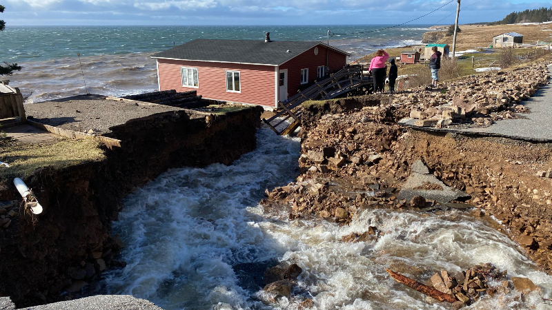
The town of Cape St. George, on the Port au Port Peninsula, experienced 2 significant washouts on Saturday. Communities along Route 460 between Rouzes Brook and Marches Point were cut off for a time. The washout at Rouzes Brook was caught on camera, showing the power of the rain.
The washout at Marches Point was less severe and has been repaired enough that it is not possible. This is what that washout looked like early Saturday morning.
There were also washouts in and around the City of Corner Brook during the rain storm, and you can find more information on that by going to our homepage as we have a couple of posts that highlight it.
On the cold side of this system, there was a significant freezing rain event in parts of the Baie Verte Peninsula. Steve Stuckless took the pictures below in the Purpecks Cove/Westport area in White Bay.
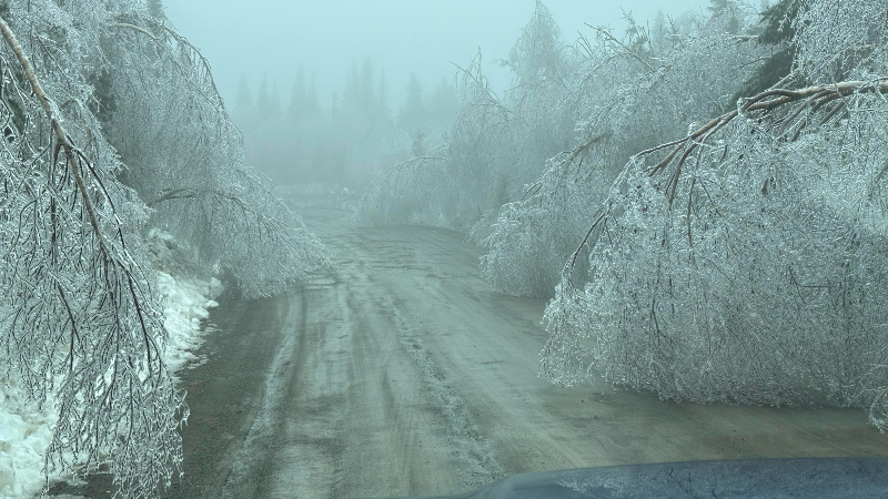

Newfoundland and Labrador Hydro is reporting there are still some outages in the area and they are currently working to restore power to affected communities. There as enough ice to bring down structures and as of early Sunday morning, the company says it will take most of the day to restore power.
The weather for Sunday will remain calmer acros the Island while parts of Labrador will see snow ongoing and/or some flurries. Looking ahead to the week, the weather looks unsettled but not super impactful. It does look like ther emay be some during the mid part of the week over parts of the Island. I’ll have an update on this for you tomorrow.
Stay safe and Happy Easter!
-

Eddie’s forecast; May starts like April ended
May starts like April ended… cold and damp for much of the Province. Eddie has…
-
Not much change in the weather for Wednesday
An area of low pressure continues to spin southeast of Newfoundland and Labrador and remains…
-
The RDF continues into Wednesday… but there are some literal bright spots in the forecast
Get all the details in Eddie’s forecast from tonight’s NTV Evening News Hour!
