


An area of low pressure is going to track through the region today and this is going to bring rain, snow, and wind with it as it does so. Over the Island, we can expect primarily rain to fall, with any mix of rain and snow over western and northwestern Newfoundland changing to rain this morning. In Labrador, much of the area will see snow, however, in the south and southeast warmer air will arrive and any snow will also change to rain this morning.
The Rain and Snow Today
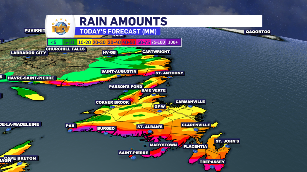
The area of low pressure is going to bring rain and snow to the region today, and it will generally be heavy at various times throughout the day. Earlier in the day the heaviest rain will be found over southern Newfoundland and later today it will be found over the Northern Peninsula to the Avalon. The heaviest rain will also fall over southern Labrador this afternoon and evening. Future Radar times this out well and should give you a good idea of what to expect.
The Wind Today
The Wind will also be quite strong at various times across the region today. Earlier in the day the wind will be strongest in the southwest and later in the day it will be strongest in the east and northwest, along with coastal areas of Labrador. This is due to the core of high wind speeds rotating across the region. The map of future wind gusts shows when the highest winds will reach your area.
Multiple areas of the Island wil see gusts nearing 100 km/h today, including the St. John’s Metro. And the wind speeds will be highest in the east this afternoon, before subsiding this evening. Batten down the hatches!
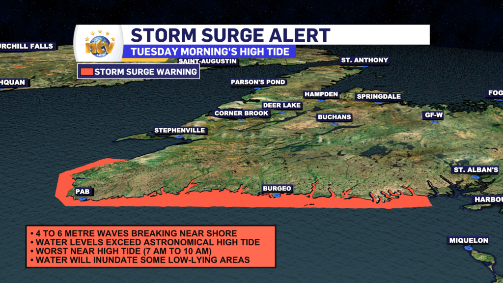
Morning Storm Surge in the Southwest
A Storm Surge warning is in effect for Burgeo-Ramea and Channel-Port aux Basques this morning. Expect high water levels is low-lying coastal locations this morning that will lead to some minor coastal flooding in some areas. Remember to keep back fro the water’s edge as the water can come up with very little warning in stations like this. The surge should retreat later this morning, after high tide, and after the highest waves depart the region, which will be after 11 AM.
The weather will generally improve this evening as this initial low-pressure centre departs the region for the North Atlantic. However, a second area of low pressure is going to develop near, or over, eastern Newfoundland tomorrow (Wednesday). And this will drive an area of heavy snowfall over the eastern half of the Island Wednesday afternoon and evening. I’ll have a more detailed update on this later today but expect travel conditions to rapidly deteriorate over the region tomorrow afternoon once the snow begins.
-
Your Latest Forecast!
Click here to visit the NTV Weather Centre to get your latest forecast!
-
Eddie’s Forecast; Some slight improvements for Friday, more noticeable this weekend
The area of low pressure that has driven all the wet weather across much of…
-

Eddie’s forecast; May starts like April ended
May starts like April ended… cold and damp for much of the Province. Eddie has…
