


Good morning! We are certainly off to a bit of a chilly start out there this morning for portions of the interior, central, and western sections of the Island.

Some of the lower valleys of interior and western Newfoundland may be seeing some fog this morning as well. That should burn off as the sun comes up and we see the temperatures starting to increase.
Wednesday will generally be sunny to mostly sunny skies across the entire Province. Highs will be in the middle to upper teens, with some areas getting close to 20°. Although skies will be clear, smoke from distant burning wildfires will be in the area and may obscure the sun. The sky will almost look milky white and the sun may appear very red due to the smoke overhead.
The Government of NL, and Environment Canada, have issued an Air Quality Alert through at least Thursday. While much of the smoke will remain aloft, some will make it down to the ground may degrade local air quality. Please follow this link for details on the alert and what that means for your health.

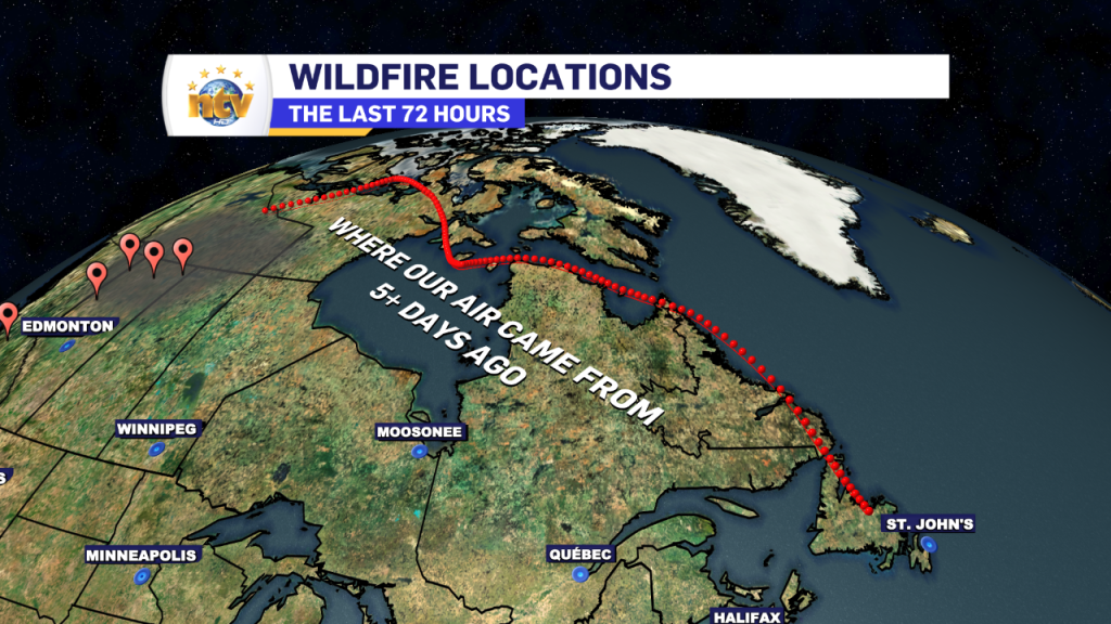
The reason for the air quality alert is smoke. Smoke burning from wildfires in Alberta, BC and the Northwest Territories has drifted across the country and due to our current weather pattern, is being directed at Atlantic Canada. The image below shows where our air originated from about 5 days ago, and this clearly shows why the smoke is here.
Due to the way air moves, especially around a high-pressure centre, which we have overheard, some of this smoke will sink through the atmosphere and reach the ground. While it is not anticipated this will cause widespread poor air quality, locally it may. Which is why the alert (link above) is in effect.
If you’re someone who has a sensitive respiratory system, please take the time to read through that alert and follow your best course of action. Reaching out to your doctor may not be a bad idea as they’ll provide you with proper medical advice on how to deal with the potential smoke.
-

Threat of wildfires on west coast higher this year, say forestry officials
As residents of the province prepare to head out into the woods for the Victoria…
-

Labrador West MHA wants water bomber back
With wildfires threatening Fort McMurray, Alta., again, Labrador West MHA Jordan Brown wants a water…
-

Province warns residents to be ready for forest fire season as wildfires threaten Fort McMurray
Evacuation orders and alerts remain in effect for Fort McMurray, Alta., as wildfires continue to…
