


Coastal flooding possible today and Thursday for southern, central and eastern Newfoundland
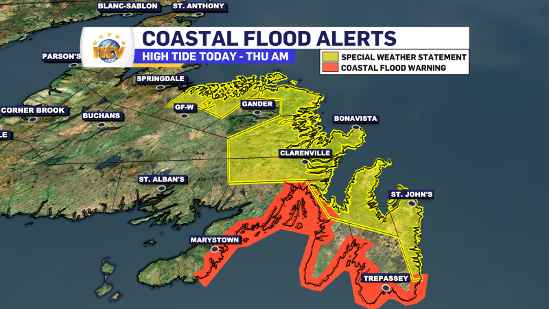
A COASTAL FLOOD WARNING is in effect from this evening until midnight for the following areas:
- Southern Coastline of the Avalon Peninsula
- Eastern and Northern Shorelines of Placentia Bay (including Ragged Islands)
- Western Shoreline of Placentia Bay
This warning is in effect for parts of the coast due to the following hazard(s): Moderate storm surge. Higher than normal water levels. Flooding is possible along the coastline. The water levels will be highest near high tide, which will occur between 5:30 PM and 7:30 PM this evening.
Winds are expected to be stronger in St. Mary’s Bay than in Placentia Bay, which will generate higher waves adding a small risk of damage to coastal infrastructure on top of the risk of flooding from storm surge.
These warnings are issued when water levels pose a flooding threat to coastal areas.
A SPECIAL WEATHER STATEMENT is in effect from near 4 AM to near 9 AM Thursday morning, due to the potential of MINOR COASTAL FLOODING for the following areas:
- St. John’s & vicinity
- Avalon Peninsula North
- Clarenville & vicinity
- Bonavista Peninsula
- Terra Nova
- Bonavista North
- Bay of Exploits
Low barometric pressure will coincide with high astronomical tide and moderate waves to produce elevated water levels. Minor coastal flooding is possible along the shorelines from Notre Dame Bay to Conception Bay.
The water levels will be highest early Thursday morning. Most significant near high tide. High tide will occur between 4:30 AM and 8:30 AM.