


Eddie’s weather blog – December 30, 2024
Post 2 – 5:55 PM NST (5:25 PM AST)
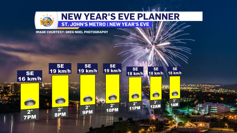
The forecast for any NYE Celebrations in the Metro looks okay… there is the chance of drizzle and fog, but beyond that, winds should be light, and conditions *should* be okay for fireworks unless the fog is too dense.
Post time – 7:11 AM NST (6:41 AM AST)
An area of low pressure is going to move from southern Ontario and Quebec toward northern Quebec today. The track of this low, being well west of Labrador, will place the entire Province on the warm side of this system. This means multiple air masses will be involved with this low pressure centre and precipitation that we see across the region will snow changing to ice pellets, freezing rain and eventually rain or just plain old rain. The wintry transition-type weather will be found in the Big Land today and Tuesday, and the simple rain will be found on the Island between later today and tonight and Tuesday.
The loop above shows you the timing of the snow (blue), ice (pink and purple), and rain moving into the Province over the next 24 hours. Ahead of this incoming weather maker there are some weather alerts in effect from the ECCC NL Weather office in Gander.
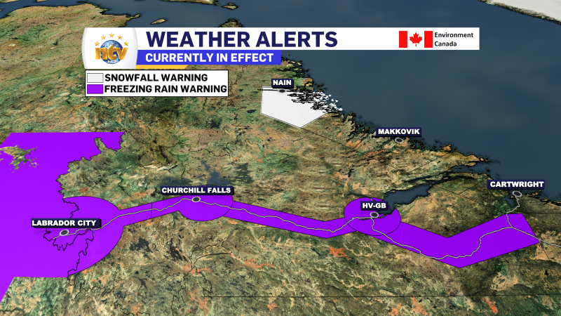
A Freezing Rain Warning is in effect from this evening until Tuesday morning for the following areas of Labrador:
- Upper Lake Melville
- Eagle River
- Churchill Valley
- Churchill Falls and vicinity
- Labrador City and Wabush
Freezing Rain amounts of 2 to 10 mm are expected over a duration of 4 to 8 hours. The freezing rain will be preceded by a period of snow and ice pellets. The intensity of the freezing rain is expected to be the strongest in westernmost Labrador but will only last roughly 4 hours. Elsewhere, freezing rain will be lighter, but could last as long as 8 hours.
Surfaces such as highways, roads, walkways and parking lots may become icy and slippery.
Freezing rain warnings are issued when rain falling in sub-zero temperatures creates ice build-up and icy surfaces.
A Snowfall Warning is in effect from Nain to Natuashish from today into Tuesday for 20 to 35 centimetres of snow.
Consider postponing non-essential travel until conditions improve. If you must travel, keep others informed of your schedule and destination and carry an emergency kit and mobile phone.
Snowfall warnings are issued when significant snowfall is expected.
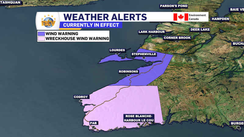
A Wind Warning is in effect for Bay St. George area from Tuesday morning until Tuesday evening for wind gusts of 70 to 100 km/h. Wind speeds will be highest in the vicinities of Cape St. George and Port au Port Bay.
A Wreckhouse Wind Warning is also in effect for the Channel-Port aux Basques areas for tonight until Tuesday morning. Maximum wind gusts will be as high as 120 km/h in the Wreckhouse area. Wreckhouse wind warnings are issued when there is a significant risk of damaging winds.