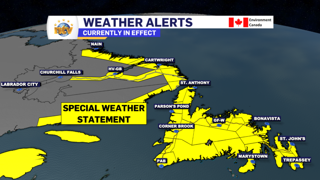
A potent area of low pressure will bring a mess of wintery weather to the Island Tuesday night and Wednesday and a full-fledged winter storm in Labrador from Wednesday afternoon through Friday. Ahead of this low, the Environment and Climate Change Canada Weather Office in Gander has issued two special weather statements; one is in effect for the Island and the other for most of Labrador.
The Special Weather Statement for the Island is in effect from overnight Tuesday night through Wednesday. Snow, blowing snow, and strong winds will develop overnight Tuesday night over southwestern Newfoundland and spread to the remainder of the island by Wednesday morning before transitioning through ice pellets and freezing rain to rain through the day. Parts of southern and eastern Newfoundland could see a period of heavy rain after the changeover but the uncertainty is still quite high on rainfall amounts at this time.
Total snowfall will generally be between 5 and 15 cm, followed by 3 to 5 hours of ice pellets and then the rain. The heaviest will likely fall over southern, central and eastern Newfoundland. Parts of the Norhtern Peninsula may not see a change to rain.
On top of that, we are looking at the potential peak wind gusts from the east and/or southeasterly of 70 to 90 km/h except up to 140 km/h in the Wreckhouse area and along parts of the west coast.
A Special Weather Statement is also in effect from Wednesday afternoon through Friday for most of Labrador, except Churchill Falls, and Labrador City and Wabush.
Heavy snow and blowing snow can be expected later Wednesday through Wednesday night from an intense winter storm passing southeast of Labrador. Snow, blowing snow, and strong winds could then persist well into Friday for many areas as the storm stalls off the southern Labrador coast.
Snowfall will be in the range of 15-30 cm, with potentially more in some areas along the coast.
Maximum wind gusts will be from the north to northwesterly at 70 to 100 km/h.
Similar storms in the past have resulted in hazardous travel conditions and road closures.
I will have full coverage of this system on NTV this evening starting at 5:30 PM and will post updated forecasts on the web as well. Stay tuned! /Eddie
-

Missing men in Happy Valley-Goose Bay located
Police have received information from the public accounting for the location of two missing men.…
-

Vigil held in St. John’s for man killed in recent car crash
A vigil was held last night in St. John’s to remember a man who was…
-
Mallard Cottage to reopen in late May
Mallard Cottage in historic Quidi Vidi Village was in the news recently facing a potential…