The Summary
FORECAST CONFIDENCE: MEDIUM-HIGH
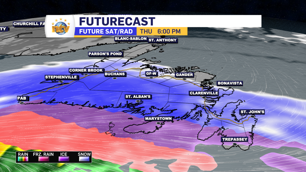
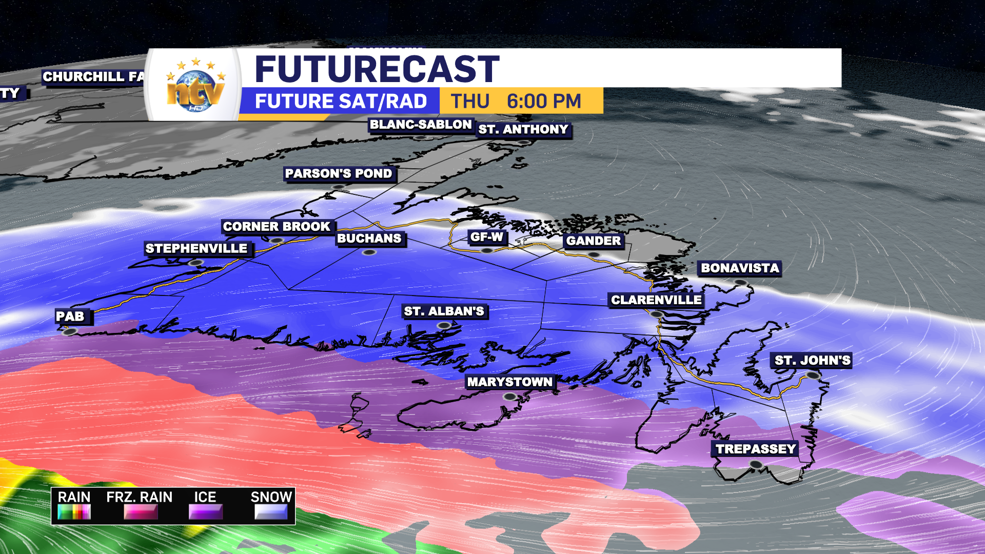
A slow-moving area of low pressure will track south of the Island between Thursday and Saturday. At the same time, an area of high pressure over Labrador will supply cold air over the Province. The combination of the two sets the stage for a long-duration, potent winter storm that will bring significant amounts of snow and ice to much of the Island beginning Thursday afternoon and lingering into Saturday morning.
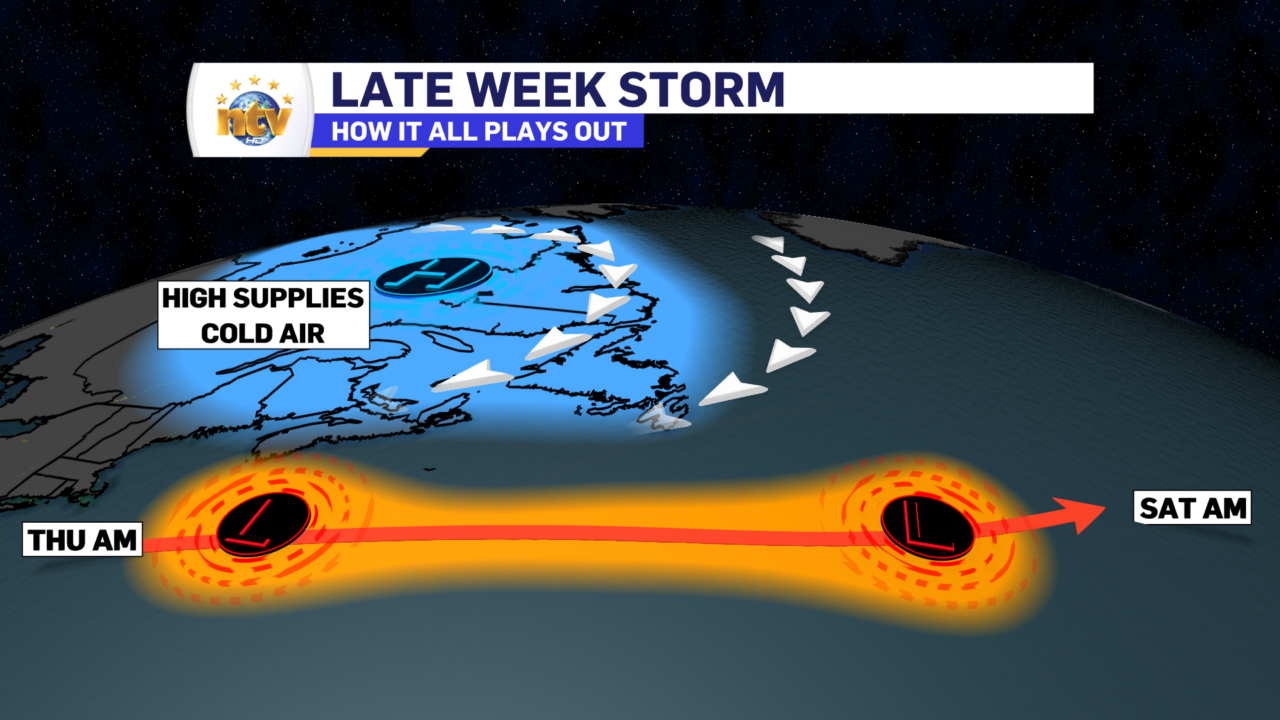
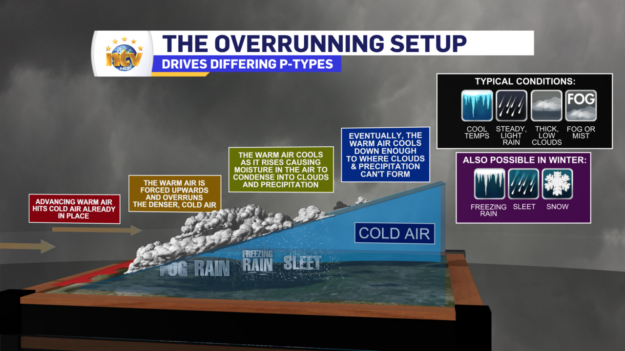
Due to their nature, lows like this often produce various precipitation types. The reason is that lows bring warm air with them and will send that warm air northward in advance of their passing. The cold air ahead of the warm air is more dense and it acts like a ramp. We call this type of precipitation overrunning precipitation. The warm air rides up and over the cold air, creating lift. The lift makes the precipitation. In this case, it will be snow, ice pellets, and freezing rain. What drives precipitation types in the winter is where the warm is, concerning the cold air in the column above a given location. Envision an Oreo. The cookie part is the cold air, and the cream part is the warm air. The thickness of the warm air (cream) determines if we get ice pellets or freezing rain. A single stuffed Orea would produce ice pellets (a small layer of warm air between the cold), and a double stuffed Oreo would produce freezing rain (a larger layer of warm air between the cold).
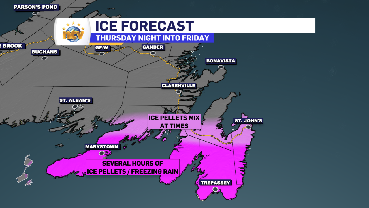
I say all that because the biggest question with this storm will be just how far north the warm air makes it in the lower to middle levels of the atmosphere Thursday night into Friday morning. As of this writing, Wednesday evening, it looks like that line will be set up near the south side of St. John’s to the northern Burin Peninsula. Areas south of this line will see the snow mix with and change to ice pellets and/or freezing rain Thursday night before going back to snow at some point Friday. And it will snow through late Friday night or Saturday morning. Areas north of that line will stay snow, and it will snow from Thursday night through Saturday morning.

What to Expect
The Environment and Climate Change Canada Weather Office in Gander has issued a Winter Storm Warning for the Avalon and Burin Peninsulas and Snowfall Warnings for areas north and west of the Burin Peninsula. You can read more about the alerts here, but areas under the Winter Storm Warning will see a combination of snow and ice. In some areas, the snow will be substantial, and areas under the snowfall warning will see snow. Areas in the Snowfall Warning will also see significant snowfall. Also, remember that the lack of an alert doesn’t mean a lack of weather; it just means the weather isn’t currently forecast to be severe enough to warrant an alert.
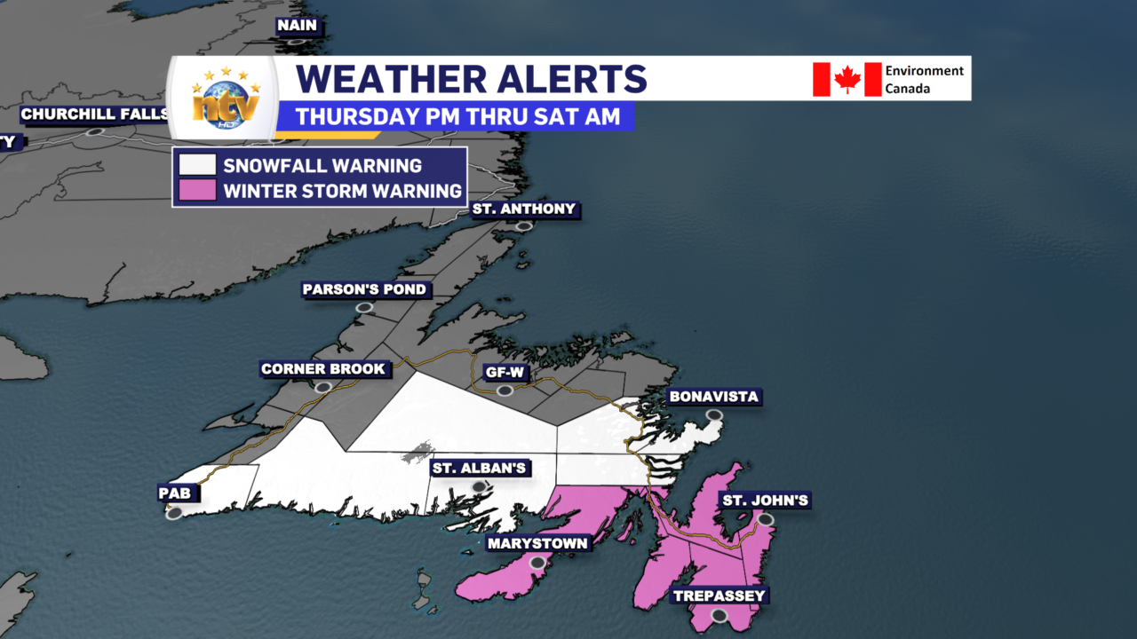
The timeline is from tomorrow afternoon or early evening into Friday or Saturday. Areas along the South Coast and into Central will see the snow Friday afternoon, while areas of the Avalon and Burin Peninsulas will see the snow end Saturday morning at some point.
Snowfall Projection
The heaviest snowfall will occur over the eastern part of the Island and likely on the Avalon Peninsula. And this will occur near, or just north of where the snow/ice pellet line sets up Thursday night into early Friday.
The snow will come in two waves. The first wave will be Thursday night into early Friday morning, and the second wave from Friday afternoon into Saturday morning. You may not be able to discern the two as the snow and ice will not stop falling, but the second wave will feature more snow over the region as we are in a cooling situation aloft and not a warming one. During those two waves, we will see the most intense snowfall rates (3-5 cm / hr).
The snowfall projection (below) outlines where I think the heaviest snow will fall based on my forecast from Wednesday. This may change as we approach the start of the storm, and subsequent forecasts may look different.

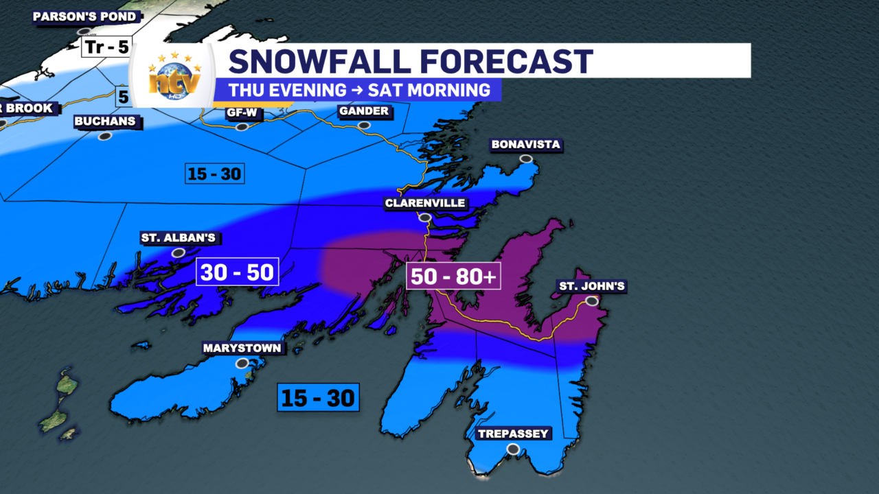
Note how the snowfall totals south of the 50-80 cm contour drop off so sharply. That’s because that area will see a significant amount of ice pellets and/or freezing rain from Thursday night into Friday morning. If that ice line moves farther north than it’s currently projected, this snowfall forecast will have to be adjusted a little bit.
Let’s Get Specific: The forecast
Thursday: Newfoundland
Snow arrives in the southwest late morning and spreads east and north throughout the day. Snow gets going in Central and eastern areas during the afternoon or early evening. Snow arrives in the Metro and northeast Avalon around 4 or 5 PM. On the Burin Peninsula and Southern Avalon, the snow will mix with ice pellets before 7 or 8 PM. Temperatures will be around -2 and wind speeds will be light.
Thursday Night: Newfoundland
The snow ends from west to east on the South Coast and through Central and will taper off before sunrise Friday. On parts of the Avalon, Burin and Bonavista Peninsulas, the snow continues, heavy at times, throughout the night. On the Burin and southern Avalon Peninsulas, ice pellets and freezing rain will fall heavily at times throughout the night. Areas of the northeast Avalon, including St. John’s, may also see ice pellets mixing in at times through the night. At this time, it’s a bit unclear just how far north the ice line will go.
Thursday: Labrador
Mostly sunny with highs of -6 to -10.
Thursday Night: Labrador
Mostly clear and cold. Lows of -17 to -26.
Friday: Newfoundland
Central and western areas, along with the south coast and Great Northern Peninsula, will be mostly cloudy. Highs in these areas will be near -3.
Snow and ice will remain on the Avalon, Burin, and Bonavista Peninsulas, along with the area around Clarenville and the Connagire Peninsula, throughout the day. The ice/snow line will sink south through the day as colder air becomes more entrenched in the region. By Friday evening, this entire region will be seeing snow, which will fall heavily at times. Temperatures will hover near -2.
Wind speeds ramp up over the eastern third of the Island Friday, with northeasterlies using as high as 60 or 70 km/h. This will create areas of blowing and drifting snow and even lower visibilities than would already be the case in falling snow.
Friday Night: Newfoundland
Snow continues on the Avalon but will begin to end to the west as the night progresses if it hasn’t already. Lows will be -2 in the east to -8 or so central and west. Winds in the east are as high as 60 from the northeast.
Friday and Friday Night: Labrador
Mostly sunny during the day with highs near -10. Chilly Friday night with lows near -20.
Saturday: Newfoundland
Snow tapers to flurries over the Avalon and should end before noon. Otherwise, expect mostly cloudy skies. Highs will be 0. Winds remain gusty, from the northeast at 40-60 km/h.
Saturday: Labrador
Partly cloudy to mostly sunny. Highs of -3 to -1.
Sunday: Newfoundland
Sun and cloud. Highs near 1 east, south and on the Northern Peninsula and 5 central and west.
Sunday: Labrador
Chance of snow. Highs of -1 to -3.
Monday: Newfoundland
Mostly cloudy, highs of 2 to 5
Monday: Labrador
Mostly cloudy in the east, chance of light snow in the west. Highs near freezing.


