Weekend weather break for Newfoundland, snow consistency shifts to coastal Labrador

Ryan Harding, NTV Weather Centre
There is a relatively small amount of snow left to go Friday on the island to close out the week, compared to what was seen accumulating in the previous 48-plus-hours.
Early morning flurries on the Northern Peninsula look to form back into some snowfall by late morning, lasting until the supper hour. Along the West Coast the snow rate is light but consistent through the morning and afternoon until clearing late Friday evening. The totals range from 5-10 cm from Corner Brook to St. Anthony, with the highest totals reserved for the top of the Northern Peninsula and along the highest elevated areas.

The 1-2 cm reflected on the Burin Peninsula and southern portion of the Avalon looks to come in the form of some on and off light flurries peppered in through out the day. Those actually come off the tail of a low-pressure system that narrowly missed the Avalon through the Thursday overnight.

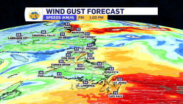
Friday for the rest of the island brings a mix of sunny breaks and cloud, the odd flurry could pass through but nothing that would accumulate. In terms of a temperature, the day will feel very similar to Thursday. Those cool west winds continue to roll through peaking at gusts of 60-80 km/h across the eastern portion of the island. Labrador West does welcome back some marginally cooler temperatures with a slight cold front creeping in.


Coastal Labrador, there’s a little more to your forecast.
Friday, at times, we have a system making two entry points from the north east – Makkovik and Cartwright. The snow actually started in Makkovik Thursday evening and is looking like it continues to fall into Sunday with little to no break. The most snow for the coast will fall Friday, extending off the coastline and into Happy-Valley Goose Bay. Totals look to gradually fall off each day heading into Sunday. The winds from Makkovik to Nain gust pretty consistently between 40-60 km/h toggling a winter storm and snow/blowing snow alert.


I always say, there isn’t much point in putting a total on something until you’re 24 hours out in this province. However, below is a 72-hour outlook on coastal Labrador and the potential incoming snow. The job Friday is to fine tune these, which you can see tonight at 5:30 on NTV’s First Edition and at 6:00 on the NTV Evening Newshour. See you there!

Related Articles