A Special Weather Statement has been issued for the following areas, highlighting winter weather late Thursday afternoon into Friday.
- Bay of Exploits
- Green Bay – White Bay
- Grand Falls-Windsor and Vicinity
- Buchans and the Interior
- Burgeo – Ramea
- Channel-Port aux Basques and Vicinity
- Bay St. George
- Corner Brook and Vicinity
- Deer Lake – Humber Valley
- Gros Morne
- Parson’s Pond – Hawke’s Bay
- Port Saunders and the Straits
- Northern Peninsula East
Discussion:
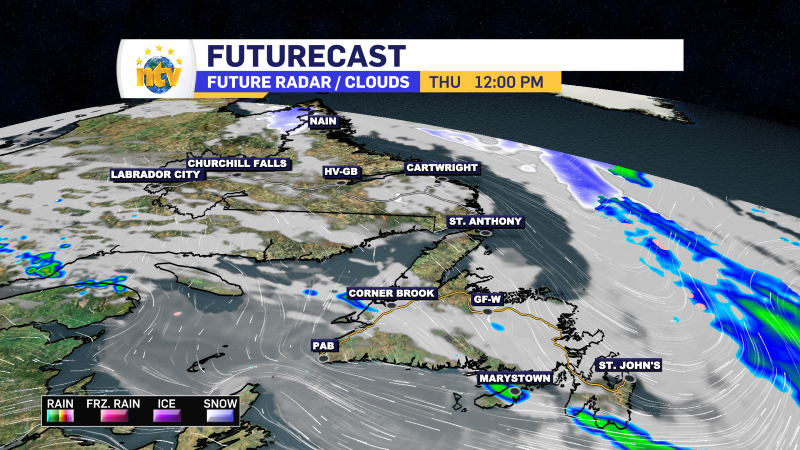
- Snow, blowing snow, and strong winds expected for the Friday morning commute.
- Locations: Western half of Newfoundland, including the Great Northern Peninsula.
- Time Span:
- Thursday night through Friday morning (except continuing all day Friday over the Great Northern Peninsula).
- Total Snowfall:
- 10 to 20 cm widespread, with up to 25 cm possible locally.
- Peak Wind Gusts:
- Southeasterly to northeasterly 70 to 110 km/h (highest along the South Coast).
- Locally 130 to 150 km/h in the Wreckhouse area and parts of the West Coast prone to enhanced downslope easterlies to southeasterlies.
- Remarks:
- Snow, blowing snow, and strong winds will develop Thursday night and continue into Friday morning before tapering to flurries or freezing drizzle from south to north.
- The snow will continue all day over the Great Northern Peninsula.
- Similar events in the past have led to:
- Traffic delays and hazardous driving conditions.
- School closures or delayed openings and cancellations of scheduled activities.
- Scattered utility outages.
- The storm system bringing these conditions will move off the northeast coast Friday night.
- Some forecast guidance suggests it will linger well into the weekend.
- If this scenario materializes, many areas will see blustery winter weather with persistent periods of snow or flurries, onshore snow squalls, blowing snow, and very strong westerly to northwesterly winds starting later Friday.
A Special Weather Statement has been issued for the following areas, highlighting winter weather late Thursday afternoon into Friday.
- St. John’s and Vicinity
- Avalon Peninsula North
- Avalon Peninsula Southeast
- Avalon Peninsula Southwest
- Clarenville and Vicinity
- Bonavista Peninsula
- Terra Nova
- Gander and Vicinity
- Bonavista North
- Burin Peninsula
- Connaigre
Discussion:
- Snow, blowing snow, and strong winds expected for the Friday morning commute.
- Locations: Eastern half of Newfoundland.
- Time Span:
- Thursday night through Friday morning.
- Total Snowfall:
- Near 10 cm widespread, with up to 15 cm possible locally.
- Peak Wind Gusts:
- Southeasterly 70 to 80 km/h, possibly reaching 100 km/h over some exposed coastal areas.
- Remarks:
- Snow, blowing snow, and strong southeasterly winds will develop Thursday night and continue into Friday morning before tapering to a brief period of rain, drizzle, or freezing drizzle towards noon Friday.
- Some areas will see a period of ice pellets and/or freezing rain Friday morning as well.
- Similar events in the past have led to:
- Traffic delays and hazardous driving conditions.
- School closures or delayed openings and cancellations of scheduled activities.
- Scattered utility outages.
- After a brief reprieve Friday afternoon, the storm system will move off the northeast coast Friday night.
- Some forecast guidance suggests it will linger well into the weekend.
- If this scenario materializes, many areas will see blustery winter weather with periods of snow or flurries, blowing snow, and very strong westerly to northwesterly winds starting Friday night.
-
NTV Weather Update | May 16, 2025
May 2-4 Long Weekend Weather Outlook: Mostly Mild and Manageable The unofficial kickoff to summer…
-
NTV Weather Update | May 14, 2025
Victoria Day Long Weekend Forecast: Tame Start, But Some Twists Ahead As we approach the…