


As of early Saturday morning snow squalls were still on going over both easter and western sections of the Island. Snow squalls are narrow bands of snow that bring intense, blizzard-like conditions to small areas for short periods of time. Occasionally a snow squall will remain over one area for a long period of time, and this can result in significant snow accumulation.
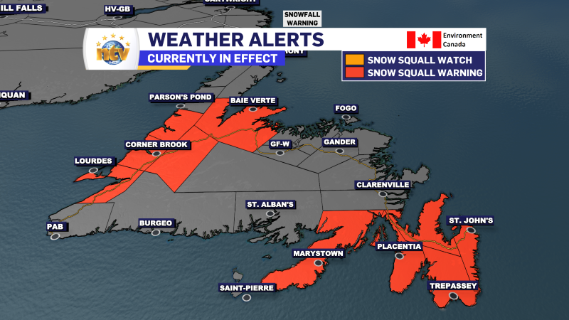
As of 6:56 AM NST, A Snow Squall Warnings are in effect for the following areas:
- The Avalon Peninsula
- The Burin Peninsula
- Green Bay – White Bay
- Gros Morne
- Deer Lake – Humber Valley
- Corner Brook & vicinity
- Bay St. George
Snow squall warnings are issued when bands of snow form that produce intense accumulating snow or near zero visibilities.
Snow squalls cause weather conditions to vary considerably; changes from clear skies to heavy snow within just a few kilometers are common. Travel may be hazardous due to sudden changes in the weather.
Snowfall totals for areas under persistent squalls will be in the 10 to 15 cm range, with locally higher amounts possible.
Wind gusts as high as 70 km/h will create areas of reduced visibility in blowing and drifting snow, especially over exposed areas.
The weather conditions driving the snow squalls will change later this morning, and at that point the squalls will come to an end.
Here are the latest alerts from Environment and Climate Change Canada
-

Hot and humid start to the weekend
The Island will see sunny skies to start today. There are a few fog patches…


