The Big Picture
An area of low pressure will intensify southeast of the Avalon Peninsula on Saturday before moving into the North Atlantic, away from the Province, on Sunday. This low promise will bring a potpourri of weather to Newfoundland later tonight and Sunday morning. Rain, snow, and wind are forecast between Friday evening and Sunday morning, although they will not all occur simultaneously.

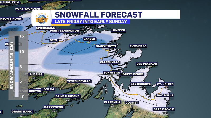
THE SNOW
Snow and rain will develop overnight along the West Coast and over interior areas of the Island. However, any snow accumulation will be limited to areas inland and over higher terrain. Travel through the Long Range Mountains will be wintry overnight. Along the West Coast, including in most towns and in the city of Corner Brook, most of what falls tonight will be rain or a rain/wet snow mix over the higher terrain.
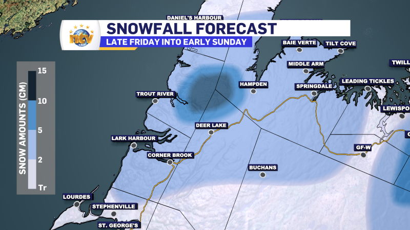
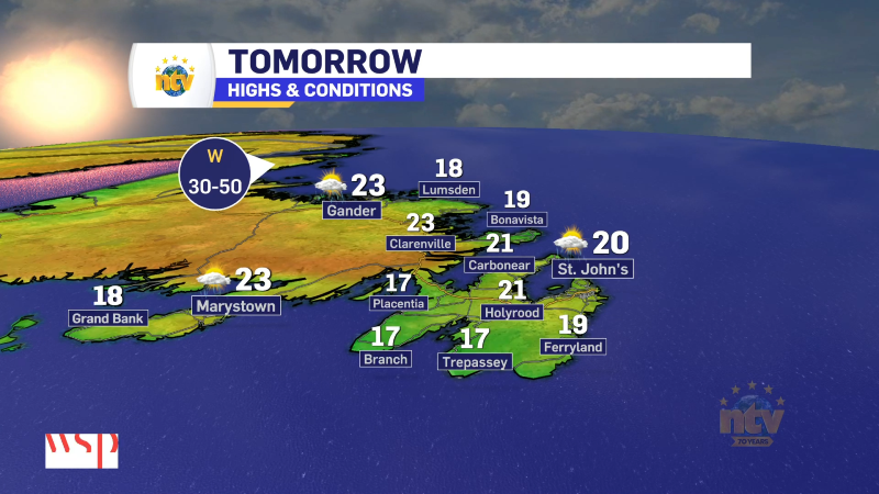
Saturday morning much of northeastern, central and western Newfoundland will be waking up to rain or a rain/wet snow mix in the higher terrain. Temperatures will be a few degrees above freezing. The wind direction will change to northerly Saturday afternoon over the area from west to east. That will signal the arrival of the cooler air and will start to the transition from rain to snow. Areas from Green Bay-White Bay to Bonavista Bay will see the rain change to snow Saturday afternoon and evening. Following that change, the snow will fly for several hours before ending late Saturday night or early Sunday morning. While I’m not anticipating signicnant snowfall, some areas will see as much 10 cm, with up to 15 cm possible in the Long Range Mouantsins by Sunday morning.
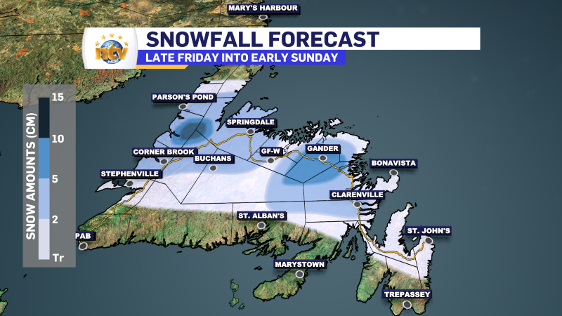
The Avalon and Bonavista Peninsulas and the Clarenville area will see rain for much of Saturday into Saturday night. Late Saturday night, the rain will mix with or change to wet snow for locations inland and over higher terrain. This may lead to as much as 2 cm in spots by Sunday morning. The snow will end Sunday morning, and for most, it will melt during the day as the sun comes out and temperatures rise above freezing.
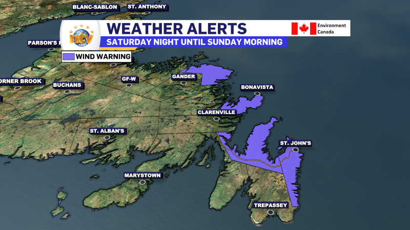
THE WIND
An area of high wind speeds will develop on the back side of the low-pressure center Saturday night and will rip across the eastern third of Newfoundland before exiting during the day Sunday. Environment and Climate Change Canada has issued a Wind Warning from Saturday night through midday Sunday. I think this will expand west and southwest.
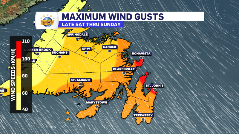
Wind gusts will be 80 to 100 km/h for many areas, with some locations seeing as high as 110 km/h. The direction will be from the northwest. And while this may not seem like a lot, consider this: the ground is not frozen, and leaves are still on the trees. This will probably lead to tree damage across much of the affected area on Saturday night and Sunday morning. There is certainly potential for some power outages as well.
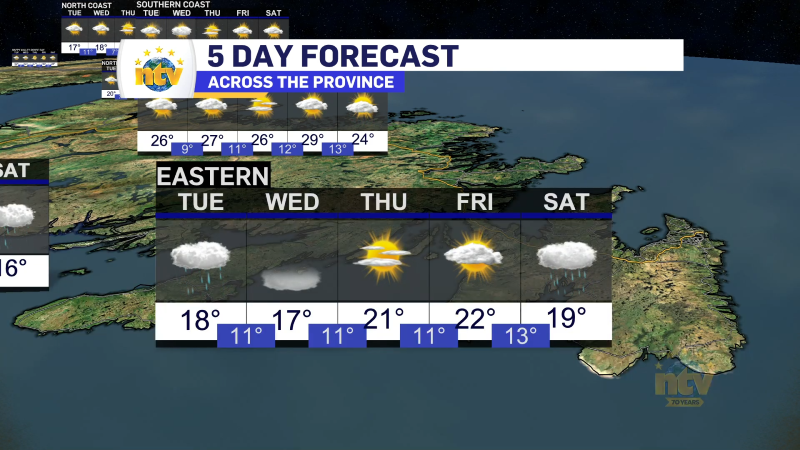
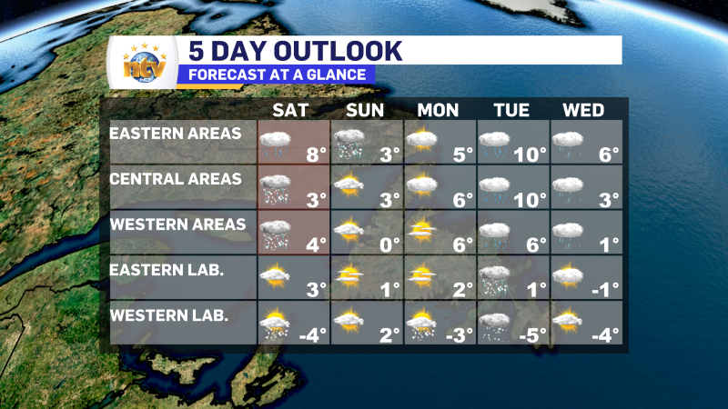
The weather will improve later Sunday, setting the stage for a calmer start to the week. The next chance of rain (Island) and snow (Big Land) will be on Tuesday/Wednesday. The five-day forecast highlights this well.
-
Nice start to the work week after some morning showers
It was a stormy weekend across Island portions of the province, with several areas seeing…