


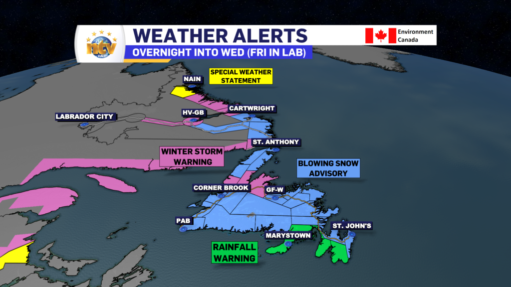
An area of low-pressure east of Atlantic City, New Jersey, is starting to spread snow, ice, and rain into Nova Scotia, New Brunswick, and PEI. That messy mix will work its way onto the Island later tonight as the area of low pressure continues moving northeast and rapidly intensifies. This low-pressure center is going to pass across the Lower North Shore of Quebec and into southeast Labrador Wednesday before eventually moving offshore Wednesday night. This track puts the Island on the messy/warm/windy side of the system and Labrador on the cold/snowy side. Some areas of coastal Labrador will also see wind, but that will hold off until Wednesday night.
Newfoundland’s Overview
TONIGHT
Snow will arrive on the South Coast around 10 PM, quickly spreading east and north overnight, reaching most areas south of the Northern Peninsula by 3 or 4 AM. The snow will fall heavily at times, and winds speeds ramping up to 50+ km/h will make for reduced visibility over exposed areas. Temperatuers will fall to between -5 and and -10 for most before the snow arrives, but then will start to rise late.
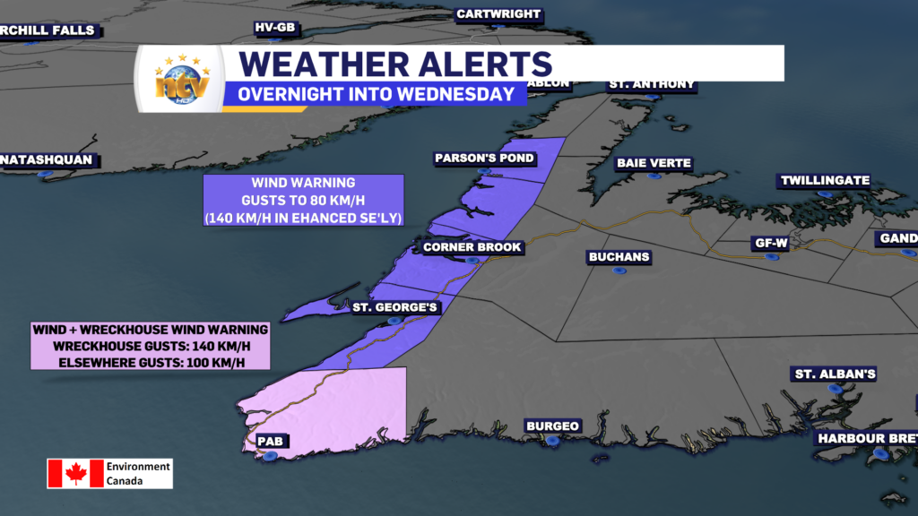
Wind speeds ramp on the West Coast and Southwest Coast late. Most areas will see gusts as high as 100 km/h. The Wrekchouse area will see gusts as high as 140 km/h. Some areas along the West Coast that are prone to enhanced southeasterlies will also see gusts to 140 km/h.
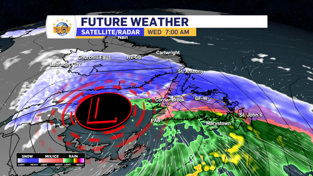
WEDNESDAY
This low will track west of Newfoundland, which means we will be exposed to the warm front and the subsequent warm air that comes with its passage. By 6 AM Wednesday, the rain/ice/snow line will work on the South Coast and southern Avalon. That line will move northward quickly and by 7 or 8 AM the Avlaon will have changed to rain, and by 10 AM areas from Central to the West Coast will have seen the snow change to ice pellets, freezing rain or rain. That line will continue lifting north and by late afternoon even the Northern Peninsula will have seen the snow change to ice pellets or drizzle. The high wind speeds will slowly decrease through the day.
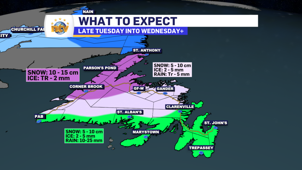
Temperatures will shoot up throughout the morning and early afternoon for most of the Island. Highs will reach as high as 8° for most. The exception will be the GNP where highs will only be as warm as 2°.
The drizzle and rain will end by late afternoon or evening for most. And the warmth will quickly be erased by a cold front. That front will move east quickly and the cold air will flood across the Island Wednesday evening. All areas will be back below freezing before midnight Wednesday night.
THURSDAY AND BEYOND
The area of low pressure driving the messy weather Wednesday will wrap up in the Labrador Sea Wednesday night and will stall near the coast through Friday before exiting Friday night. This will drive intense snow squalls across western, southern, and eastern Newfoundland from late Wednesday night through Friday. The low being there will also bring 2 days of widespread high wind speeds to the Island. Expect gusts in the 70 to 100 km/h for many areas in the time frame. The snow storms will make travel difficult in spots, especially on the West Coast and locally significant amounts are likely. The squalls will ease late Friday as the pattern relaxes. Highs on Thursday and Friday will be in the -2 to -4 range Island-wide.
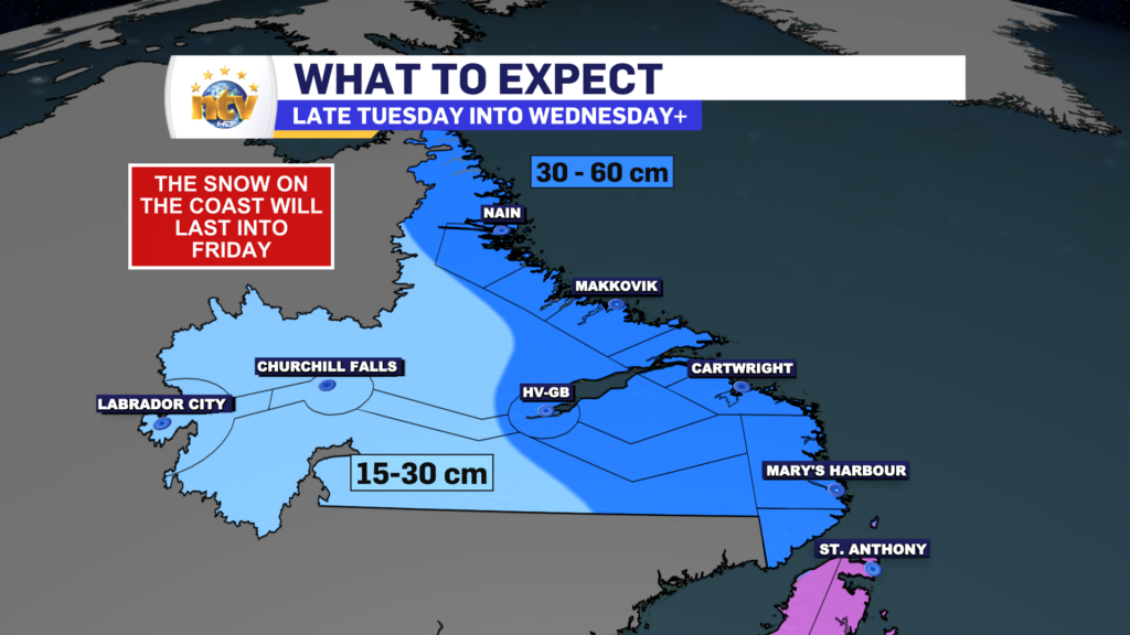
LABRADOR’S FORECAST
TONIGHT
Snow arrives in the West and will make it through Goose Bay and Eagle River and into the Straits by morning. It will come down heavy at times once it starts. Wind speeds will be as high as 20 km/h. Temperatures will be in the -15 to -20 range.
TOMORROW
Snow becomes heavy at times along the coast as the area of low pressure make its way into the North Atlantic. Wind speeds ramp up along the mid and north coast and by evening blizzard conditions will be found north of Cartwright. Highs of -1 along the coast to -14 in the west. Wind speeds as high as 60 km/h from the east on the coast and 30 km/h from the north, in the west.
THURSDAY AND BEYOND
As the area of low pressure wraps up along the coast, snow will continue along the mid and north coast through Thursday and into most of Friday before finally wrapping up Friday evening. Parts of Labrador West will also see more snow on Thursday. The weather improves for most areas Friday and for the coast late Friday night and Saturday. Parts of the coast will see blizzard conditions lingering into Friday, especially north of Rigolet. Some locations throughout the coast of Labrador, north of Cartwright, will easily see over 40 cm of snow by Friday evening.
Temperatures on Thursday and Friday will be in the minus single digits on the coast and minus teens in the west. Cold air starts to return on Saturday and Sunday as the storm departs and the continental airmass replaces the maritime one.
The weather will be much calmer for the weekend.
-

Hot and humid start to the weekend
The Island will see sunny skies to start today. There are a few fog patches…


