


A weak area of low pressure will track south of Atlantic Canada today and tonight and will bring light to moderate snow to southern and eastern Newfoundland as it does so. This is the same area of low pressure I talked about last week, but the timing shifted from 12 to 18 hours from what it looked like last Friday.
Timing of the snow
The Holyrood Doppler Weather Radar is currently out of service, so pinpointing where the snow is and when it will start/end will be a challenge once more.
Based on current model projections, the snow is set to arrive in southern areas of the Island this morning between 9 and 10 AM and then will spread northward to a point. The snow will spread across the Burin and Avalon Peninsulas between 10 AM and noon. The most intense snowfall (1-2 cm per hour) looks to be this afternoon into the early evening. The snow will then end from west to east and north to south between this evening and early Tuesday morning.
The snow will first end on the South Coast, then on the Burin Peninsula, and last on the Avalon Peninsula and parts of the Bonavista Peninsula and northeast coast. The Bonavista Peninsula will mainly see its snowfall tonight. Areas west of the eastern side of Bonavista Bay will not see much if any, snowfall overnight. Or so that’s how it looks.
Future Radar does a great job of showing how this all plays out today. You can watch a few times to get the timing down for your particular area. If you’re unsure where you are on this map, visit google maps, enter your location, pick a landmark, and go from there.
Snowfall Amounts
Snow amounts will be light to moderate by the time Tuesday morning rolls around. The highest amounts will fall over the southeast Avalon, where close to 20 cm is possible. I expect 10-15 cm to fall closer to the St. John’s Metro, with higher amounts in the higher terrain and over inland locations. Lower-end amounts will be found around much of CBS.
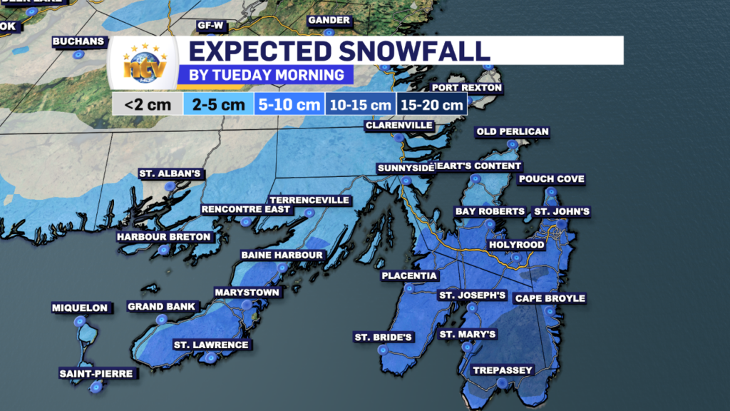
Farther west and across the rest of the Island, I only expect low-end amounts of 5 cm or less along the South Coast, parts of eastern Newfoundland just west of the Avalon, and north of the Bonavista Peninsula.
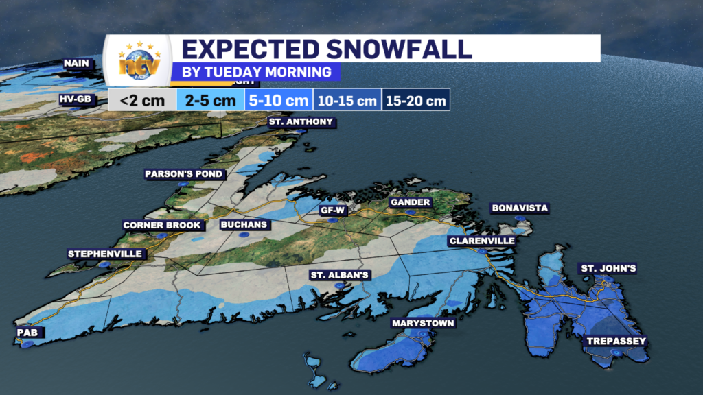
Once west of, let’s say, Eastport, I wouldn’t expect much snow to fall. Some areas of the Baie Verte and Northern Peninsula will also see some snow, but that looks more to do with onshore flow and less to do with the area of low-pressure skirting to our south.
Will it be Stormy?
Wind speeds will generally be in the 20-40 km/h range from the north, so at times, it may be a bit stormy, especially in exposed areas this afternoon and evening. However, temperatures near freezing and the lack of truly heavy snowfall should keep it from getting too bad out there.
Roads will remain passable but will be snow-covered. We’ve dealt with this before. Please slow down, take your time, and use your best judgment on whether you think travel’s safe. But this isn’t a blizzard, and no weather alerts are currently in place.
-

Hot and humid start to the weekend
The Island will see sunny skies to start today. There are a few fog patches…


