


The Overview
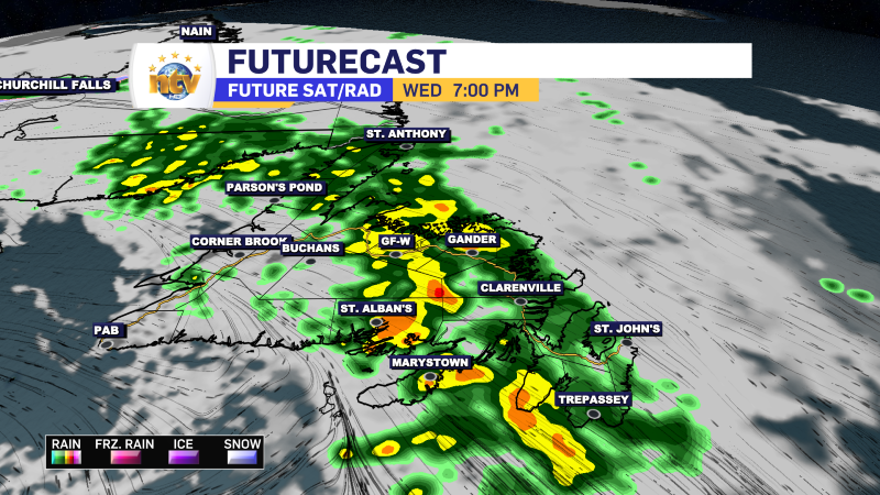
An area of low pressure will slowly move from the western Gulf of St. Lawrence through Labrador during the next 24 hours. The low is going to bring rain and some wet snow in Labrador and rain over the Island during the time frame. The rain on the Island has already arrived on the West Coast and will move to the east this evening and tonight. The rain will end on the West Coast this evening but will continue on the Northern Peninsula, Central, the Northeast, and the Avalon and Burin Peninsulas overnight. Labrador will also see rain overnight, mixed with wet snow in the higher terrain.
The rain many of us see on the Island is along a cold front. That cold front will slow down near the Avalon overnight and Thursday. Along that front, there will be a fairly persistent area of heavy rainfall that will continue throughout Thursday. Most computer models suggest that the front will hang just offshore of the Avalon’s east coast, keeping the rain offshore. However, if that placement is a bit wrong, the heavy rain will fall over the eastern Avalon. Unfortunately, I will not know if this is the case until the rain falls on Thursday. The predicted rainfall forecast
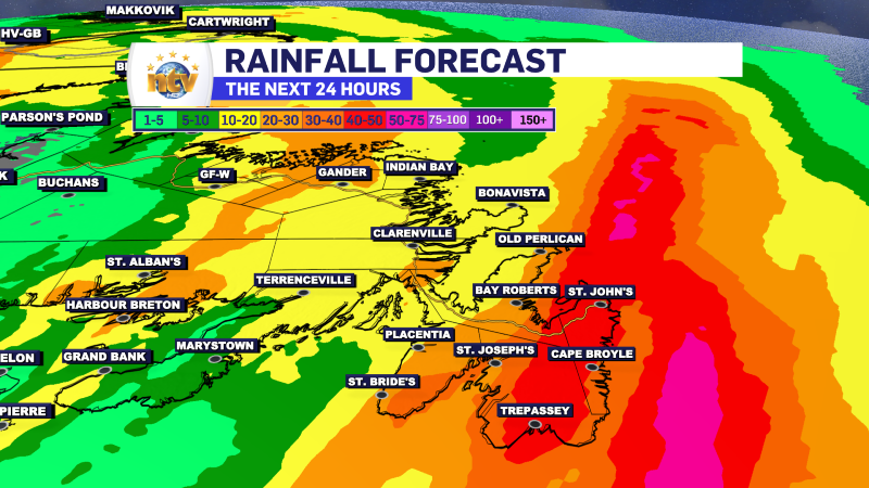
As you can see, the area of heavy rainfall is a bit farther east than yesterday. But it would only take a small shift to have that rain fall over the eastern side of the Avalon.
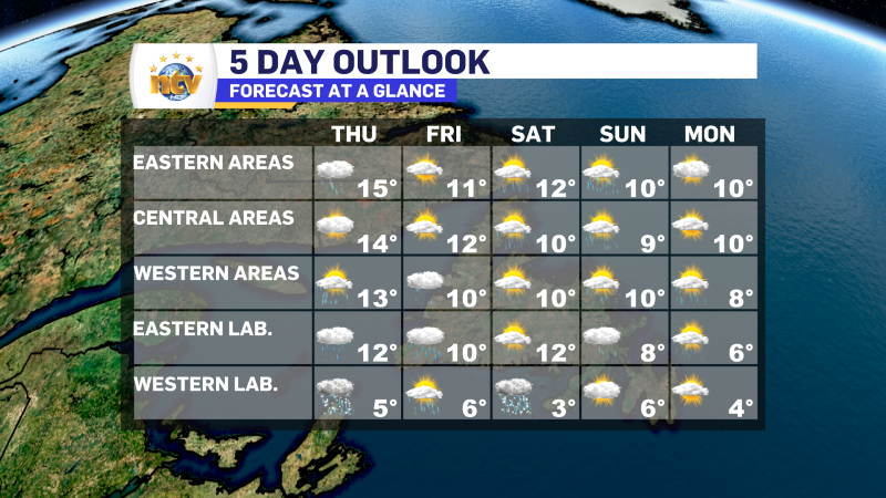
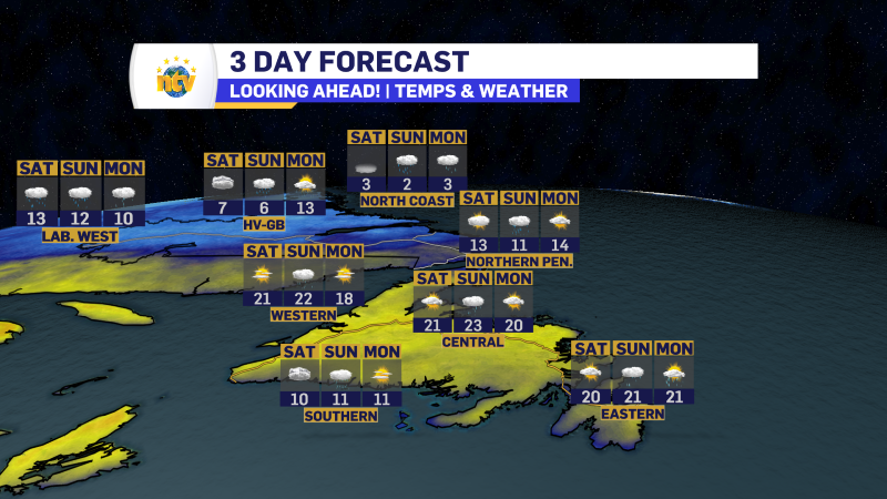
Newfoundland’s Forecast
Tonight
Periods of rain over most of the Island, heavy at times in the east. The West Coast will see clearing as will the southwest coast.
- Lows of 6 near the West Coast
- Lows near 10 south/central and northeast
- Lows near 12 on the Avalon
Thursday
Periods of rain on the Avalon Peninsula, with generally a mix of sun and cloud to the west. There will be a few showers on and near the West Coast.
- Highs in the lower to middle teens
Friday
Scattered showers Island-wide, but most numerous on the West Coast. Mostly cloudy.
- Highs of 10 to 12
Saturday
Scattered showers, most numerous on the West Coast. Mostly cloudy.
- Highs of 10 to 12
Sunday
Scattered showers, most numerous near the West Coast. Mostly cloudy.
- Highs near 10
Monday
Sun and cloud across the Island.
- Highs near 10
Labrador’s Forecast
Tonight
Periods of rain across the board. Areas of the West and Churchill Falls will see some wet snow mixing in with the rain at times.
- Lows near 5 on the coast and 1 to 3 in the west
Thursday
Showers in the west and north. Scattered in the east and southeast under mostly cloudy skies.
- Highs of 5 to 10
Friday
Periods of rain and showers.
- Highs of 6 west to 10 in the east
Saturday
Showers and flurries in the west under partly to mostly cloudy skies. Scattered showers on the coast under mostly cloudy skies.
- Highs near 3 in the west and lower teens on the coast
Sunday
Showers on the coast and sun and cloud in the west.
- Highs near 7
Monday
Scattered showers in the east, with a mix of sun and cloud in the east.
- Highs near 5
-
NTV Weather Update | May 30, 2025
Last updated May 31, 2025 at 8:11 AM Saturday – Newfoundland Sun and cloud with…
-
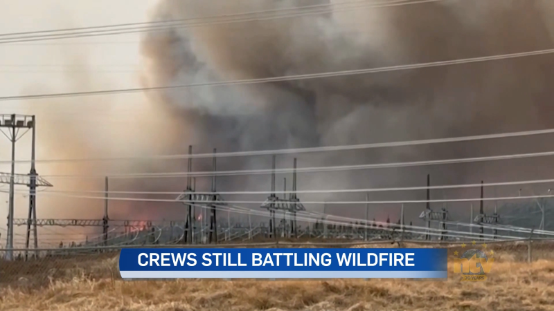
Labrador residents feel some relief as wildfire conditions improve
Residents in Labrador are feeling some relief today as conditions improve for crews battling the…
-
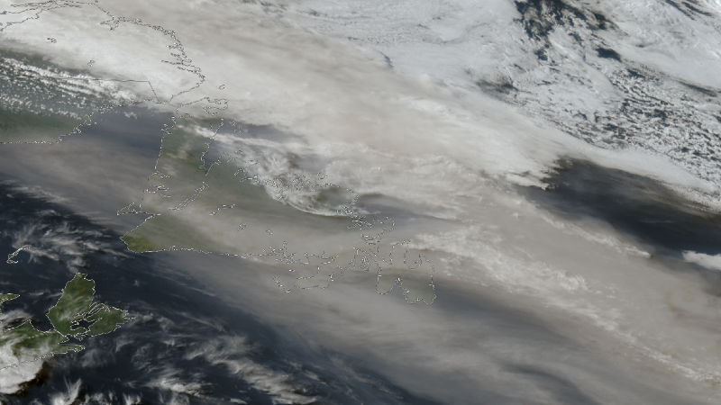
NTV Weather Update | May 29, 2025
The haze across Newfoundland today created some beautiful scenes — we received several photos of…
