


The weather across the Province today will generally be quiet, cold, and breezy under partly cloudy to mostly sunny skies. There will be some exceptions to the rule, like on the West Coast and over parts of the South Coast, where flurries will be fairly consistent. Highs across the region today will range from the minus teens in Labrador to minus single digits over the Island. Winds will gust as high as 60 km/h, which will push wind chills into the minus teens.
The weather tomorrow also looks very similar to today, with perhaps less wind and more sunshine. Temperatures will be similar, if not a couple of ticks cooler in some areas.
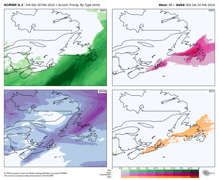
The next weather maker arrives Thursday afternoon, and here are the Coles notes on that one:
- Snow arrives late afternoon on the Burin and Avalon Peninsulas.
- The snow will quickly change to freezing rain and rain Thursday evening/night.
- There may be a prolonged period of freezing rain for some parts of the Avalon on Thursday night.
- Snow arrives in eastern Newfoundland (west) of the Avalon Thursday night and will also transition to freezing rain or rain.
- Central will see snow and/or freezing rain on Friday, ending in the afternoon.
- There is the potential for a narrow area of heavy ice accretion somewhere in Central or eastern Newfoundland west of the Avalon Thursday night and Friday.
- The West Coast will see snow on Friday, ending in the afternoon.
At this point, it’s a little too early to get into amounts of snow and ice, but it will be significant in some areas. I’ll have more info on this for you later today.
-

Hot and humid start to the weekend
The Island will see sunny skies to start today. There are a few fog patches…


