The image above taken by Trude Roul in Lawn, NL
Tonight’s Forecast
The weather across Newfoundland and Labrador tonight will be on the quiet side of the spectrum. On the Island, we can expect mostly clear skies and lows as low as -15 in Central. Most other areas will be in the – 5 to -10 range overnight. Labrador will see a mix of partly cloudy skies in the east and cloudy skies in the west. Some flurries will arrive in the West overnight and the north very late tonight or early Thursday morning.

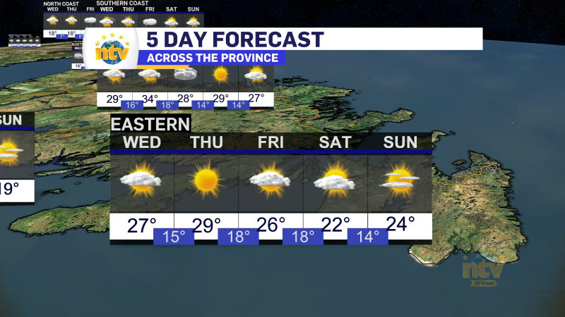
Thursday’s Forecast
The day will start off quietly and sunny across the Island. Clouds will start to arrive late morning in the south and east, followed by snow late in the afternoon or evening for the same areas. Areas of Central, Western, and the Great Northern Peninsula will see any precipitation holding off until Thursday night. Highs will be in the -1 to -3 range. Meanwhile, Labrador will see partly cloudy skies in the east and southeast and flurries and/or light snow in the north and west. Highs will be as low as -13 in the north, but generally in the single digits below freezing farther south and west.

Incoming Weather Maker
The next low will push its moisture onto the Island in the afternoon. As it looks now, snow will arrive over the Burin and Southern Avalon Peninsulas between 1 and 2 PM. In the Metro and over the Avalon North, snow will arrive between 3 and 4 PM. The snow will intensify in these areas but, after a few hours, will change to freezing rain. The freezing rain will last for several hours over parts of the Avalon and Bonavista Peninsulas on Thursday night. Some areas of the Avalon, mainly the southeast, southwest, and St. John’s, should change to rain at some point Thursday night or early Friday morning. The freezing rain and/or rain will end early Friday morning. The Bonavista Peninsula will also see the snow change to freezing rain on Thursday night. At this point, there is still some disagreement about how much rain vs. freezing rain the Avalon North and the St. John’s Metro will see. It’s this area that *should* see a change to rain, like these southern Avalon, but many not.

For areas that remain freezing rain for a long period Thursday night, there will be significant ice buildup on trees, powerlines, and some elevated surfaces. All surfaces will become slippery. There is also the risk of power outages due to the ice accretion on trees and power lines.

At this point, I do not think power outages will be widespread, but they are possible. Epsieclaly over the Avaon North, the Bonavista Peninsula and the Burin Peninsula.
To the west of that area, about as far west as Deer Lake on the West Coast and Port aux Basques on the South Coast, we are looking at snow from tomorrow evening into Friday morning. Amounts will be highest from near Connaigre to Terra Nova and Bonavista Bay. We are looking at 15-20 cm in this area. To the east of there, we are looking at less because of the change to freezing rain. And to the west, we are looking at less due to being outside of the heaviest snow band.
The weather improves quickly on Friday morning as the low pulls away. Friday looks quiet across much of the Province behind the departing low. The next low moves in Saturday, bringing rain to the West Coast and Southwest Coast and a push of warm air. There may be significant amounts in the southeast, and subsequently, there will be the risk of flooding from the warm temperatures, the rain, and melting snow. Temperatures will dip back below freezing on Sunday and Monday.
-

Unsettled for most of the province today
There will be a risk of some morning showers along the west coast of the…