Post 2 – 6:57 PM NST (6:27 PM AST)
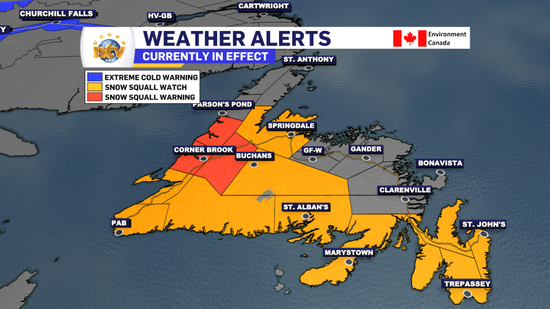
Snow squalls have continued throughout the day over much of western, southern, and eastern Newfoundland. They’ve been most intense on the West Coast, where Snow Squall Warnings are in effect.
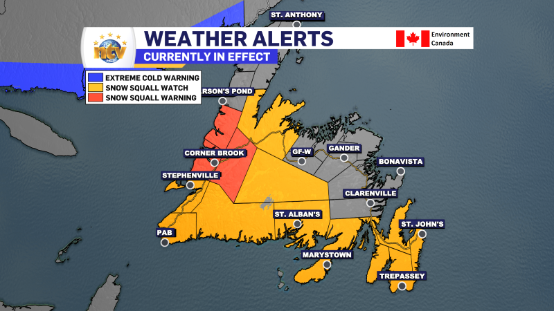
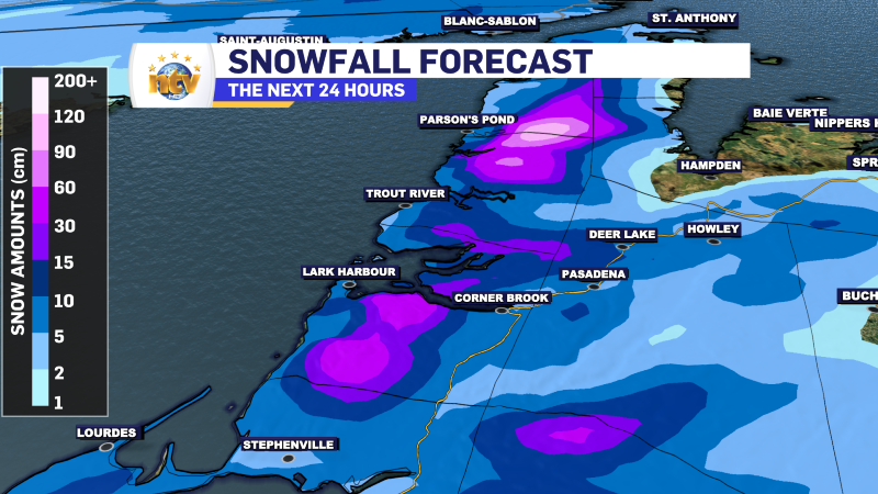
Areas under the most intense and prolonged snow squalls have seen significant snow. This includes much of the West Coast, including Corner Brook and Deer Lake.
Snow Squall Watches are issued when snow squalls are possible, and warnings are issued when snow squalls will reduce visibility to less than 400 meters for 3 hours or more, or snow amounts will be 15 cm or more in 12 hours or less. If that criterion is not met, the watch will not be upgraded to a warning even if snow squalls have developed.
The squalls will continue overnight and over much of western, southern, and eastern Newfoundland through Wednesday. Amounts will vary but will total more than 20 cm in some areas under the most persistent squalls.

While the snowfall amounts over eastern regions are less certain from the squalls, it does look like we will see some light snowfall over the Burin and Avalon Peninsluas late tonight into Wednesday morning. Looks like a widespread 2 to 5 or 5 to 10 cm is coming. Higher amounts will be found south, and locally, higher amounts will be found in areas that see snow squalls overnight and on Wednesday,

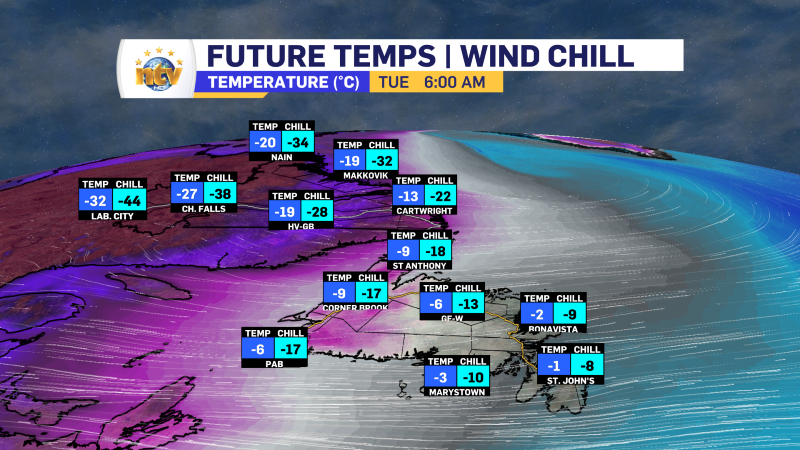
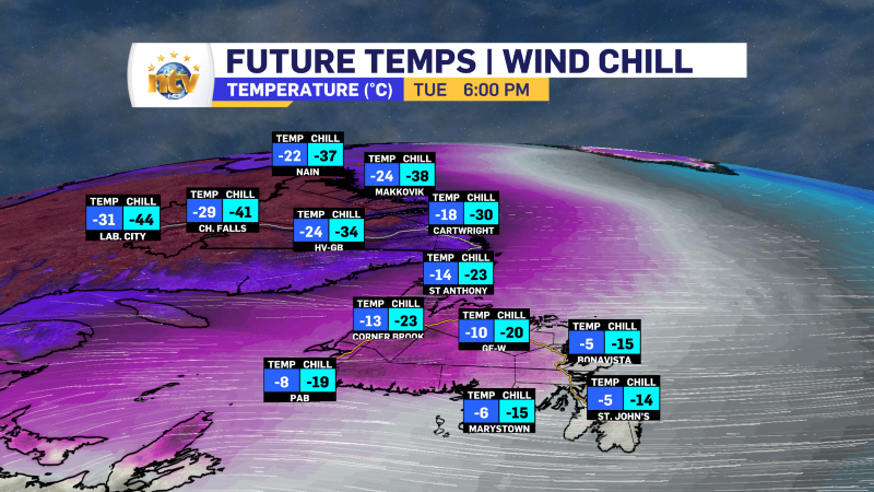
An Extreme Cold Warning is also in effect for Labrador West into Wednesday morning for wind chills as low as -50. Frostbit can set in with minutes when wind chills are that low. Air temperatures will fall into the -30s.

Temperatures overnight and tomorrow will stay cold across the Province, with lows tonight in the -20s and -30s in the Big Land and highs tomorrow in the -10s and -20s. On the Island lows will be in the minsu single digits to minus teens overnight, and highs will not move be that much different tomorrow. Wind chills be into the minus teens and 20s.
Post 1 – 6:00 AM NST (5:30 AM AST)
Good morning!
Arctic air has moved across the Province overnight and continues to move in this morning. Temperatures are in the single digits below freezing over eastern Newfoundland, while western areas are closer to -10º. Labrador is seeing readings in the minus 20s and minus 30s this morning, with wind chills even colder. An Extreme Cold Warning is in effect for the Churchill Valley, Churchill Falls, Labrador City, and Wabush for wind chills as low as -50 this morning!
Temperatures will not move much today… Readings will hold steady for fall in most areas as the cold piles in. The good news is that even though it will be cold today, there should be plenty of sun outside the snow squalls. Although, it will be breezy, with winds across the board gusting to 70 km/h.
Snow squalls have developed overnight across the West Coast, South Coast, Burin Peninsula and Avalon Peninsula and will become more widespread and intense throughout the day. Snow squalls are intense, short-lived bursts of heavy snowfall accompanied by strong winds, causing sudden drops in visibility and potentially hazardous travel conditions. They often develop quickly, resulting in whiteout conditions and rapid snow accumulation. Generally, snow squalls will not sit over one location for an extended period, but today is a day when that will happen in some areas. In these squalls, expect low visibility, heavy snow, blowing snow, and wind gusts to 70 km/h; essentially blizzard conditions.
Snow Squall Watches and Warnings are in effect for the West Coast, South Coast, Burin and Avalon Peninsulas, along with Buchans and the interior and Green Bay – White Bay. The ‘watch’ areas may become warning areas at any time, as the squalls move through. We will likely see the alerts flipping between watches and warnings today.
While it is easy to predict snow squalls, it’s more challenging to say how much snow they can drop over a given area… but areas that end up in a squall for a prolonged period will see snowfall in excess of 15 cm. The mountains will see heavy snowfall today and for the next few days. The amounts will total nearly 100 cm of new snow by the end of the week. That is excellent news for those who love bringing your snowmobiles into the backcountry. Please do so cautiously!
More updates to come throughout the day!
-

Hot weather continues across the province
It will be another nice day across the Island portion of the province with a…