The cutoff low that brought all the soggy weather to much of the Island this weekend isn’t going anywhere fast as we start the new week. Eastern sections of the Island will be stuck in the rain, drizzle, and fog. Areas to the west may not be quite as rainy or foggy. Very few areas of the Island will see sunny skies for the next few days.

This low has brought significant rain totals to various areas of the Island so far and promises to do more of that over the next couple of days.
This will be especially true Tuesday night into Wednesday when another round of heavy rain is going to roll in for the eastern third of the Island. Before then, it’s status-quo… onshore, easterly flow with rain, drizzle, and fog for east-facing shores.
The Forecast
Monday
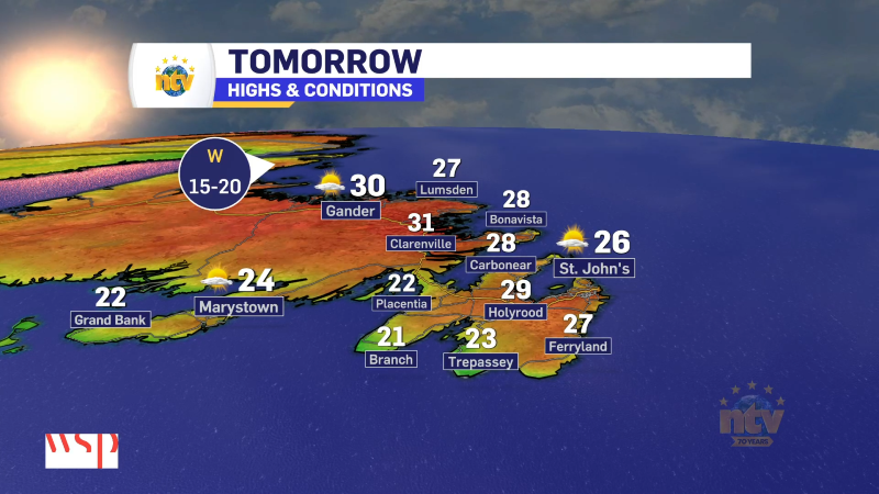
Another day of light to moderate rain is likely for eastern areas. However, this may be a day where east-facing shores take the brunt. Monday has the look of CBS being decent and East End being socked in and drizzly. Areas of Central, the South Coast, the West Coast, and GNP will sometimes see some sunny breaks. Highs of 9 east, 16 central, and 18 south and west.
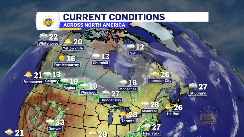
Labrador will be mostly cloudy. Highs in the lower 20s.
Tuesday and Wednesday
It looks quiet across the region, with less rain and less cloud cover. However, at this point, I don’t expect a drastic improvement in the weather. Highs on the Island will be in the teens to near 20 (coolest east), and highs in Larador will be in the lower to middle 20s.

-
Hot weather continues across the province
It will be another nice day across the Island portion of the province with a…