


A slow-moving area of low pressure brought significant rainfall to much of Newfoundland between Thursday night and Saturday morning. Several communities experienced substantial localized flooding as a result.
The following is a summary of rainfall amounts received by the Environment an Climate Change Canada Weather Office in Gander as of 5 PM Saturday (October 26, 2024):
- North Harbour (Placentia Bay): 191.4 mm
- Noel Paul’s Brook (Exploits Rier): 139.2 mm
- Marystown: 129.3 mm
- Head of Bay D’Espoir: 122.2 mm
- Clarenville: 116.1 mm
- Beothuk Lake: 114.8 mm
- Burin Bay Arm: 114.1 mm
- Millertown: 113.0 mm
- St. Albans: 107.9 mm
- Badger: 105.3 mm
- Winterland: 91.4 mm
- St. Lawrence: 91.3 mm
- Terra Nova National Park: 80.5 mm
- La Scie: 78.6 mm
- Grand Falls-Windsor: 69.3 mm
- Burgeo: 64.4 mm
- Gander International Airport: 63.6 mm
- Argentia: 53.3 mm
- St. John’s West: 53.1 mm
- Bonavista: 52.3 mm
- St. John’s International Airport: 49.6 mm
-
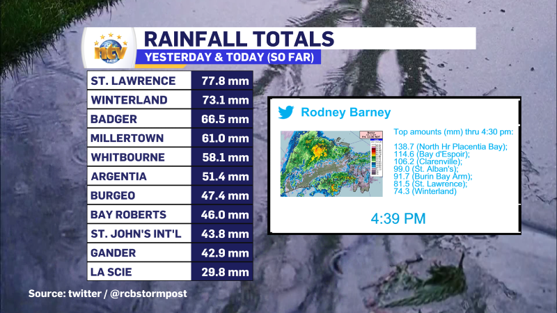
Multiple areas see 100+ mm of rain in southeastern Newfoundland
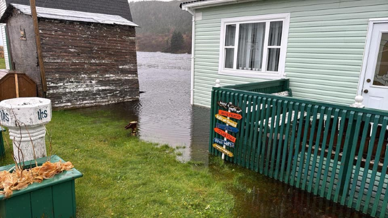
The above image was shared to me by April Wells, and was taken in Mose…
-
The rain ends overnight, setting us up for a calmer weekend
Get all the details in my forecast from Friday’s NTV Evening Newshour!
-

Heavy rain falling over much of the Island this morning
This is my forecast from last night’s NTV Evening News Hour. Even though it is…
