


The coldest air of the winter is set to invade the Province over the coming days. It will first arrive in Labrador West later today and tonight and then spread across the rest of Newfoundland and Labrador Tuesday into Wednesday. The Environment and Climate Change Canada Weather Office in Gander has already issued an Extreme Cold Warning for Labrador City and Wabush, and Churchill Falls and vicinity from tonight through Wednesday. Wind chills are not expected to budge much above -45ºC thanks to northwest winds gusting as high as 60 km/h.

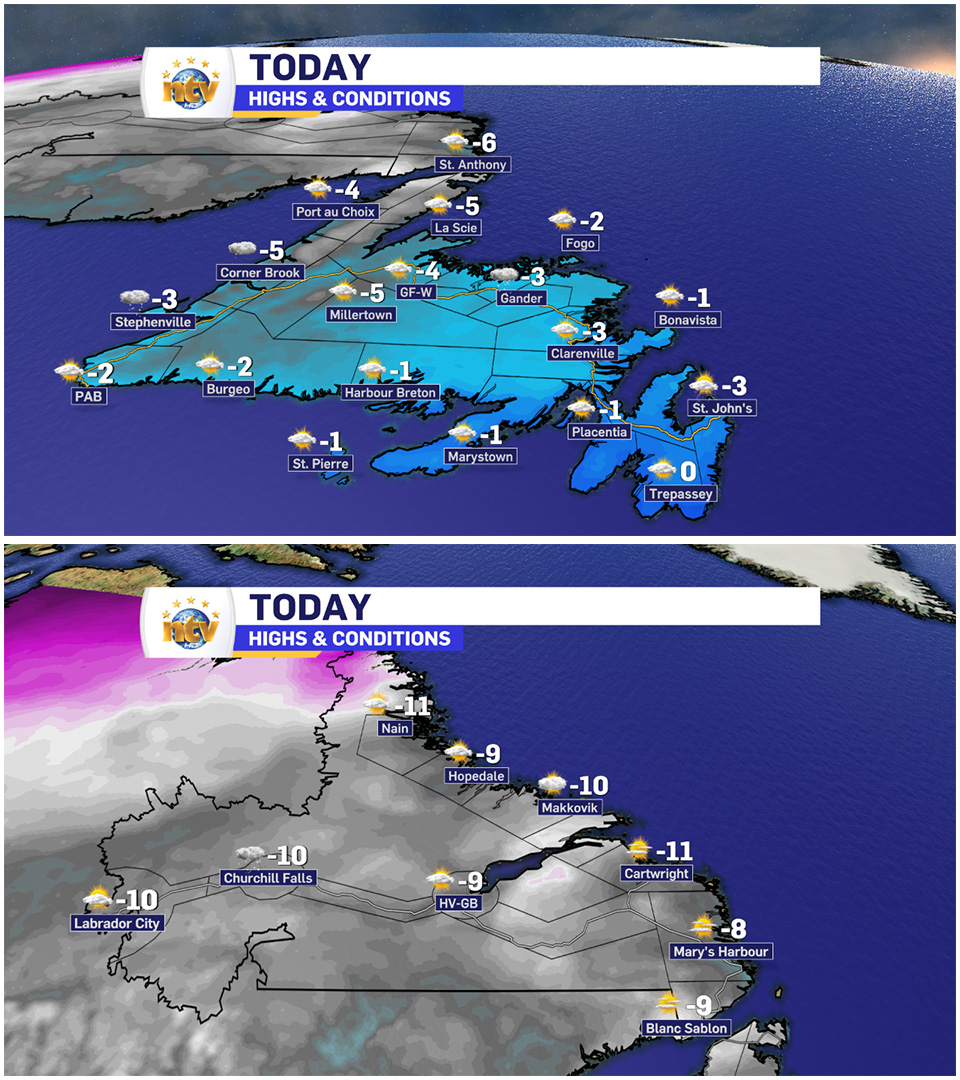
Out ahead of the Arctic Air, on our Monday, the weather across N.L. will be generally quiet under a mix of sun and cloud. We will see some flurries developing later today over the western part of Labrador and then, eventually, around this evening, near the West Coast of Newfoundland. Highs will be seasonable for the time of year ahead of the Arctic Air.
The cold air will really move overnight (Labrador) and will spread across the rest of NL between later Tuesday and Wednesday. The animation below should show you how that plays out quite nicely.
With the cold air will come some flurries and pockets of light snow across much of the Province between Monday night (Labrador) and Tuesday into Wednesday (on the Island). Currently, it doesn’t look like there will be widespread heavy snowfall, but parts of the West Coast will see some intense flurries during the time frame, and locally significant snow accumulations will occur.
The remainder of the week looks milder, with no significant weather makers in play. Parts of eastern Newofundlnad may see snow Friday into Saturday, but that’s a big might right now.
I’ll have your full forecast on NTV this evening and shortly after on this website. Have a great day!
Eddie
-

Labrador West MHA wants water bomber back
With wildfires threatening Fort McMurray, Alta., again, Labrador West MHA Jordan Brown wants a water…
-

Province warns residents to be ready for forest fire season as wildfires threaten Fort McMurray
Evacuation orders and alerts remain in effect for Fort McMurray, Alta., as wildfires continue to…
-
Your Latest Forecast!
Click here to visit the NTV Weather Centre to get your latest forecast!
