


Incoming storm brings rain, snow and wind through Tuesday and Wednsday

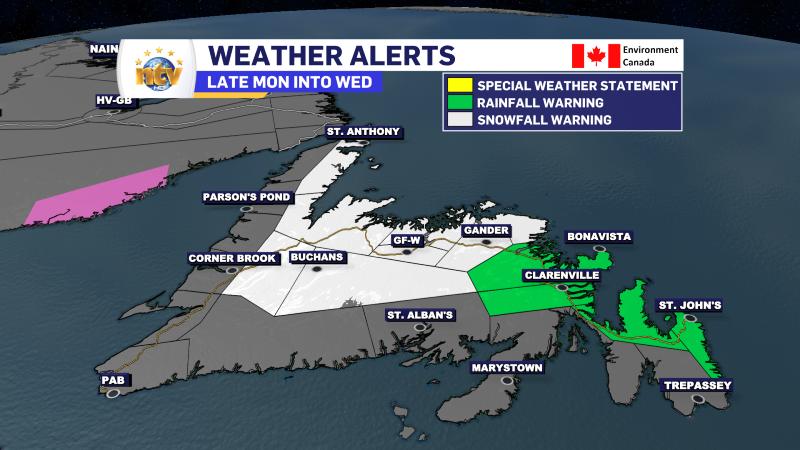
ECCC NL has multiple weather alerts related to this system. Rainfall, Snowfall, and Wind Warnings are all in effect for various areas of the Island. You can read about them here.

TUESDAY’S FORECAST
The Avalon and Burin Peninsula will see the rain end in the morning. Beyond that, these areas are looking at cloudy skies, areas of fog, and drizzle in the light onshore flow. The fog may be very dense in some areas in the morning. There is a chance parts of the South Coast, Burin, and Avalon Peninsulas break into some sunshine during the second half of the afternoon.
To the west, as far west as the eastern side of the Great Northern Peninsula, expect periods of rain and snow to continue throughout the day. Areas inland will likely see snow, while areas near the coast will see either a mix of wet snow and rain or just plain rain. The Bonavista Penisula will see rain in the lower elevations and wet snow in the higher terrain. Travel in some areas of the Bonavista Peninsula Highway will be very wintry.
Snowfall amounts for northeastern areas, including Gander and through much of Central, will be less, but an additional 5 to 10 cm is likely. The higher elevated areas of Green Bay – White Bay and the eastern slopes of the Long Range Mountains on the GNP will see another 15 to 30 cm on Tuesday.

Areas of the West Coast will see rain showers or wet snow flurries. The Southwest Coast will see dry conditions and cloudy to mostly cloudy skies.
The wind will be much less of an issue for most on Tuesday. However, the Northern Peninsula may see some high gusts to 60 or 70 km/h, resulting in locally stormy conditions in the snow.
Temperatures across the board will be near the freezing mark. Perhaps a bit above the south and east.
WEDNESDAY’S FORECAST
A final wave of low pressure will pack in from the Atlantic, bringing one more wave of rain and snow to central and eastern Newfoundland. At this point, it’s a bit challenging to identify snowfall amounts from this last wave, but a few centimeters is likely to fall from the Avalon Peninsula to the eastern side of the northern Peninsula. The Burin Peninsula and Connagire will likely see a mix of snow and rain.
The temperatures remain mild, and the wind will kick up from the north during the day as this final wave moves in. Wind Warnings may be required along portions of the northeast coast where gusts of 100 km/h will be likely.
THURSDAY/FRIDAY FORECAST
Calmer across the region with no notable weather.
LABRADOR’S FORECAST
The weather in the Big Land looks very quiet over the coming 5 days, and there will be no impactful weather on the horizon this week. The one thing Labradorinas will notice is the unseasonable warmth. Temperatures will run well above average all week. Highs during the day will be a few degrees below freezing and lows overnight will be in the minus teens. Expect various amounts of sunshine and occasional flurries.