Post 3 – 6:41 PM NST (6:11 PM AST)
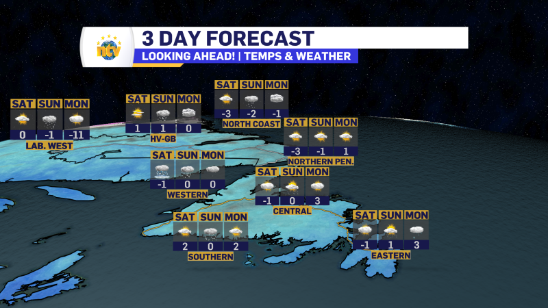
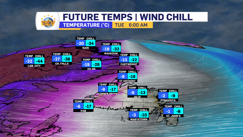
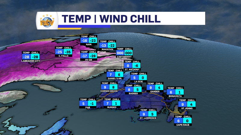
The Arctic has arrived over western Newfoundland and will continue its push across the Island overnight. Labrador’s temperatures have already drifted toward the -20s and will freefall into the -30s overnight. While the Island will not get that cold by Tuesday morning, it will be sharply colder than today.
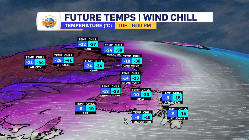
Here is a look at the forecast temperatures for tomorrow morning and again tomorrow evening. Temperatures will not do much moving tomorrow… in fact, for most areas, that will actually fall throughout the day.
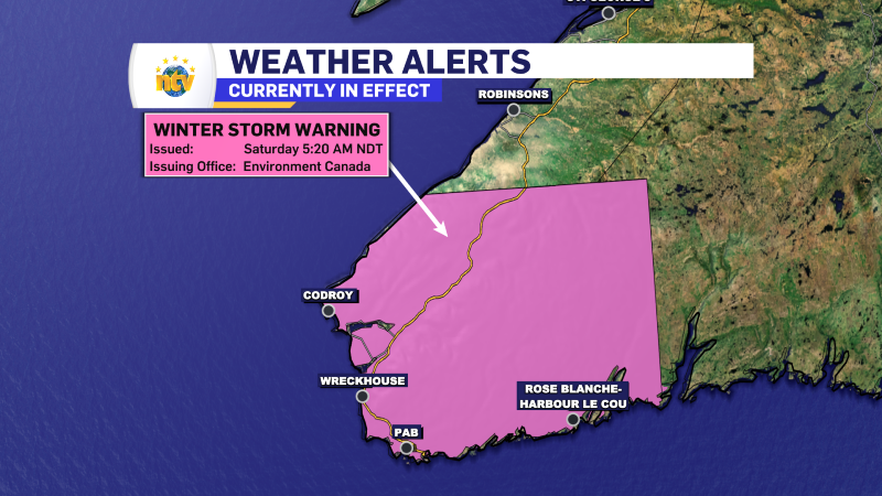
As of this post, several weather alerts were in effect for the Province. By tomorrow morning, the Snowfall, Winter Storm, and Wind Warnings will have ended in southeast Labrador and coastal Newfoundland, but the Extreme Cold Warning and the Snow Squall Watch will remain.
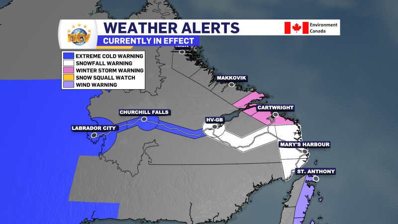
Areas under the Extreme Cold Warning will see wind chills of -50 to -45 early Tuesday morning and again early Wednesday morning.
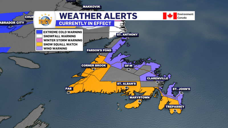
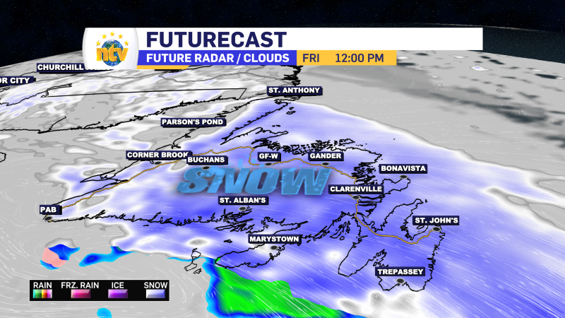
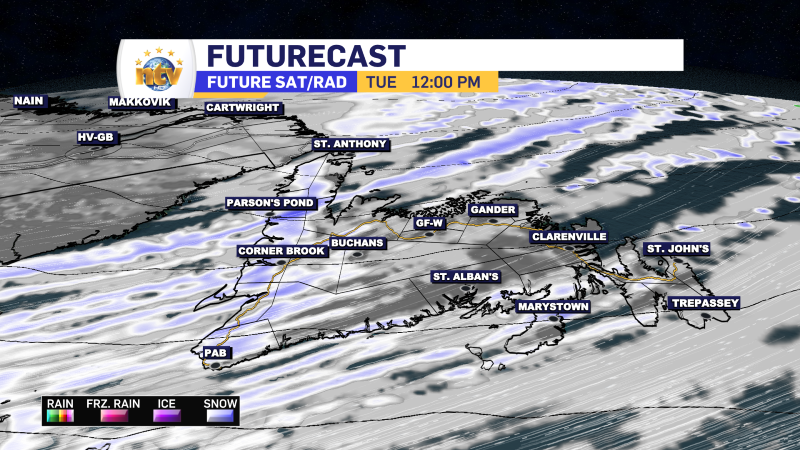
Areas under the Snow Squall Watch will see snow squalls develop overnight and continue through Tuesday. The squalls will be the most intense and numerous along the West Coast, where locally significant amounts will be found. There will be snow squalls along the South Coast, Burn, and Avalon Peninsulas, too, but they will not be as widespread. I think there is a good chance the watch gets expanded to Avalon North and St. John’s tomorrow as squalls look like they will drift north. Remember, a Snow Squall Watch means conditions are favorable for developing snow squalls. A Warning means they are happening.
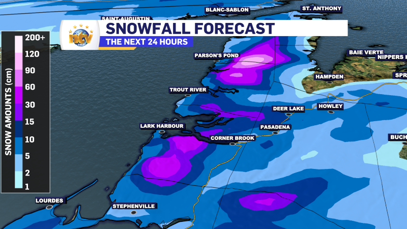
Snowfall amounts are more challenging to forecast from the squalls because small-scale features are tricky to pinpoint in computer guidance. That being said, the high country of western Newfoundland will see heavy snowfall over the next 24 hours… and beyond. By the end of the week, some the hills will have seen close to a meter of new snow.
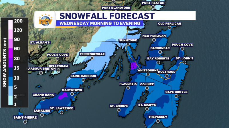
Outside of the squalls, the weather tomorrow doesn’t look too bad… but it will be breezy and cold (as you can see above). Wednesday seems interesting for the Avalon as the first widespread snowfall of the year may be in the cards. There is a bit of uncertainty, but as of now, my confidence is medium that a widespread 5 to 10 cm is on the way. Locally higher amounts are possible. And some areas will see more than that in squalls over the next 24 hours.
Post 2 – 12:39 PM NST (12:09 PM AST)
Temperatures across the Province vary widely this afternoon. We are seeing well above normal temperatures on the Island, while the coldest air of the year is pressing southward from Labrador.
Many areas of Labrador are reporting snowfall right now; however, along the Straits, it’s likely a mix. And as of this hour, St. Anthony Airport is reporting freezing rain. This means the stationary boundary associated with the low is a tad farther east than forecast. As the afternoon progresses, that may not change much, and freezing rain may fall for several hours before the change to snow this evening.
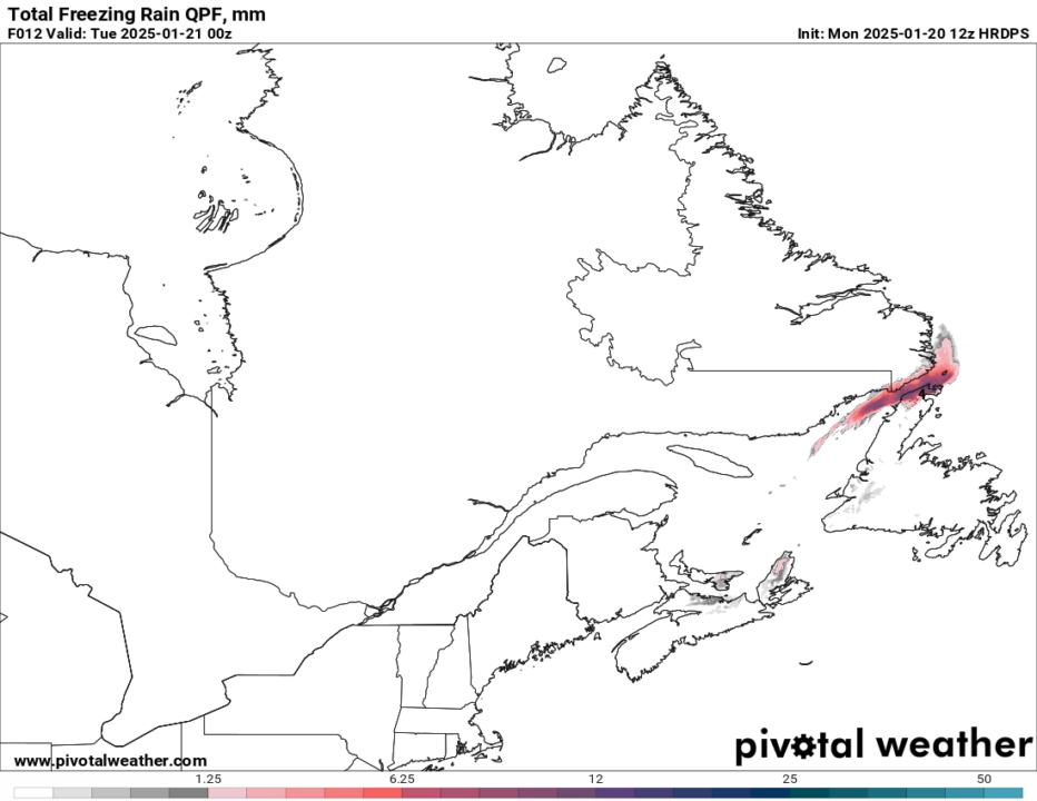
Forecasts indicate that 5 to 10 mm of freezing rain is quite likely this afternoon, especially on the northern part of the Peninsula. This may require alerts from ECCC NL and could lead to localized power disruptions.
Post 1 – 6:07 AM NST (5:37 AM AST)
Good Monday morning!
A potent area of low pressure will bring a mixed bag of weather to the Province today, followed by a sharp cool down later today or tonight as the first bout of true arctic air of the winter moves in. The highlights of this weather-maker will be rain and wind over the Island today while heavy snow falls over the southeast quadrant of Labrador. The snow will mix rain ice pellets and freezing rain along the Labrador side of the Strait of Belle Isle.
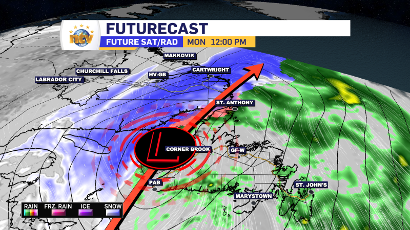
The low will depart overnight and behind it the coldest air of the season will be ushered into the region. The incoming cold air will drive intense snow squalls that will first be seen on the West Coast of the Island early Tuesday but will quickly spread to the South Coast, Burin, and Avalon Peninsula during the day. The snow in these snow squalls will be locally intense, and travel across many of the areas mentioned will be locally challenging.
The Forecast
Monday’s Weather
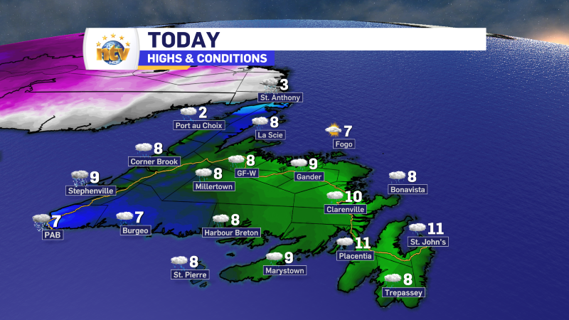
Periods of rain over the Island with unseasonably warm temperatures. The rain will be heaviest this morning and will taper to showers this afternoon. There may even be some sunny breaks over eastern areas this afternoon! It will be breezy all day, but wind speeds will peak over the eastern half of the Island, with gusts of 80 to 100 km/h.
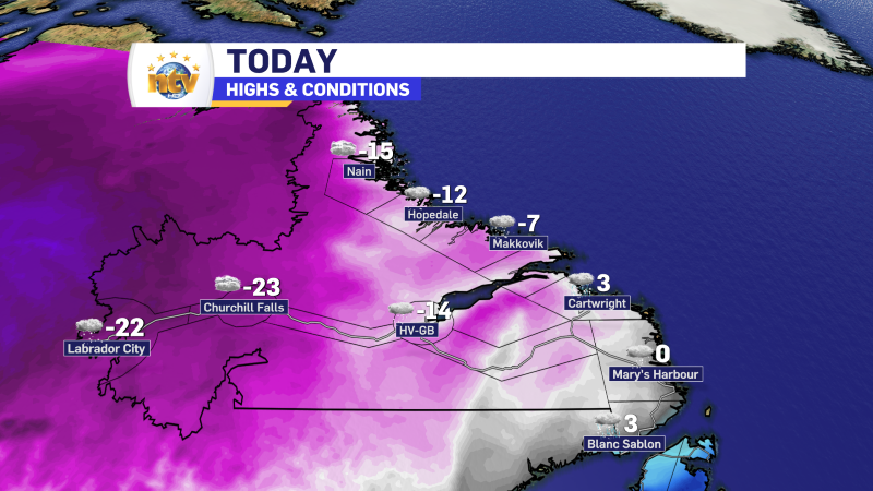
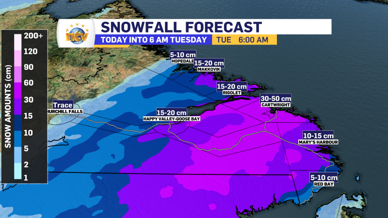
Snow will fly along the Labrador Coast through the day, and about as far west as the Churchill Valley. The heaviest will be near Cartwright, which is expected to be near 30 cm. Locally higher amounts are possible. Winter Storm conditions will also be found along parts of the coast as the wind ramps up this evening as the area of low pressure strengthens and departs.
WEATHER ALERTS
Here is a table of weather alerts I will try to keep updated throughout the day. Be sure to check the ECCC Weather Alert Site for up to the minute alerts if you’re looking for those.
Wind Warning (Gusts of 80 to 100 km/h this evening)
- Avalon Peninsula North
- Bay of Exploits
- Bonavista North
- Bonavista Peninsula
- Green Bay – White Bay
- Northern Peninsula East
- St. John’s & vicinity
- Terra Nova
Winter Storm Warning
- Cartwright to Black Tickle
- Rigolet and vicinity
Snowfall Warning
- Eagle River
- Upper Lake Melville
- Red Bay to L’anse-au-Clair
Blowing Snow Advisory
- Postville – Makkovik
Snow Squall Watch (Tuesday)
- Avalon Peninsula Southeast
- Avalon Peninsula Southwest
- Bay St. George
- Burge – Ramea
- Burin Peninsula
- Channel-Port aux Basques & vicinity
- Connaigre
- Corner Brook & vicinity
- Deer Lake – Humber Valley
- Gros Morne
Extreme Cold Warning
- Labrador City and Wabush
- Churchill Falls and vicinity
- The Churchill Valley
.png)


.png)
