


Major winter storm to hit Eastern Newfoundland

It’s the calm before the storm. According to NTV’s Ryan Harding, anywhere from 30 to 45 centimeters of snow expected in the metro area Tuesday and Wednesday, with wind gusts in excess of 80 km/h.
The storm is expected to last into the early hours Thursday. Periods of snow, freezing drizzle or drizzle will continue into the weekend.
Impacted regions include areas in and around St. John’s, the Avalon Peninsula, Terra Nova and the Bonavista Peninsula.
“Locations inland and over higher terrain have the best chance of seeing the upper end of the forecast range, while the lower end of the range is more likely at lower elevations along the coast,” Environment Canada notes. “While the heaviest snow is expected to taper off Wednesday night, periods of snow, freezing drizzle or drizzle will continue into the weekend, resulting in additional snowfall accumulations.”
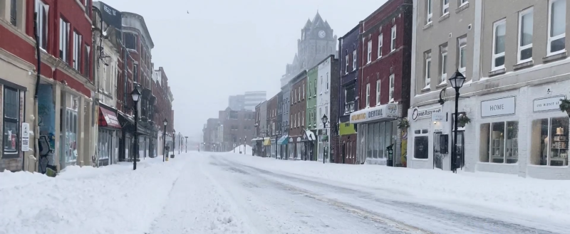
Cancellations are already starting. Numerous schools are expected to be closed Wednesday. Some medical appointments have been rescheduled and travel advisories remain in place, on ground and in the air.
ST. JOHN’S/BONAVISTA
Today: Mainly cloudy. 40 percent chance of flurries this morning with risk of freezing drizzle. Fog patches dissipating this morning. Wind becoming north 20 km/h this morning then becoming northeast 20 gusting to 40 this afternoon. High plus 2. Wind chill minus 8 this morning. UV index 1 or low.
Tonight: Cloudy. Snow at times heavy beginning late this evening. Blowing snow overnight. Amount 15 to 25 cm. Wind northeast 30 km/h gusting to 50 becoming north 40 gusting to 70 overnight. Low minus 1. Wind chill minus 10 overnight.
Wednesday: Snow at times heavy and blowing snow. Amount 10 to 20 cm. Wind north 50 km/h gusting to 80. Temperature steady near zero.
SOUTH COAST
Today: A mix of sun and cloud. Wind becoming northeast 20 km/h gusting to 40 this morning. Temperature steady near zero. UV index 1 or low.
Tonight: Partly cloudy. Wind northeast 20 km/h gusting to 40 becoming north 30 gusting to 50 near midnight. Low minus 3. Wind chill near minus 10.
Wednesday: Mainly sunny. Wind north 30 km/h gusting to 50 becoming northwest 20 gusting to 40 in the afternoon. High plus 1. Wind chill minus 10 in the morning. UV index 1 or low.
CENTRAL
Today: Cloudy with 40 percent chance of flurries and risk of freezing drizzle. Fog patches dissipating this morning. Wind becoming northeast 20 km/h this afternoon. High minus 1. Wind chill minus 3 this morning and minus 8 this afternoon. UV index 1 or low.
Tonight: Mainly cloudy. 40 percent chance of flurries early this evening with risk of freezing drizzle. Wind northeast 20 km/h gusting to 40 becoming north 30 gusting to 50 overnight. Low minus 3. Wind chill near minus 9.
Wednesday: Cloudy. Snow beginning early in the morning. Blowing snow over exposed areas. Amount 5 to 10 cm. Wind north 30 km/h gusting to 60. High minus 1. Wind chill near minus 9.
WEST COAST
Today: A mix of sun and cloud. Wind up to 15 km/h. High minus 1. Wind chill near minus 9. UV index 1 or low.
Tonight: Mainly cloudy. Wind northeast 20 km/h. Low minus 7. Wind chill minus 9 this evening and minus 14 overnight.
Wednesday: A mix of sun and cloud. Becoming cloudy late in the afternoon. Wind northeast 20 km/h becoming north 20 gusting to 40 in the afternoon. High minus 1. Wind chill minus 12 in the morning and minus 7 in the afternoon. UV index 1 or low.
NORTHERN PENINSULA
Today: Mainly cloudy. 60 percent chance of flurries this morning with risk of freezing drizzle. Fog patches dissipating this morning. Wind up to 15 km/h. High minus 3. Wind chill near minus 8. UV index 1 or low.
Tonight: Mainly cloudy. Wind becoming northeast 20 km/h gusting to 40 overnight. Low minus 5. Wind chill near minus 10.
Wednesday: Mainly cloudy. 40 percent chance of flurries late in the afternoon. Wind northeast 20 km/h gusting to 40 becoming north 30 gusting to 50 in the morning. High minus 1. Wind chill near minus 10. UV index 1 or low.
HAPPY VALLEY/GOOSE BAY
Today: Cloudy with 40 percent chance of flurries this morning then a mix of sun and cloud. Wind up to 15 km/h. High zero. Wind chill minus 15 this morning. UV index 1 or low.
Tonight: Cloudy. 60 percent chance of flurries overnight. Wind up to 15 km/h. Low minus 7. Wind chill near minus 12.
Wednesday: Mainly cloudy. 40 percent chance of flurries in the morning. Wind up to 15 km/h. High minus 4. Wind chill near minus 12. UV index 1 or low.
Ryan Harding will have the latest in First Edition at 5:30 and the NTV Evening Newshour at 6.