Forecast Discussion
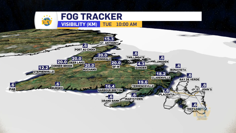
A cold front is located over Labrador which is separating warmer air over the Island from cooler air over most of Labrador. This cold front will swing out of Labrador and across the Island over the next 24 hours or so. This will not bring a big drop in temperatures, but it will bring some rain and rain showers to western and southern Newfoundland tonight and central and eastern areas late tonight into Tuesday morning. Any showers will be done, over the eastern sections of the Island, by lunchtime Tuesday. Scattered flurries will be found over Labrador throughout the day.
The next low-pressure centre will approach the Island Tuesday night. This will be north of the Baie Verte Peninsula by Wednesday morning. Areas of Central and Western Newfoundland, along with southern Labrador will see rain and snow from this. The snow looks to be limited to the top of the Great Northern Peninsula and southern Labrador. Amounts do not look to be heavy at this time.

A third low will pass over eastern Newfoundland Wednesday night. This will bring heavy rainfall to the eastern third of the Island Wednesday afternoon into early Thursday morning. Behind this, we are in for a chilly, but sunny day Thursday.

MAY 2-4 Preview
As it looks now, there is a good chance Saturday and Sunday are dry, sunny and warm across much of the Island for the long weekend. In fact, mah areas may see the first chance of seeing 20°, or more, Sunday over Central and eastern sections of the Island and possibly southern Labrador. There looks to be a chance of rain by Monday for much of the Province… although the weather over the weekend in Labrador may be a bit more unsettled. Stay tuned for updates on this one!

Newfoundland Short-Range Forecast
Tonight: Risk of showers across the board, with rain likely early over the West Coast and southwest coast. Lows of 4 to 7. Winds west or southwest at 20-40 km/h
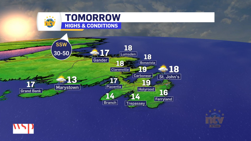
Tuesday: Chance of showers over eastern sections in the morning, otherwise becoming mostly sunny across the board. Highs in the lower to mid-teens, except closer to 8 in onshore westerlies. Winds from the west or southwest at 15-30 km/h.
Wednesday: Rain and snow in the morning over the GNP will end. Rain arrives thru the South Coast, Central, and East Coast during the afternoon. Rain becomes heavy at times over Eastern in the evening. Highs in the mid-teens for the eastern half of the Island and closer to 10 for the western half.
Labrador Short-Range Forecast
Tonight: Scattered snow showers. Lows of -1 east to -6 in the west and north.
Tuesday: Mostly cloudy to cloudy with scattered snow and rain showers. Highs of 3 to 6.
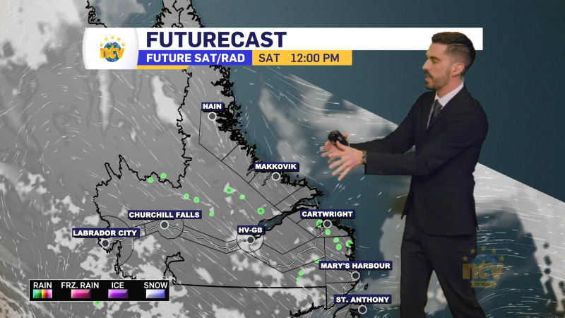
Wednesday: Snow near the Straits, otherwise cloudy to mostly cloudy with scattered flurries. Highs of 2 to 4.
Have a good one!
/Eddie