
An area of low pressure will pass into northern Quebec between Tuesday and Wednesday. South of this low, a warm will lift across the Province between Tuesday and Wednesday. The front will drive some messy weather throughout much of Labrador on Tuesday, followed by rain on the Island Tuesday night and Wednesday. The weather from this doesn’t look to be overly significant, but some areas will see some snow (Labrador), and some will see some rain (Newfoundland).
We get warm on the Island Wednesday south of the warm front, followed by a cool-down Thursday as the cooler air returns. There are some signals of West Coast flurries later this week, but the air aloft doesn’t look overly cold, so the intensity should be muted somewhat.
Your extended forecast is below.
TONIGHT
- Scattered flurries on the Island, otherwise partly cloudy to mostly clear.
- Lows of 0 to -4
- Mostly clear on the coast of the Big Land, while clouds lower and thicken in the west.
- Chance of light snow near Labrador City and Wabush after 3 or 4 AM.
- Lows of -2 to -6
TUESDAY
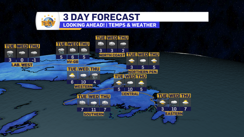
- Clouds increase for eastern and central Newfoundland and much of the South Coast to the east of Ramea.
- The West Coast, Southwest Coast and much of the Northern Peninsula will have rain showers arriving during the afternoon.
- Highs of 3 to 7
- Precipitation moves into much of Labrador throughout the day. Areas around Labrador City and Wabush will have snow in the morning, quickly changing to rain. A bit farther east, in Churchill Falls and through much of the Churchill Valley, snow will fall through much of the day before ending as drizzle Tuesday evening.
- Snowfall 5 to 10 cm
- Highs near 3
- The coast, north of let’s say Port Hope Simpson, will see snow by afternoon or evening Tuesday, which will end as drizzle Tuesday evening or night.
- Snowfall 2 to 5 cm
- Highs of 1 to 3, except 5 near Goose Bay
WEDNESDAY
- Periods of rain across the Island.
- Highs near 10
- Scattered flurries and showers in most of Labrador.
- Highs of 0 to 5
THURSDAY
- Scattered showers and flurries, with areas of more intense flurries near the West Coast
- Cooler with highs of 4 to 6
- Scattered flurries throughout the region
- Highs of -1 to 4
FRIDAY
- Chance of rain or snow along and near the west coast in the afternoon
- HIghs of 3
- Scattered flurries in Labrador West
- Highs of -1
SATURDAY
- Chance of rain and snow across the Island
- Highs near 3
- Scattered flurries along and near the coast of Labrador
- Highs near -1


