Weather Forecast: Sunday, June 7

Rain is expected to spread across much of Newfoundland today, with some areas forecast to receive more than 20 millimetres before conditions begin improving Monday. Here’s your weather forecast.
St. John’s / Bonavista
Today
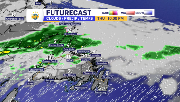
Cloudy skies dominate across eastern Newfoundland. A few showers may develop late this afternoon in Bonavista, while St. John’s remains mainly cloudy. Winds from the southeast gust up to 40 km/h. High 10 in St. John’s and 13 in Bonavista, though coastal areas remain cooler. UV index 5 to 7, moderate to high.
Tonight
Rain develops across the region overnight. Fog patches form this evening, reducing visibility at times. Rainfall amounts of 5 mm are expected in St. John’s, with 10 to 20 mm possible in Bonavista. Lows near 5 to 7.
Mon, June 8
Rain continues through the morning before tapering off later in the day. Temperatures fall sharply behind the system, settling near 5 in Bonavista and dropping from 11 to 5 during the day in St. John’s. Fog gradually lifts. UV index low to moderate.
South Coast
Today
Rain, at times heavy, affects Channel-Port aux Basques. Fog patches persist and visibility may be reduced. Rainfall amounts of 15 to 25 mm are expected. Southeast winds gust as high as 60 km/h, with gusts reaching 100 km/h in the Wreckhouse area early this afternoon. High 8, except 12 north of Cape Ray.
Tonight
Rain gradually ends overnight, leaving cloudy skies. Winds shift north and strengthen to 30 km/h gusting to 50. Low 6.
Mon, June 8
Skies clear through the morning. North winds continue, but sunshine returns. High 12. UV index 7 or high.
Central
Today
Cloudy conditions continue in Gander, with rain arriving this afternoon. Rainfall amounts of 2 to 4 mm are expected during the day. Southeast winds gust to 40 km/h. High 12. UV index 5 or moderate.
Tonight
Steadier rain develops, with 15 to 25 mm expected. Fog patches may reduce visibility. Low plus 4.
Mon, June 8
Rain continues before mixing with wet snow late in the morning and early afternoon as temperatures briefly fall to around 2 degrees. Northwest winds increase to 30 km/h gusting to 50. Conditions improve later in the day. UV index 1 or low.
West Coast
Today
Periods of heavy rain continue in Corner Brook, with 20 to 30 mm expected. High 9. UV index 2 or low.
Tonight
Rain ends near midnight, leaving cloudy skies. An additional 5 mm of rain is possible before precipitation tapers off. Low plus 4.
Mon, June 8
Cloudy skies gradually give way to clearing conditions during the afternoon. Northeast winds gust to 40 km/h. High 13. UV index 4 or moderate.
Northern Peninsula
Today
Rain and fog persist across the region, with rainfall amounts of 15 to 25 mm expected in St. Anthony. Temperatures remain steady near 7. UV index 1 or low.
Tonight
Rain ends near midnight, followed by cloudy skies and a chance of rain showers or flurries. Northeast winds gust to 50 km/h. Low plus 2.
Mon, June 8
Mainly cloudy with a chance of morning flurries or rain showers before precipitation becomes all rain showers. Winds from the north gust to 50 km/h. High 8. UV index 5 or moderate.
Happy Valley–Goose Bay
Today
Mainly cloudy with a 60 per cent chance of showers. Northeast winds increase to 20 km/h gusting to 40 this afternoon. High 15. UV index 5 or moderate.
Tonight
Skies clear this evening as winds ease overnight. Low plus 3.
Mon, June 8
Sunny and much warmer. High 22. UV index 6 or high.
Related Articles