


Heavy snow expected for province’s west coast; mild conditions in Eastern Newfoundland
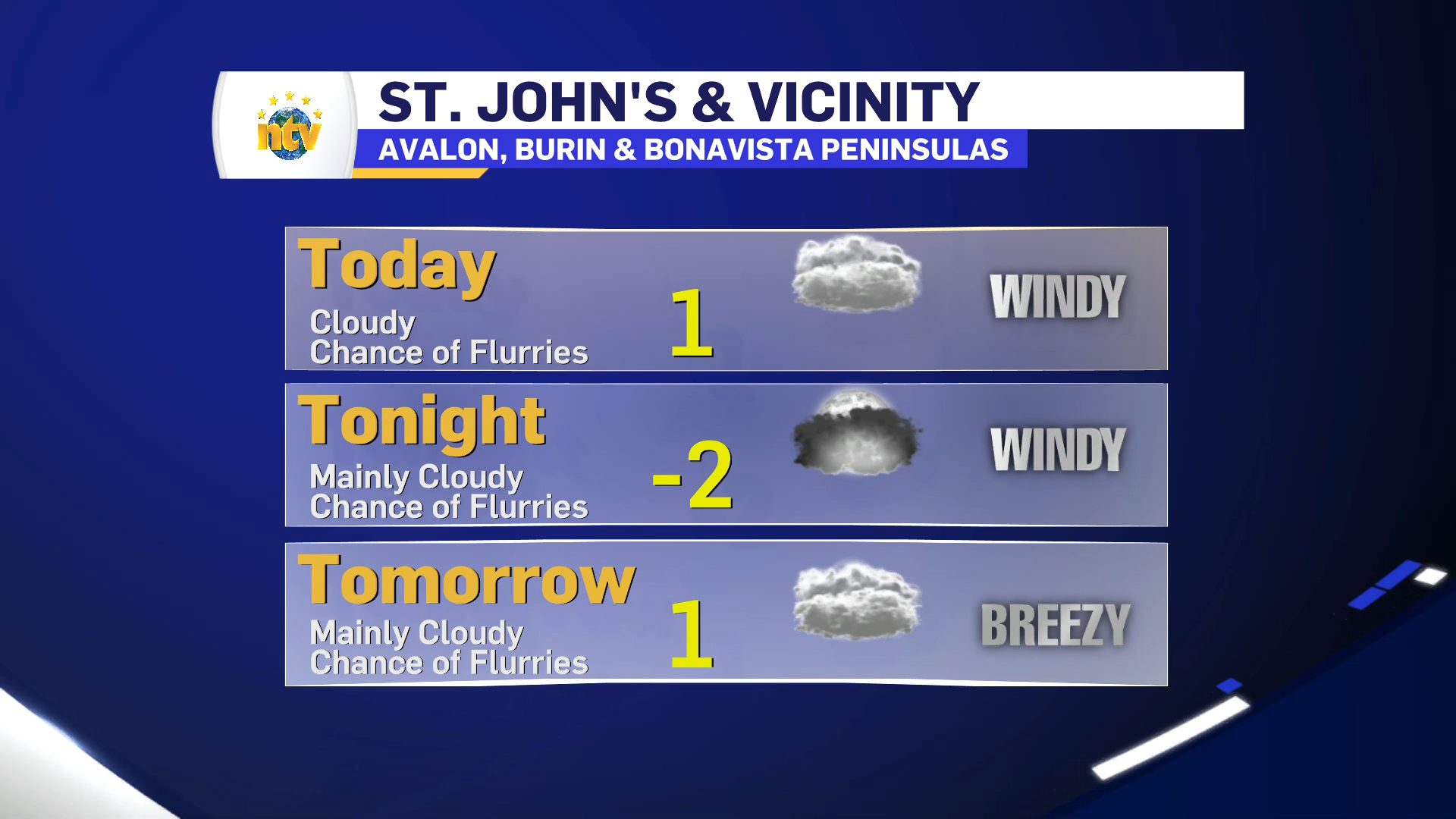
ST. JOHN’S/BONAVISTA
Today: A few flurries ending this morning then cloudy with 40 percent chance of flurries. Wind southwest 40 km/h gusting to 60. Temperature steady near plus 1. UV index 1 or low.
Tonight: Mainly cloudy with 40 percent chance of flurries. Wind southwest 40 km/h gusting to 60 becoming west 30 gusting to 50 overnight. Low minus 2. Wind chill near minus 10.
Sat, 14 Feb Mainly cloudy with 40 percent chance of flurries. Wind west 20 km/h gusting to 40. High plus 1. Wind chill minus 8 in the morning. UV index 1 or low.
SOUTH COAST
Today Mainly cloudy. 40 percent chance of flurries this morning. Wind west 20 km/h gusting to 40 increasing to 40 gusting to 60 this morning. Temperature steady near zero. UV index 1 or low.
Tonight: Cloudy. A few flurries over the higher terrain along the Burgeo Highway overnight. Local amount 2 cm over the higher terrain along the Burgeo Highway. Wind west 30 km/h gusting to 50. Low minus 2. Wind chill near minus 9.
Saturday: Cloudy. A few flurries over the higher terrain along the Burgeo Highway. Local amount 2 cm over the higher terrain along the Burgeo Highway. Wind west 20 km/h. Temperature steady near minus 1. Wind chill near minus 8. UV index 1 or low.
CENTRAL
Today: Mainly cloudy. 40 percent chance of flurries changing to 40 percent chance of rain showers or flurries near noon. Wind becoming west 30 km/h gusting to 50 this morning. High plus 2. Wind chill minus 7 this morning. UV index 1 or low.
Tonight: Mainly cloudy with 40 percent chance of flurries. Wind west 30 km/h gusting to 50 becoming northwest 20 overnight. Low minus 1. Wind chill near minus 8.
Saturday: Flurries. Wind northwest 20 km/h becoming light near noon. High plus 1. Wind chill minus 7 in the morning. UV index 1 or low.
WEST COAST
Today: Snow except snow at times heavy over higher terrain. Amount 5 cm except 15 cm over higher terrain. Wind becoming west 30 km/h gusting to 50 this morning. Temperature steady near zero.
Tonight: Periods of snow. Amount 2 to 4 cm. Wind west 20 km/h gusting to 40 becoming light near midnight. Low minus 3. Wind chill minus 8 overnight.
Saturday: Flurries. Amount 2 cm. Wind up to 15 km/h. High zero. Wind chill minus 8 in the morning.
NORTHERN PENINSULA
Today: Snow changing to rain showers or flurries near noon. Snowfall amount 2 cm. Wind north 20 km/h gusting to 40 becoming northwest 30 gusting to 50 near noon. High plus 1.
Tonight: Rain showers or flurries ending after midnight then mainly cloudy. Wind northwest 40 km/h gusting to 60 diminishing to 20 gusting to 40 near midnight. Temperature steady near zero.
Saturday: Mainly cloudy. Wind northwest 20 km/h. Temperature steady near zero. Wind chill minus 7 in the morning. UV index 1 or low.
HAPPY VALLEY/GOOSE BAY
Today: Periods of snow mixed with rain. Snowfall amount 2 cm except locally 10 cm over higher terrain. Wind north 20 km/h gusting to 40. High plus 1.
Tonight: Periods of snow ending early this evening then cloudy with 40 percent chance of flurries. Wind north 20 km/h gusting to 40. Low minus 3. Wind chill minus 9 overnight.
Saturday: Cloudy with 40 percent chance of flurries. Wind northwest 20 km/h gusting to 40 becoming north 20 near noon. Temperature steady near minus 2. Wind chill near minus 9. UV index 1 or low.