


NTV Weather Update | February 25, 2025
Post 2 – 6:45 PM NST (6:15 PM AST)
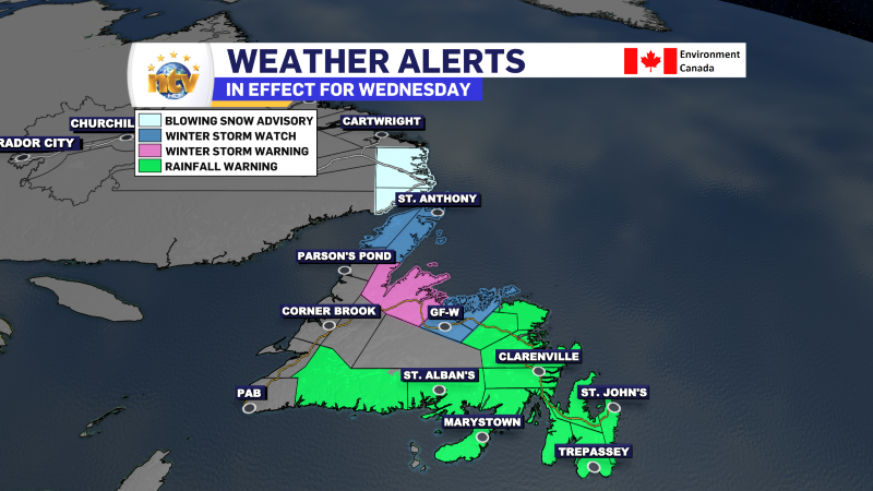
Rainfall and Winter Storm Warnings, along with a Winter Storm Watch and a Blowing Snow Advisory, are in effect for various areas of the Province from Wednesday morning through late evening or early Thursday.
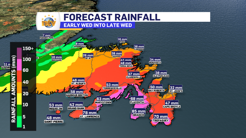
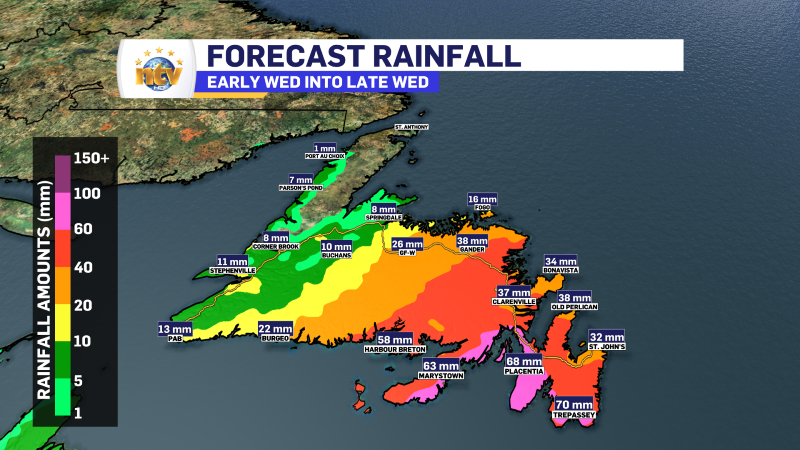
Rainfall will be heaviest in the south and east, exceeding 50 mm for many locations. Areas farther north, still under the rainfall warning, will see lower amounts of rain. However, with temperatures being so warm and upwards of 30 mm of rain in the forecast for Wednesday, rapidly melting snow and localized flooding are a concern.
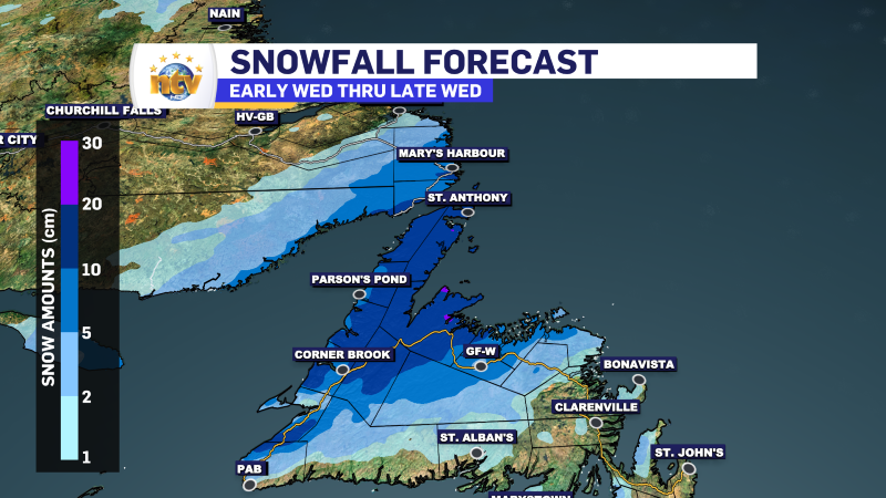
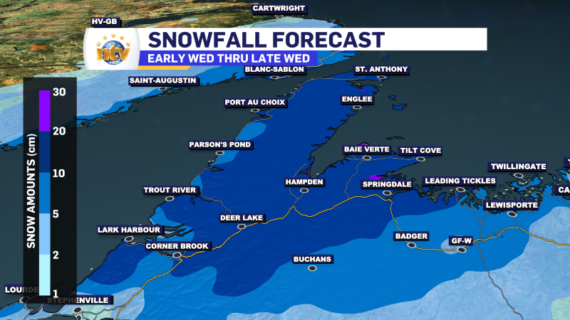
The snowfall forecast is a bit more trick, but overall, 10-20 cm is in the forecast for parts of central, western, and northwestern Newfoundland. Amounts may be locally higher.
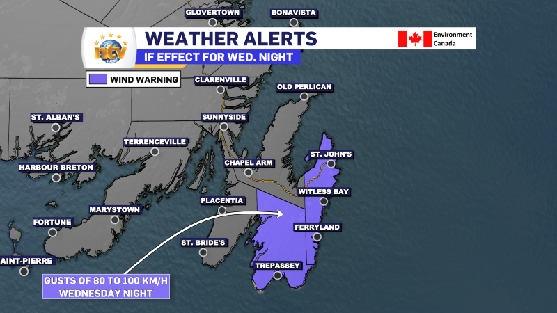
A Wind Warning is also in effect for St. John’s and the Southern Shore, along with the Avalon Peninsula Southeast for Wednesday night, for gusts as high as 100 km/h.
Post 1 – 5:49 AM NST (5:19 AM AST)
A weak disturbance will traverse the Province today. This will bring some light snow and flurries to Labrador, the West Coast, parts of the Southwest Coast, and interior Newfoundland. Outside of the mountains in western Newfoundland, less than 5 cm will fall in the areas that see snow today. The snow will end late this afternoon for the Island and a bit earlier in much of the Big Land.
Southern, central and eastern sections of the Island will see light snow mixed with rain or just light rain showers this afternoon, ending this evening.
Today’s highs for the island and southeast Labrador will be near or a few degrees above freezing. At the same time, a cold front will charge through northern and western Labrador, knocking temperatures back to the minus teens and 20s this afternoon and evening.
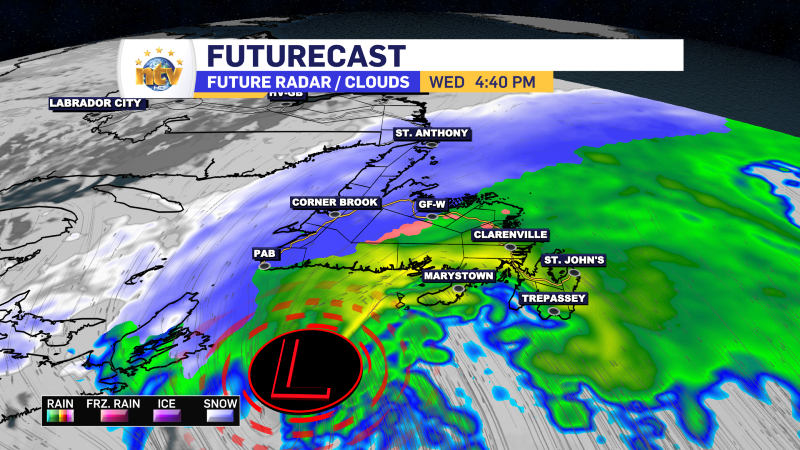
This system moving through is just the appetizer for Wednesday’s weather, which will bring another winter storm to the region. This will bring heavy rain to eastern Newfoundland, heavy snow to western and southeast Labrador, and a mix of rain and snow through Central. Weather alerts are in effect ahead of this weather-maker.

The highlights from his system are as follows:
- Rain and snow spread across the Island late Tuesday night or early Wednesday morning
- By Wednesday morning, rain or rain mixed with wet snow will be falling over much of the Island except the Great Northern Peninsula, where it will snow.
- Snow also arrives in southeast Labrador on Wednesday morning
- Rain will transition to heavy snow Wednesday afternoon over and near the West Coast
- The rain/snow line will move eastward into Central by Wednesday evening, also changing the rain over to heavy snow
- The snow ends for most areas Wednesday evening, including in the Straits of Labrador.
- Areas along and east of the Bay d’Espoir Highway look to remain mostly rain, only ending as some snow late Wednesday.
- The rain will fall heavily in this area on Wednesday afternoon and evening.
- Rainfall rates of 10 mm/hr are possible
- The rain will fall heavily in this area on Wednesday afternoon and evening.
- The weather improves on Wednesday night
More details to follow today!