The Basics (TL;DR)
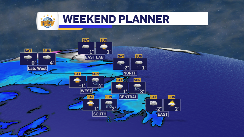
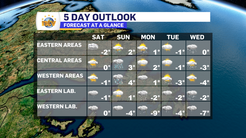
- Highs will be 2° to 4° on Sunday. Labrador will see highs near 0° Saturday and a tad cooler on Sunday, particularly in the west.
- Monday and Tuesday generally look quiet, with no major weather.
- A potent low will arrive in the region on Wednesday. This can bring significant snow and rain to NL for the second half of the week. Forecasts are still very uncertain at this point.
Sunday’s Forecast
Newfoundland: Mostly cloudy with rain and snow showers. Highs of 2 to 4.
Labrador: Mostly cloudy with scattered flurries. Highs of 1 in the east to -4 in the west and north.
Monday’s Forecast
Newfoundland: A few morning showers or flurries for the Avalon, otherwise partly to mostly cloudy across the board. There will be some flurries on the West Coast as well. Highs near 1.
Labrador: Periods of light snow. Highs of -2 in the east and -9 in the west and north.
Tuesday’s Forecast
Newfoundland: Mostly cloudy with flurries on the West Coast. Highs of -1 to -3.
Labrador: Periods of light snow and flurries. Highs of -2 east and -4 west and north.
Wednesday’s Forecast
Newfoundland: There is a high chance of snow for eastern regions, with a slimmer chance in central and west. Highs near 0 east and south to -4 west, central and north. The chance of snow increases for the rest of the Island later Wednesday and Thursday at this time
Labrador: Chance of snow. Highs of -2 east to -8 west and north.
There is currently a tremendous amount of uncertainty in the forecast for the middle and end of next week. At this point, it is still impossible to determine snowfall amounts and where the highest mounts will fall. I will update you throughout the weekend and next week as the system’s arrival gets closer. In the meantime, be cautious of any numbers you hear if that hasn’t come from a meteorologist.